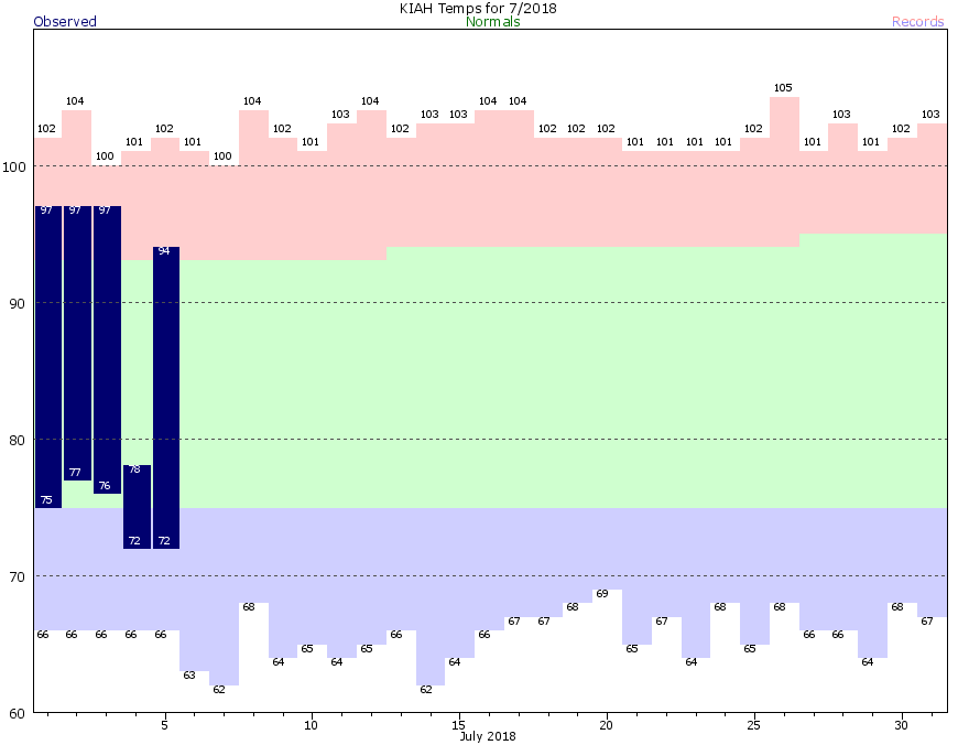
Anyone who has lived in Houston knows there are basically two choices for weather during the months of July, August, and the beginning of September: Hot, sunny, and humid; or Warm, wet, and still humid. Houston has experienced both of these extremes already in July, with three days of highs in the upper 90s, followed by a day of 70s and heavy rain on the July 4th holiday. Over the next several days we’ll lean more toward the warmer and wetter variety, with an eye toward more widespread, heavier rainfall returning Sunday.
Friday
Storms have remained offshore this morning, and some slightly drier air has worked its way into the Houston region. However, as temperatures warm into the mid- to upper-80s later this morning, and the sea breeze gets going, I expect we’ll see some decent rain showers this afternoon, with a few heavy cells setting up (like we saw on Thursday, with a narrow, but heavy band of showers near Highway 288 and the South Sam Houston Tollway). I don’t expect significant problems. Look for highs around 90 degrees, or a bit warmer depending on how much sunshine your area sees this afternoon.
Saturday
I expect Saturday will be a lot like Friday, although with a few more clouds, and slightly reduced rainfall chances. The potential for heavier rainfall remains low, and any intense storms should be fairly scattered in nature. Highs in the low 90s.

Sunday
We have slightly more concerns about Sunday, when deepening moisture and slow-moving storms could lead to some flash flooding problems. We don’t expect widespread, prolonged issues, but some of these storms could quickly produce a few inches of rainfall, and cause some streets to become temporarily impassable. (We’ll update this weekend, if needed). The region’s bayous remain in pretty good shape, and the heavier showers should dissipate with the loss of daytime heating. Daytime temperatures, of course, remain dependent upon the extent of rainfall in your area. In general expect highs in the upper 80s.
Monday
Monday will also carry a risk of heavier showers, but we don’t think the chances are as high on Sunday. Highs around 90.
Tuesday and beyond
Higher pressure should move southward beginning at some point next week, probably around Tuesday, which will begin to limit shower activity. I don’t think storms are going to go completely away, but we’re going to see quite a bit more sunshine, and consequently high temperatures will work their way back into the mid- or possibly even upper-90s.
Tropics
In case you missed it (and I had, because I’ve been on vacation), the first Atlantic Hurricane has formed—Beryl, out in the open Atlantic Ocean.
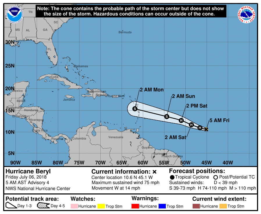
This is a small hurricane, and most likely it will probably weaken before it reaches the Caribbean Sea. It’s way too early to say what effects this might bring to the Caribbean or United States, but we certainly see nothing right now to be particularly concerned about.
I’m not a meteorologist, but if it were me writing, I would add May, June, all of September and the first half of October to the list of ‘warm’ months.
Hope you had a great vacation!
What he said!
Hello Eric and welcome back I hope your vacationings were wonderful! Thank you for the news about the rains coming Sunday! My dear Fulgencio is finally calm and eating after the scares of floods Wednesday. He even told me last night how much he enjoys learning more about the weathers from me telling him about your writings. We will start preparing in case the waters rise again! Blessings and thanks!
Welcome back Eric, you missed an eventful Fourth. Oh and happy Aphelion day.
Hi, Eric.
My wife is driving back from Mobile Alabama early Sunday morning. If the heavier storms do move through Houston on Sunday, at what time do you think that will be and from where will they be coming from? Thanks!
Off topic, what is happening with the volcano in Hawaii?
The Eyewitless News Team must have found better images of death and destruction elsewhere in the world.
https://www.express.co.uk/news/world/984981/hawaii-volcano-update-warnings-earthquake-ash-plumes
Warnings issued for next TWO MONTHS!!!