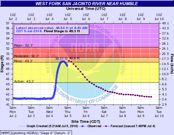
After yesterday’s wild weather, things will scale back a bit today, and we should end up calmer. All bayous and rivers are within their banks and generally lowering, including the San Jacinto River at Humble, which briefly popped into minor flood stage last night.
Calmer weather doesn’t mean totally dry, however. Over the next several days we’ll be dealing with a few disturbances to bring us more rain chances, though at this point none look quite as significant as what we just experienced.
Today
We’ll see a return of some sunshine and heat today, as we start the day partly to mostly sunny. A few showers will be possible south and west of Galveston this morning, down through southern Brazoria and Matagorda Counties. As we heat up, I do expect at least a few more showers and storms to develop elsewhere in the region, but these will be more of the hit and miss variety, with many neighborhoods staying dry today. Expect high temperatures in the lower 90s.
Any storms that do occur today will be capable of briefly heavy rainfall and some gusty winds, as well as lightning. So just be aware of that.

Friday through next week
With atmospheric high pressure to our north, our weather will continue to come from an easterly direction over the next several days. There are multiple small disturbances that will pivot around the underside of this ridge, bringing us a boost to our rain chances on several days between Friday and Monday or even Tuesday of next week. Again, at this point, none look quite as substantial as yesterday’s. There are two primary disturbances I’m keying in on: One goes just to our south on Friday, so perhaps rain will be enhanced in the Coastal Bend. The other comes through here on Monday. In between those, we’ll still be open to scattered showers and storms each day.
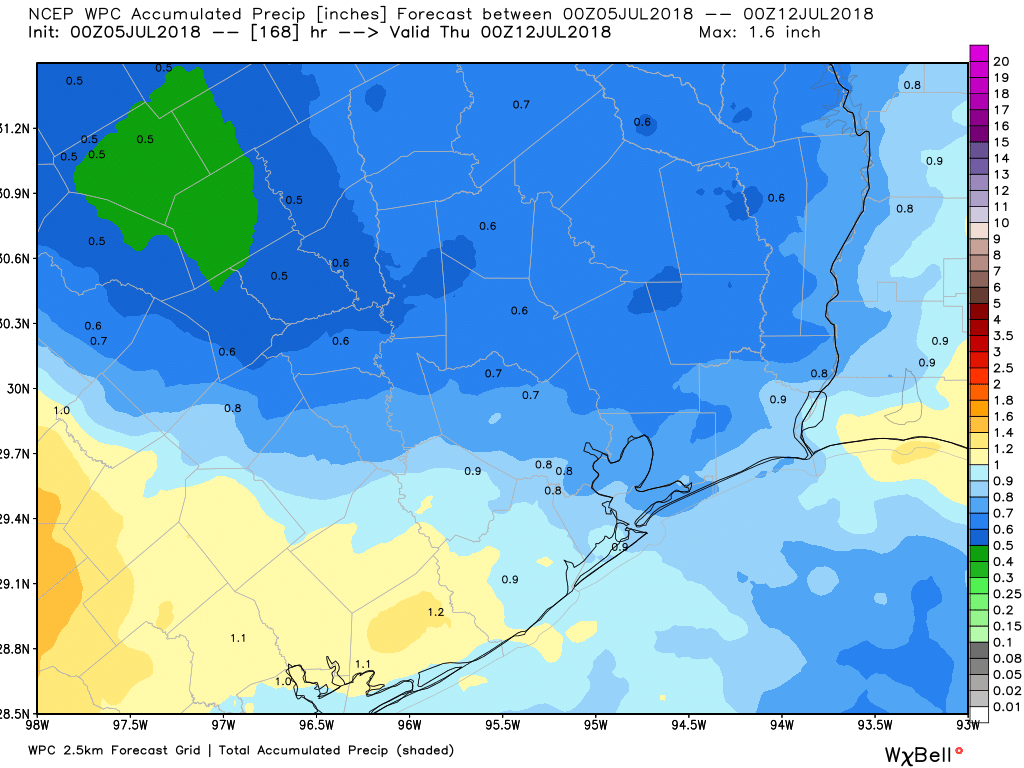
The rain totals map from the Weather Prediction Center is shown, and it suggests we’ll average about an inch of additional rainfall through next Wednesday. I am confident, however, that there will be a few smaller spots that see 2-4″ or even more spread out over the next five to six days. At this time, we don’t think it will come all at once like yesterday’s event. Flooding risk day to day is fairly low, but if we do get any slow moving storms, particularly with Friday’s or Monday’s disturbance, we will need to watch for some pockets of flooding.
Temperatures will be held down due to the rain chances and clouds, but it will still be hot and humid. Expect upper 80s to lower 90s each afternoon. We may see the pattern flip back hotter and drier after Tuesday of next week. More on that as we get closer.
Matt, should we be at all worried about disturbance 2 down there?
No sir. We’re all good. That may develop, but it’s unlikely to survive very long.
Thanks!
THANK YOU!!!
Matt,
Thank you for all the updates yesterday. Fantastic forecasting and a calm voice help keep panic levels in check. Hope you had some time to enjoy the day.
Out of the shower and into the sauna.
Funny how 2-4″ is just another day in Houston. For me, growing up in the northeast, the term downpour has an entirely different meaning. The rainfall rates in this city are just astonishing.
Everything is bigger in Texas! Unfortunately our rain totals, too.
I was curious about what constituted a 1 hour 100-year rainfall event and started poking around here: http://www.nws.noaa.gov/oh/hdsc/currentpf.htm
Very curious that except for a technical paper from 1964 which covers the whole country, Texas doesn’t seem to get much attention. Is it just too hard? Is the 1964 paper what engineers use today to design storm water systems?
Check this out in response.
http://www.jonescarter.com/blog/featured/atlas-14-what-is-it-and-how-could-it-affect-you-or-your-project
That link refers only to PF studies done by the NWS over the years. Its also important to make sure you are referring to the correct documents, as some durations have been superseded by newer documents, while others have not. For example, one hour duration from TP-40 is noted to have been superseded by the Hydro-35 document.
https://hdsc.nws.noaa.gov/hdsc/pfds/other/tx_pfds.html
While some parts of Texas still refer to TP-40/49/Hydro-35, most locations have switched over to the USGS Atlas that was completed in 1998 and then updated in 2004. However this Atlas only uses data up to ~1994 for most locations. Relevant links are below:
https://pubs.usgs.gov/sir/2004/5041/pdf/sir2004-5041.pdf
http://theodores-pro.ttu.edu/mytoolbox-server/TexasHydrology/TexasDDFAtlas/TexasDDFAtlas.html