It’s a bit of a messy forecast for the greater Houston region Wednesday and Wednesday night, so let’s break it down.
Wednesday
For the most part during daytime hours, the metro area of Houston, including immediately surrounding counties, will experience mostly cloudy skies, with a 30 to 40 percent chance of light to moderate rain showers. In Houston, rains look most likely around noon before a break this afternoon.
However, in the Brazos Valley including College Station, we have concerns later this afternoon, as an atmospheric disturbance migrates northward and combines with an approaching front. At this point, high resolution models point to the potential for some fairly heavy rainfall from mid-afternoon through the early evening. We’d expect some areas to see 1 to 3 inches of rain, with isolated higher totals.
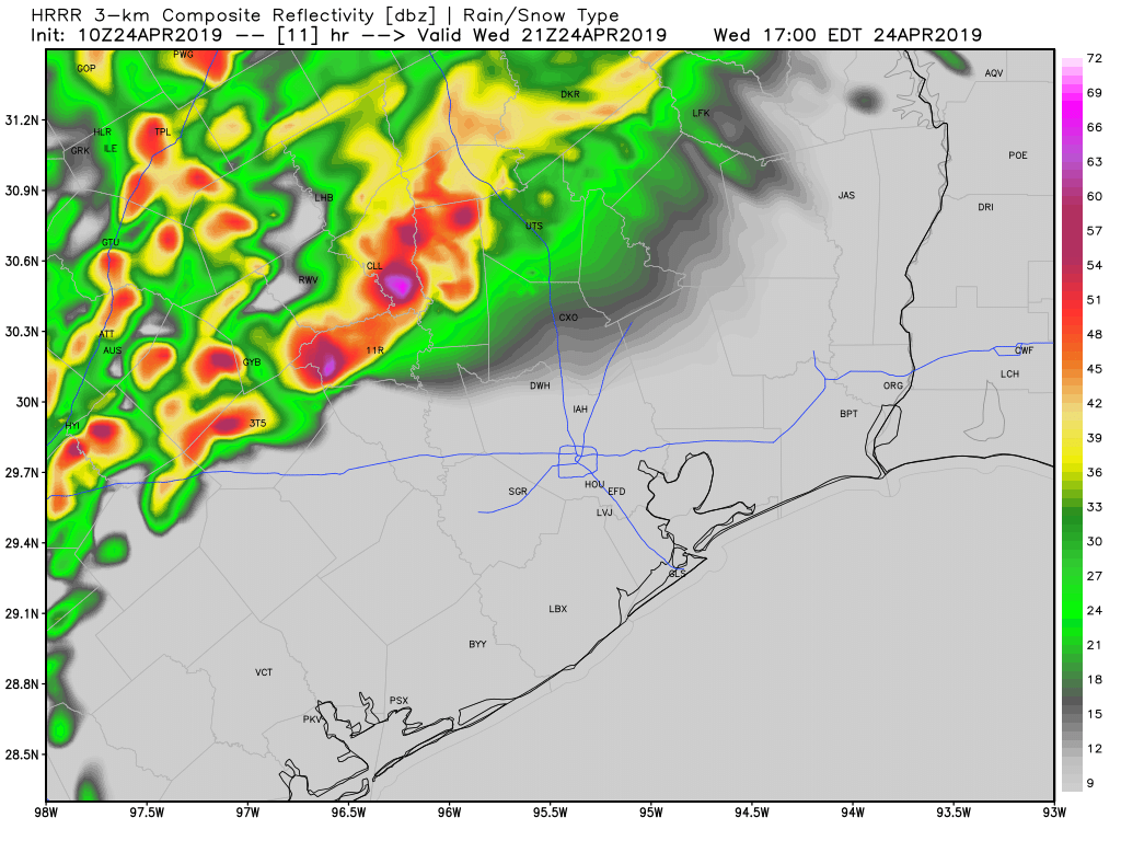
For Houston, itself, stronger storms are unlikely to move into the region before sunset (or later) as a line of showers and thunderstorms pushed through from west to east. I’d guess this line reaches the western part of the metro area between 7pm and midnight, and pushes through the city during the overnight hours. For now, the best chance of storms (mainly a hail and damaging wind threat) appears likely north of Interstate 10. Rain totals of 0.5 to 2.0 inches remain likely in Houston from this system, although I’m not sure whether we’ll see a solid line of storms, or whether it will be broken by the time it reaches Houston.

Thursday
The worst of the storms should be east of Houston by sunrise on Thursday, so barring a much worse than anticipated forecast, we don’t expect major impacts on rush hour. Skies should be clearing out by late morning or early afternoon, as a northwesterly flow brings drier air into the region. Look for highs Thursday around 80 degrees, with lows down around 60 during the overnight hours.
Friday
A splendid April day, with highs in the mid-80s, and lows down around 60 degrees. Low humidity, too!
Saturday and Sunday
The weekend forecast remains more or less on track. For Saturday, I think we’ll see highs generally in the mid-80s, with mostly sunny skies. If you’re participating in outdoor activities this weekend, the humidity will be somewhat lower than normal on Saturday, with a 5-10mph mostly southerly wind. Sunday will be a bit more humid, but still mostly sunny, with highs in the mid- to possibly upper-80s.
Next week
Some clouds will return by next Tuesday or so, and some slight rain chances will return by then or Wednesday, but we’re not seeing any real signals for the next round of spring storms. Sadly, there’s not strong signal yet for another cold front, and time is running out for us to hope for those as we near May.
Even with a normal everyday weather forecast, you guys are the best, as always!
So, the Cypress area appears to be in for a rocky ride….I cringe this time of year with the history of the Big and Little Cypress Creeks overflowing
Same!! Currently, they’re at normal stage and holding steady. But those up north that are at an “all time record today” are slightly unnerving. All that has to flow south… then add the rain coming in always makes me anxious.
This is a great link to check the stages, especially on a mobile device: https://txpub.usgs.gov/txwaterdashboard/index.html
The Cypress Creek watershed does not receive any water from “up north.” (The Brazos river is a different story.) Both Cypress Creek and Little Cypress Creek are at rock bottom, and one night of rain will not cause them to overflow their banks.
Absolutely true, I’m definitely no expert. I just cringe when we have these kinds of slow moving storms in April/May. The Brazos is expected to be at flood stage by Thursday. And then another rain storm comes through next week. But again, it took upwards of 12 inches of rain in 10 hours for the Memorial Day Floods. So maybe anxious isn’t the right word… cautious? I dunno. Just historically bad months for Houston and flooding is all I meant.
Is El Niño still a factor?
Any thoughts on air quality? During the last two or three sunny spells my iPhone’s weather app has consistently displayed a warning about “unhealthy air quality for sensitive groups.” Any sense of why this has become a recurring thing? Is it the aftermath of the chemical fires, or something else?
I’m in Galveston with a friend for the next 2 days. Any advice on the best timing for outdoor activities?
Any time tomorrow.
Skies will clear by or before noon Thursday. Any time thereafter will be great.
Thanks, Eric! It’s a beautiful morning here on the Island and the beach beckons …