Good afternoon! There has not been much change in weather modeling since this morning, which is a good thing for Houston, as that means we expect, with fairly high confidence that Tropical Storm Ida will stay well east of the Houston area, causing only some fringe impacts along the coast. Good news for Houston means bad news for someone else unfortunately, and Louisiana looks to see the core of impacts from Ida. The Gulf has been exceptionally unforgiving in recent years.
Right off the bat I just want to show you how far we have come in terms of track forecast confidence in the last 24 hours. Here is an animation showing yesterday’s ensemble “spread” from the GFS ensemble. Just to quickly recap: The ensemble consists of over 30 individual model runs, each one tweaked just a little at initialization (hour 0) and then run like any other model out over two weeks. The advantage of using an ensemble is that you get a wider range of possible outcomes, which can guide your forecasting, and it can also perhaps highlight areas of higher confidence. In this case, over a 24 hour period, the ensemble went from a wide, unruly range of outcomes to a fairly tightly packed group of outcomes.
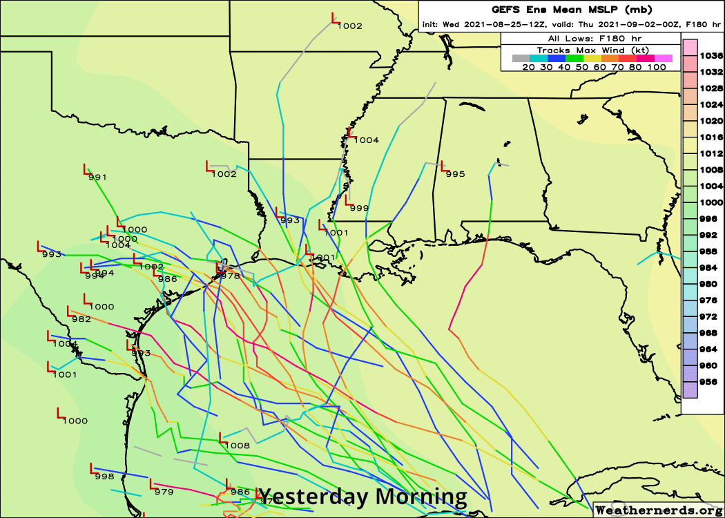
That helps boost our confidence. As you can see there, is still a bit of a range of possible outcomes, but instead of ranging from Mexico to Florida, they now primarily range from the Texas/Louisiana border to the Mississippi/Alabama border. And virtually all of these outcomes spare Houston any impacts.
Hurricane models are also in good agreement on this, so we’ve seen our confidence in a miss for Houston grow exponentially in the last 12 to 18 hours or so.
Here is the official National Hurricane Center forecast track for (now) Tropical Storm Ida.
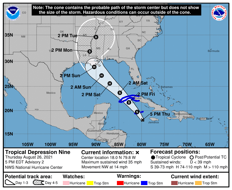
They are explicitly bringing it close to major hurricane status (110 mph is the maximum forecast at this time) as it makes landfall on the Louisiana coast Sunday. There is still some uncertainty around timing and exact intensity, but the takeaway message from the NHC discussion and forecast is that a strengthening hurricane is likely to make landfall in central or eastern Louisiana on Sunday night.
I know some folks are concerned about the Lake Charles area after last year. While they are not out of the woods yet, most model data and this forecast implies that impacts to Lake Charles would be fringe and mostly limited to just some outer bands with a few gusty thunderstorms. The Beaumont and Port Arthur areas should expect similar conditions.
Locally, we will want to keep an eye on tides, rip currents, and rough surf this weekend in the Gulf. If you’re planning a beach weekend, keep the rip current risk in mind, as swells from the storm approach Sunday into Monday. I will have some more on that in the morning.
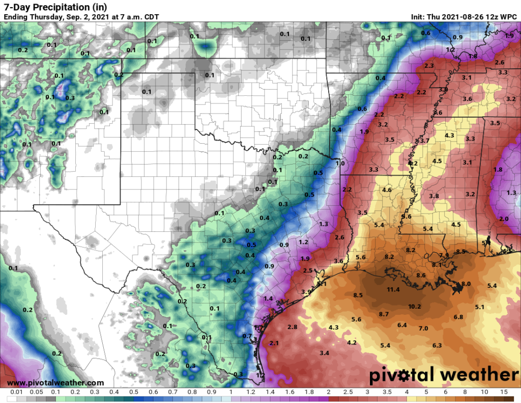
As far as rainfall, we should not see any direct rainfall from the storm here in Houston. The heaviest rain appears as though it will fall in central and eastern Louisiana and Mississippi.
Some of the storms we get the next few days in Houston, unrelated to Ida, could be a bit heavy, including some tonight. Storms will be moving east to west across the area, which isn’t terribly common, but again, this is not related to the tropical system. Eric’s morning post still looks good for tonight and tomorrow if you need some more details.
Beyond that, we can exhale in Houston for now it seems. There will be other tropical systems to watch over the next 2 to 3 weeks, but none of them looks like a specific threat to our area at this time. Surely that could change, but that is all we can say right now. In the meantime, our thoughts are with our neighbors to the east who will likely be forced to endure yet another considerable tropical system.
Thank you for your diligence and accuracy!
Don’t listen to him Katy, it’s still not safe for you!
“ Good news for Houston means bad news for someone else unfortunately,”
I wonder if there’s a German word for that- relief with a lot of sympathy and a shot of guilt.
There is schadenfreude, but that’s not really the right term in this case.
Thank you both!
Once again, SCW shows that you can inform without the hype. I didn’t have to endure wild gesturing, flashing graphics, and lots of “Breaking News” splayed all over the screen.
So, I’m thankful for Eric and Matt once again – and ready for the November (?) fundraiser.
Agree 100%, Thank you both for the sanity of your reporting and delivery!
Thanks guys. But, anyone with a brain needs to realize we aren’t out of the woods of hurricane season yet.
So, we’ll be keeping watch with SCW, pray for our neck of the woods AND our neighbors to the east and south of us for safety from any storms to come. And, most of all we ALL need to be fully prepared and ready to share with those unable to afford preparations.
So does that mean Katy is safe for now? Just want to make sure we don’t need to evacuate.
Katy is further from the coast than Houston, if Houston is safe In pretty sure you’re fine
You must be new around here.
I believe she should evacuate, but not because of the weather…
We used a similar “Monte Carlo” approach when trying to fit a newly discovered asteroid into its partially known orbit. Keep tweaking the numbers until the computed orbit resembles the actual orbit. Throw the dice, see what ya get.
Most folks, based on comments, don’t realize just how good TS modeling has become. I am still amazed at how accurate the models are this far from landfall. Especially with no center to work with. Now, if we could just something about the intensity modeling. Still some work to go there!
In 1961, the category 1 eye of Hurricane Carla passed about 85 miles southwest of Katy.
The only eye I have been in was Alicia, 1983 IIRC. Was pretty cool. I remember my brother and I out on bikes holding up cardboard as sails. I also remember we were without power for about a week!
While this storm could still track further west at landfall this forecast is a great relief.Thank you.
I’ll take a piece of this storm. Here in 77095 we are still under an inch of rain for August.
Thank you Matt and Eric for your straightforward reporting. We will be praying for our neighbors in Louisiana and all who are threatened by this storm.
In 61 it nearly destroyed Galveston..
I beg to differ…I live in Katy and my home along with 721 other homes in my subdivision were flooded. It was devastating and a total nightmare no matter what part of the Houston area you live in. You have no clue what you are talking about and probably should keep your opinions regarding Katy to yourself.
Yeah Emmy is extremely ignorant. You’ll have to forgive her she doesn’t get outside much .
The 1900 Hurricane traveled south of Houston and as a tropical storm wiped out all the structures except two houses in Katy, Texas.
Not even Christmas yet and we have a Grinch. People are having fun, lighten up, sheese.
Thank you for your thorough and informative report! We appreciate everything y’all do for us!
Is there reason we are not concerned that the NAM model is still showing Texas as where the hurricane will hit? I was under the impression that the NAM model was proving to be the most accurate model this hurricane season thus far so I was just curious? Thanks so much for keeping us informed!
In 1900 there was probably just those 2 houses and a sign saying Houston 17 miles. So it sign got damaged.
Any possibility of actually getting some nicer weather from this hurricane going east of us and the counter clockwise spin bringing dryer cooler air in?