Good morning. This post will address our increasing rain chances toward the end of this week, and then discuss the tropical storm likely to form in the Gulf of Mexico this weekend. The short summary is: The system will bring a lot of moisture with it, and while it may directly impact Texas, it may also make landfall east of the state. Please bear with us, we should have better confidence in a day or two.
Wednesday
The high pressure system that has been responsible for several hot and sunny days will start to retreat slowly to the northeast, and this will allow for more clouds to form today. This will lead to a few scattered showers this afternoon and evening, with perhaps a 30 percent chance of rain at your location. High temperatures should still get into the mid- to upper-90s so this will be something of a transition day to a wetter pattern.
Thursday and Friday
These days will see a mix of sunshine and clouds as upper-level disturbances rotate around the southern edge of the high pressure system. About two-in-three areas will rain each day, and for the most part two-day accumulations should be on the order of 0.5 to 1.0 inch of rain. This should help to moderate temperatures some, and we should look for highs in the low 90s both days.
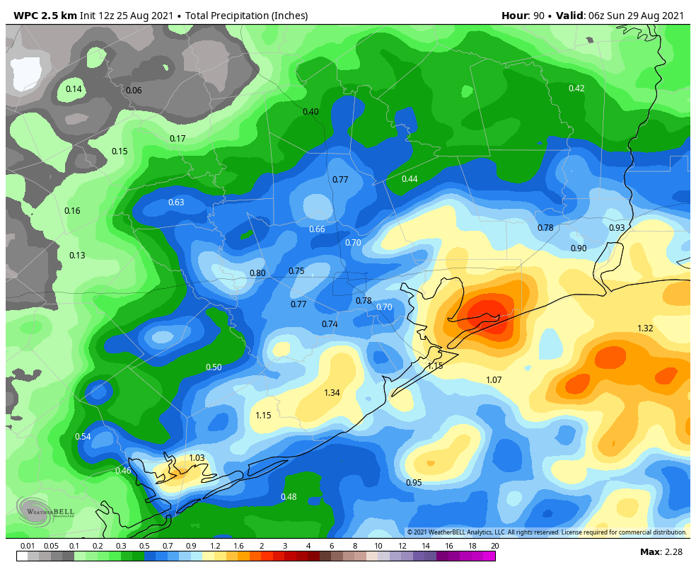
Saturday and Sunday
If you’ve got outdoor plans for the weekend you’re going to be rolling the dice. Saturday looks like it should have slightly less rain coverage than Sunday, but both days are probably above 50 percent in terms of your odds of seeing at least a passing shower. Sunday’s weather will be determined, in part, by the evolution of a tropical system now in the Caribbean Sea that should move into the Gulf of Mexico this weekend. And because there is so much uncertainty about that, it’s really hard to have much confidence in the weather forecast for Sunday and beyond.
Tropics
The National Hurricane Center now gives the Caribbean system, known as Invest 99L because it has been designated an “area of investigation,” an 80 percent chance of developing into at least a tropical depression or storm within five days. We think it’s highly likely that a tropical storm will form in the southern Gulf of Mexico by Sunday. So what happens after that?
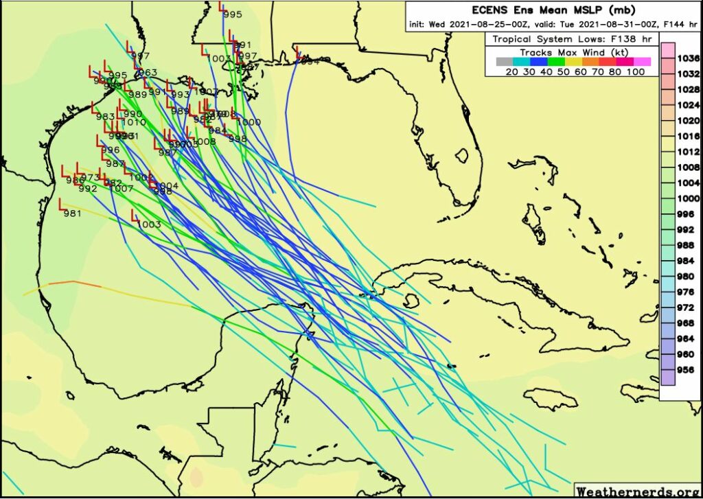
Yesterday the bulk of the model guidance suggested 99L would move toward the Mexico mainland or Texas, but we cautioned there was a high amount of uncertainty. Accordingly, overnight, the models have shifted dramatically. Now the models bring 99L toward Texas and Louisiana. Why the big shift? The upper-air pattern is complicated, and the models are struggling to identify where there will be a weakness in a ridge of high pressure over the southeastern United States, which would allow 99L to turn north. Another challenge is that, right now, the tropical system has no defined center of circulation. The models (shown below) should therefore be treated with skepticism.
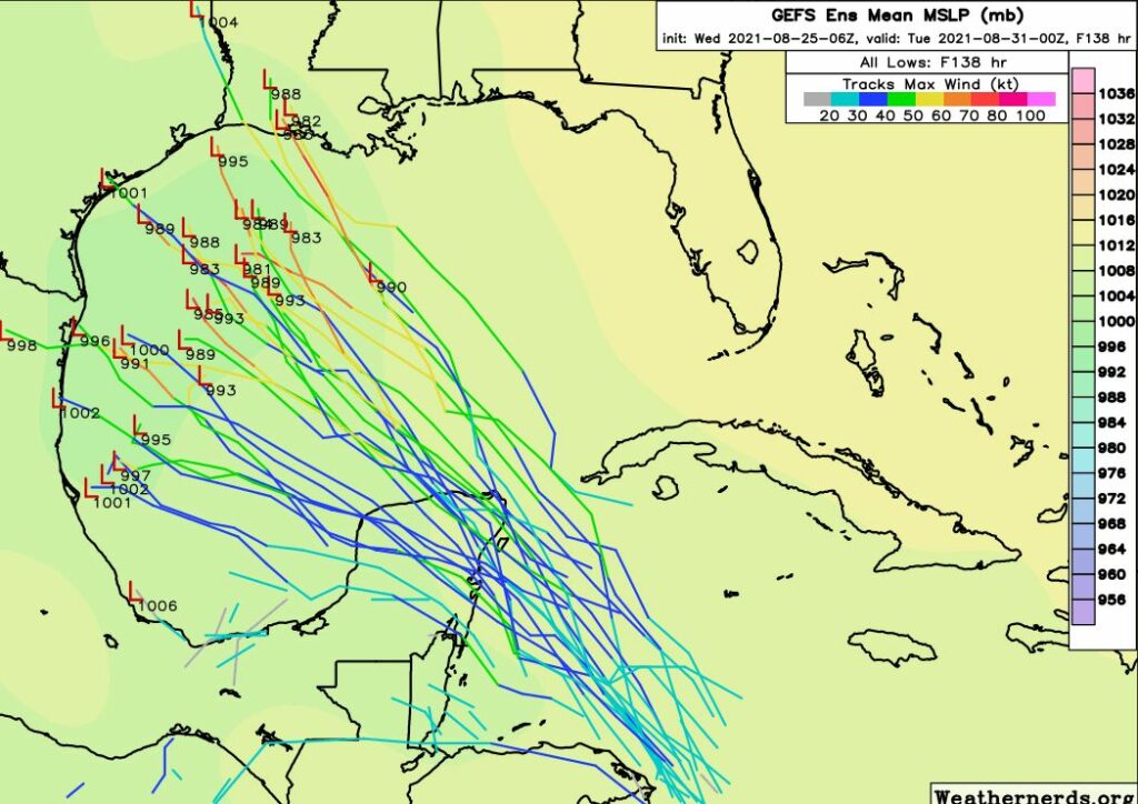
So what does this all mean? We probably will see additional shifts in projections of 99L’s track for the next couple of days, and you absolutely should not focus on any single model run. When our confidence increases, believe me, we’ll let you know.
As for impacts, the primary threat from this system is probably heavy rainfall, particularly along the storm’s track and to its east. However the Gulf of Mexico is plenty warm, and if the storm were to track toward Texas or Louisiana (instead of Mexico) it would have time to strengthen into a hurricane. These impacts are possible from later on Sunday through Tuesday.
If we get any clarity on the tropics forecast, we’ll update later today. If not we’ll see you on Thursday morning.
Thank you
Thank you for all your information
Thank you , with the anniversary of Harvey coming up this has my stomach in knots. BUT thankful that you guys are on top of this .
As always, it is great to have Eric, Matt, and Lee (webmaster) giving us the forecast with NO hype.
Those of you who have been caterwauling about wanting some rain should get out your rain barrels to collect all of this stuff so you can use it later. Added benefit: it won’t run into our streets and bayous to flood.
Ha! Agree! My dusty dry rain barrels are ready and waiting!I would love to keep some of the hoped for rain out of my ditch.
Thank you for better information than the tv guys. One of them had this possible storm hitting Rockport next Wednesday as a hurricane. So definitive with so little information.
80% chance of development = 130% of hitting Houston.
Not that last year has made me paranoid or anything…..
Why Is It Always Louisiana? (or Far East Texas)
Based on the past few years, of course it will not hit Houston if it can hit Louisiana. (and leave Houston to parch on the dry side of the storm)
Don’t have a good feeling about this one… The gulf is going to be quite favorable for intensification I’m hoping for some land interaction and some unexpected wind shear that can stop this thing from going absolutely out of control. Who knows where this will go, but I have a feeling somewhere on the gulf coast is going to get quite the surprise early next week.
Please stop.
Great forecast discussion. It’s not yet time to make a run on toilet paper.
Hoping for the best with this dice roll, as we’re scheduled to fly out of Hobby Tuesday morning for our daughter’s wedding in Pennsylvania. We’re tentatively booking a car rental should the need be required. Fingers crossed.
I hope for your sake and mine it GOES AWAY! My BFF and I are supposed to fly out Wednesday to Salem, Mass, for our first vacay together in 30 years. And we’ve already paid for the hotel!
Can you at least tell us this won’t be another Harvey?!
Can you explain, please, why Henri dumped so much rain and flooded NJ and other areas that were on the West side of the eye, as I understood it?
It rained at my house yesterday. These dry days have seen more normal August passing showers every day.
Should Katy evacuate?
This comment has gotten incredibly old.
nah not yet
You guys are awesome !
Houston Public Media just took the prize for most sensational weather forecasting I’ve heard in my 2.5 years in Houston. “Four years ago, Hurricane Harvey hit Houston and now there is another storm entering the gulf…most of the models show the storm hitting either Texas or Louisiana”
Unbelievable. Thanks to you guys for your transparency about uncertainty inherent to weather forecasting. The “check back in _ days” framework is very helpful!
Peter, thanks. The problem with so many of the media outlets is they spout absolutes, driving everyone into a panic. Our intrepid Space City weather forecasters deal in NUANCE, and give us a lot more good information. Does my storm-panicked heart good when the Harvey PTSD rears up.
Thank you for the facts about this scenario, including what we know and what we don’t know.