Good morning. Houston will have two more hot and sunny days before our weather transitions to a wetter—and perhaps a much wetter pattern—toward the end of this week and into next week. We’re going to need to watch the tropics closely, as we expect the Gulf of Mexico to see one and perhaps two storms between now and September 10.
Tuesday
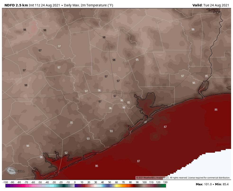
High pressure remains firmly in place for now, and this means Houston will see a hot and sunny day with high temperatures generally in the upper 90s. Skies will be mostly sunny, with light southerly winds. This will be a classic, late August day with a warm night.
Wednesday
Beginning Wednesday the aforementioned high pressure system should begin to slowly recede northward, and this may open the region to some slight rain chances. Areas south of Interstate 10 may see about a one-in-three chance of rain, with lesser chances inland. Skies should be mostly sunny, with highs in the mid- to upper 90s.
Thursday and Friday
With the high pulling away, we should start to see some atmospheric disturbances rotating around its southern periphery. This should bring increased cloud cover and approximately 50-50 rain chances for the end of the work week. This will help to moderate high temperatures, likely holding them in the low 90s.
Saturday, Sunday, and beyond
Saturday should see about 50 percent rain chances, and Sunday higher still as tropical moisture levels push into the area. Rain chances will be higher the closer one lives to the coast, with residents in Brazoria, Galveston, and Chambers counties probably having about a 70 percent chance of rain by Sunday. Skies this weekend will be partly sunny, with highs in the low 90s.
The wet pattern will likely continue into the first half of next week. How wet we get will depend on the ultimate track of a tropical system we anticipate will move in the Southern Gulf of Mexico at that time. If this tropical system moves into Texas, some part of the state could see 10 inches or more of rainfall during the Monday through Wednesday time frame of next week, but it is way too early to have any specificity of whether this will be Brownsville, Corpus Christi, the Houston area, or elsewhere.
Tropics
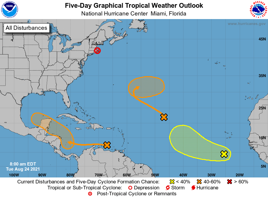
The National Hurricane Center has highlighted three areas of interest on its forecast map this morning, but for our purposes the only one that matters is the orange “X” in the Caribbean Sea. The National Hurricane Center gives this system a 60 percent chance of developing into a tropical depression or storm during the next five days, and nearly all of our reliable model guidance suggests it will become a tropical storm in the southern Gulf of Mexico on Sunday or Monday. Whether it becomes a hurricane depends upon several factors, including its interaction with the Yucatan peninsula. This is impossible to predict for now.
I am going to show you two forecast maps for the eventual track of this tropical system. They are ensembles from the GFS model and the European model, and the purpose of this is to demonstrate the considerable uncertainty in track. It is also clear that some kind of storm will very likely be coming to the Mexico mainland or Texas coast early next week, and that areas along and to the north of its track will be on the receiving end of significant tropical moisture. This is why we say that Texas is at risk for heavy rainfall early next week, but we cannot say precisely where.
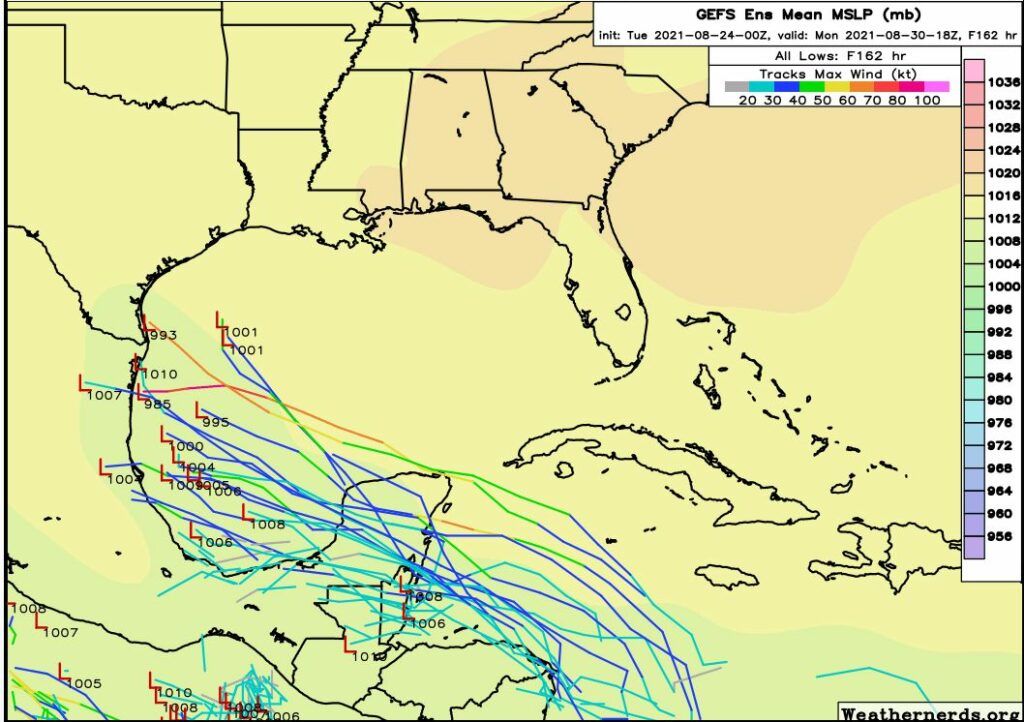
The GFS model, shown above, is more south than the European model. This would likely keep the heaviest rains south of the Houston region next week. Matt and I, for now, are leaning slightly in favor of this solution as the more realistic solution. But again, our overall confidence is quite low.
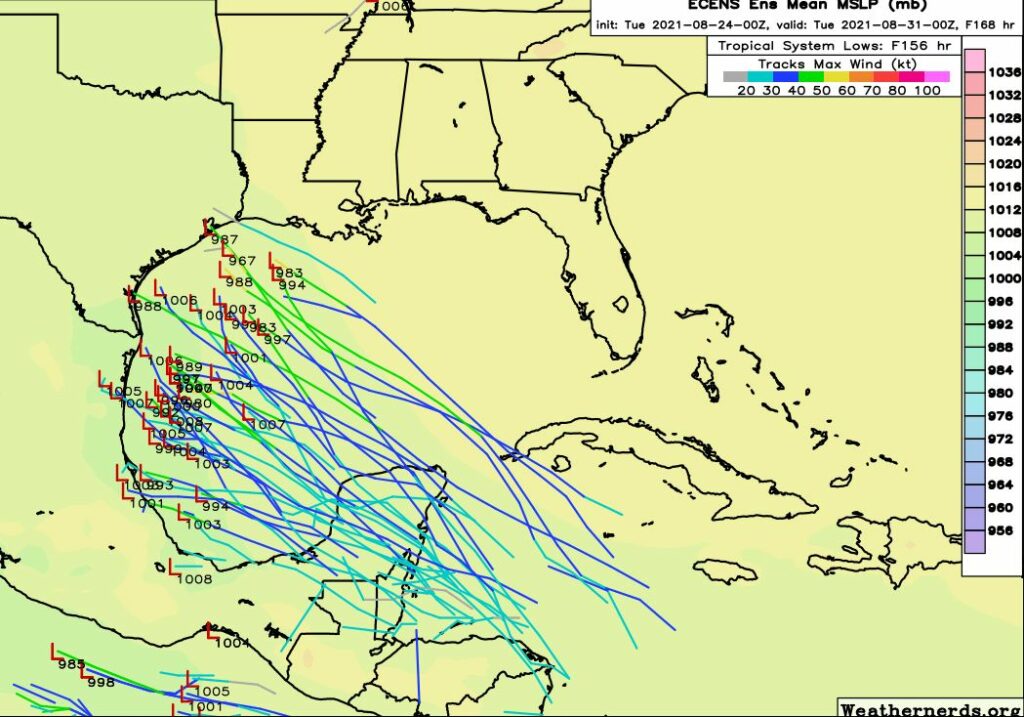
The European model brings a storm along a more northerly track about six days from now. This would bring heavier rains to Texas, including potentially the Houston area, next week.
The bottom line is that we need to watch the Gulf of Mexico closely. There are signs that yet another tropical storm may move from the Caribbean Sea into the Gulf of Mexico about a week after this one. We are approaching the peak of hurricane season and the tropics are acting accordingly. We’ll be on top of it for you.
Thank you so much for such a detailed report. I appreciate what you do and I’m grateful to benefit from it. Blessings to you always
I will be so glad when the rain returns. It’s really a chore for me to water the plants. Just planted several Rose of Sharons earlier this year and even though July was very wet, these plants were still showing signs of heat stress this month. Hopefully they will get hydrated for the rest of the year.
Also a great excuse to avoid mowing the lawn. I’d rather be watching Turner Classic Movies.
The money I pay to have someone else mow my lawn for me is the best money I spend. I’d cut off my internet access before I cut off my lawn service. 😀
“Rain chances will be higher the closer one lives to the close”
coast
Great tropical update. Nothing to really be concerned about until perhaps Sunday. Thank you.
Many thanks as always, and congratulations on Spanish version. So grateful for you two!
It rains all the time here. Yesterday, I was riding home from work under bright and sunny skies. In the center of the sky was a Thunder Master Cloud. It started to drop a light, misty spray of ray, by riding north or south, I was not under it but east to west remained under the Thunder Master. Amazing that it even rains from sunny skies here. Nothing can grow because the plants are rotting and the mealy bugs are devouring them.
Based off of the 12z model runs, I’d give it like a 65% chance Houston going to get major rain impacts (5+ inches) next Monday-Tuesday. Models are curving the hurricane more to the North now. Hopefully this won’t be a big windstorm.
We haven’t gotten a big tropical windstorm in Houston for the past 13 years.
Storms entering GOM below 22 latitude seldom make it to upper gulf coast based upon history. Mostly end up in Mexico or lower Texas. So will this one in my unguided opinion.
the GFS model moved the storm up to the texas coast in the latest 2 runs.
Upper Texas coast now based on last 3 runs. Let’s just call it in advance, Lake Charles will get this storm.