Tropical Storm Imelda formed Tuesday afternoon just before making landfall near Freeport, Texas. The storm will bring some moderate wind gusts into the upper Texas coast over the next day or two, but by far our bigger concern is heavy rainfall and inland flooding as the storm pulls copious moisture inland. To that end, we are escalating our alert to Stage Three on our flood scale. This means we are likely to see significant flash flooding. This post will explain why.

Timing
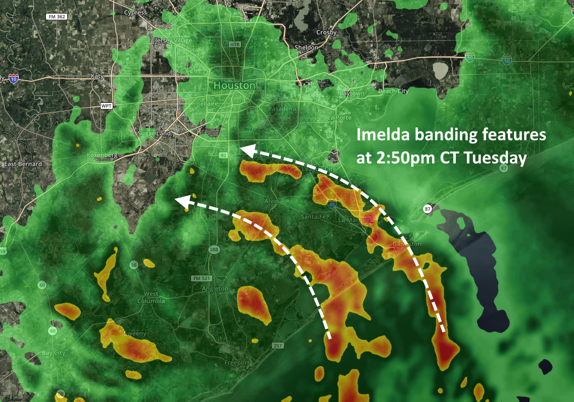
Probably the most notable shift in the modeling guidance has been an acceleration of when we expect heavier rainfall to begin. It now appears likely that heavier rains will move into Houston this evening, with banding features consistent with a tropical storm. We now also have increasing confidence that the worst of this will be over by Thursday afternoon or evening—so Houston appears to be locked into this mess for the next 48 hours or so. (It’s nice to have a fairly clear end point).
Tuesday night rains
A good portion of Harris County, and coastal counties, will likely see between 3 and 6 inches of rainfall this evening, during the overnight hours Tuesday, and through Wednesday morning. There may also be a narrower band that sees as much as 12 to 15 inches tonight, although it is not clear whether this will occur along the coast, offshore, or somewhere east of Interstate 45. Where this heavier rainfall occurs we probably will see significant street flooding due to extremely high rainfall rates, and potentially water getting into homes. During any flash flooding please remain in your location and do not venture out.
Wednesday afternoon through Thursday
As Imelda slowly lifts north, we expect the more intense band of rainfall to lift with it. So our biggest concerns for heavy rainfall later on Wednesday and Thursday will probably migrate to the Interstate 10 corridor and further inland. But frankly, we’ll have to reassess this after we get through Tuesday night.
As for overall event totals through Thursday, it seems a fair bet that most of the Houston metro area will pick up 5 to 10 inches of rainfall, with isolated totals of 20 inches or greater. Most likely these higher totals will occur somewhere east of Interstate 45, but whether that’s over Galveston Bay; East Harris County; or Liberty and Montgomery Counties, is difficult to say. More later. Hang in there, y’all.

Any word on any ISD closures in anticipation?
KHOU has some school closures posted.
http://www.khou.com/article/weather/tropical-storm-imelda-school-closures-in-houston-and-southeast-texas/285-b8f3e8ec-d031-4fb3-a6bf-9e760255dc75
Galveston ISD is closed tomorrow
If you lived in Kingwood would be comfortable driving in for the Astros game and getting back home safely after since we are so far north?
Thoughts on flights coming into IAH Wednesday afternoon?
Your seat cushion can be used as a flotation device in the event of a water landing!
I have same question as CD — I live in Spring and have tickets to the Astros game. Trying to decide what to d.
I am trying to determine if I should cancel an event that is supposed to take place in Midtown from 7-10pm…when do you anticipate the heavy bands reaching the inner loop area tonight?
Same issue as many above. Live in Sugar Land, but have Astros tickets.
I’ve got a big truck so I’ll take all y’all’s Astros tickets lol
I don’t think Eric wants to be put in the position of answering that question. I wouldn’t.
Didn’t ask him a question. And wouldn’t expect him to tell me what to do. Just venting, really. Bummed the weather messes up plans! Watching and staying informed so we can make our own calls on where and when we decide to get out in the storm.
I have a friend in surgery downtown. Should I attempt to go?
Are you a surgeon?
Thank you for your clear, concise and factual weather forecasts – without hype. So grateful to have you in Houston.
Dumping rain pretty hard right now in League City.
Thanks Eric!
Thanks for your much appreciated update.
Just wondering if you ever feel like a parent to your entire audience… the questions about what to do or not do make me laugh! Maybe a distinction should be drawn between a great meteorologist and Almighty God!
Lol some of the questions here… You guys just need a disclaimer or something that says “We apologize that we can’t tell every one of you how to plan your route or the minutiae of your evening or whether you should go to the astros. Please continue to check back here and keep an eye on x, x, and x resources. Turn around don’t drown.”
RS – I like the disclaimer idea!
Go watch and enjoy the game! Can always sleep in your car in a parking garage!
For folks who live closer to the coast: What sort of impacts are we seeing due to the crazy high tide today?! At what point today/tomorrow is the tide forecast to lower to a more reasonable level so that drainage can occur more swiftly? I live not far from Horsepen Bayou and the water levels are much higher than they ought to be if we had just received… ahem… a normal 3-4″ rain today.
My apologies for not knowing where to find tide local tide information. Thank you. Godspeed.
Oh the rains have started and my dear Fulgencio and I are staying in for the duration. This storm is way too soon for me as his tears from simply hearing the name Humberto have only begun to stop. Blessings to all! Stay dry. Thank you for the weathers news!!
Seriously people. If you have to question whether or not to get out in this weather…🤔 is it worth the risk of getting caught on a flooded street-or underpass, which there are plenty of…. and ruining your car…. you need to rethink your priorities!!! There will be other games. Oh wait… television! What a novel idea!!! Jammies, food, popcorn and beer… all in the comfort and privacy of your home.
Galveston is quiet as a church mouse right now. Not even a drop of dew.
Yep. It’s after 11 PM and barely any rain out there east of Houston. I’m really concerned that the overnight/early-early morning rain will get us like Allison did. I was lucky, but so many weren’t. They woke up to inches of water in their houses without much of a warning. Eric’s doing a great job of making us aware of the possibilities even though he’s not predicting a 5. Still makes me nervous! Y’all stay safe.
Humble isd is closed today.