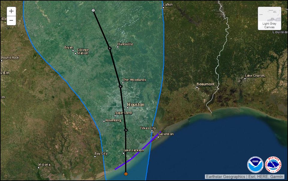
Today, the National Hurricane Center upgraded the low-pressure system in the Gulf of Mexico into a tropical depression. (Update: at 12:45pm CT the National Hurricane Center upgraded the system to Tropical Storm Imelda). As a result of this, a Tropical Storm Warning has been issued for the coast of Texas from Sargent to Port Bolivar. The storm’s forecast track, through Thursday morning, is shown below. The system should run rougly parallel to Interstate 45 once inland.
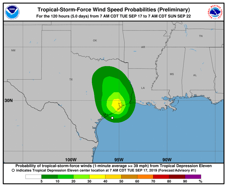
The formation of a depression increases the possibility—slightly—of this system bringing tropical storm-force winds into the Houston metro area later today and on Wednesday. However, the overall probabilities are low:
By far the greatest threat from this system remains heavy rainfall from now through Thursday. As noted this morning, the depression is bringing an exceptional amount of tropical moisture into the state of Texas. What we don’t know yet is where the heaviest rains will fall on Wednesday and Thursday. We think a few areas—maybe some isolated locations in Galveston or Houston or Beaumont or Lake Charles—could see peak amounts of 15 to 20 inches. But most of our region probably will receive considerably less than that, on the order of 5 to 10 inches, which hopefully will be mostly manageable.
Bottom line, there’s a lot of potential here for heavy rainfall, and we’re going to have to really track this closely as it brings flooding into Southeast Texas on Wednesday and Thursday. We’ll have a comprehensive update around 4pm this afternoon outlining what we know, and what we don’t.

It’s definitely coming this way. It sounds weird, but I get migraines before big weather events. I woke up this morning with the worst headache I’ve had in a while!
So….yet another Harvey. Fecking yay. I lost EVERYTHING in Harvey…….
Relax, this is nowhere near Harvey!
I don’t think it’s going to dump the same amount in a period of time and by Friday it will have gone, I hope!
ditto — and nothing touches it
My knees and ankles pain level today would agree with your assessment.
I get massive migraines before big weather changes as well.
Melissa, I also get migraines before a system moves in. Went to bed with one of worst last night and still have one now.
What are your thoughts on the weekend and our rain chances once this thing pushes through?
I’m supposed to fly into IAH at 8pm on Thursday. Should I go ahead and try to change plans?
Is there any risk of a storm surge or high tides in Galveston Bay? If so, how much and when?
Thanks for the great information.
…..And now it’s been upgraded to Tropical Storm Imelda:
..DEPRESSION BECOMES TROPICAL STORM IMELDA…
Surface observations indicate that the depression has strengthened
as it nears the coast and has become Tropical Storm Imelda, with
maximum sustained winds near 40 mph (65 km/h). A National Ocean
Service observing site at Freeport, Texas, recently reported a
sustained wind of 40 mph (65 km/h) and a wind gust of 47 mph (76
km/h).
No to the wind! I was dealing until that 🙁 I guess 40mph is doable if it must be but no more than that! Holy moly…I’ll be awake all night :/
Over night until noon 4.5 in our house near El Dorado and Space Center Blvd. intersection
Yes. I live near there and we got a lot of rain.
Go away, Imelda!
Over 3 inches on the west side of La Porte.
If I am traveling from the Astros game in Houston to Richmond this evening, will it be dangerous (flooding, etc.)? I am curious if I should not go to the game.
some models are projecting 10 inches possible around southwest houston overnight. It could be a difficult return home to Richmond, just depends on how quickly the main rain bands arrive in that area.
What are the chances that she parks over west-ish Houston, be it north or south of 10?
I sure hope you’re right that rainfall will be limited to 5-10 inches over most of Houston through Thursday. That would be pretty manageable, I think.
Our part of Texas does seem to end dry periods dramatically.
Just looked at NHC and I believe we have T.S. Imelda which made landfall near Freeport. This has to be some kind of record for shortest lived T.S.
I’m in Lake Jackson, how bad do you think it’ll be here ?
Thank you Space City Weather!
Eric, do you guys have an update now that it’s a tropical storm. 🙈🙈🙈😳😳😳
I have been waiting for this storm all season. I swear I felt it coming at 4am yesterday then it was named… Imelda!