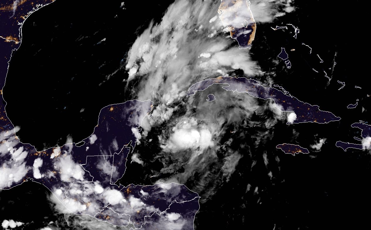
Good evening. Much as two tropical systems are swirling around in the Caribbean Sea this evening, forecasters are wallowing around in ignorance as we try to parse what will happen in the days to come as Tropical Depression 14, which is likely to soon be named Marco by the National Hurricane Center, and Tropical Storm Laura will do. (Update: The system was named Marco at 10pm CT). What does seem increasingly clear is that Laura may ultimately pose the bigger threat to interests along the Gulf of Mexico. Let’s start with the nearer storm.
TD 14
This system seems to becoming better organized, and it would not surprise me to see Marco forming tonight or Saturday morning as it nears the Yucatan Peninsula. This system is now likely to only graze the Yucatan as it moves northwest—which would therefore not substantially disrupt its organization—and this may allow for it to intensify through about Sunday, possibly reaching hurricane status over the Central Gulf of Mexico.
A stronger storm would likely to continue to push north or northwest, but it now seems that wind shear and other factors will work to weaken the storm. This probably will allow the system to be driven westward, into the central Texas coast. (We are still not particularly confident in a track, so stay tuned). So far the models are not overly excited about the rainfall potential of this depression as it moves westward, but obviously that is something we’ll have to keep tabs on.
Tropical Storm Laura
We have lots of questions about Laura, but we can be pretty confident that this system will enter the Gulf of Mexico late Sunday or Monday morning, having come near, or across Cuba. As it crosses the central Gulf of Mexico, Laura may find more favorable conditions to intensify. Several models now show it fairly quickly becoming a hurricane by Monday night or Tuesday over the Gulf’s warm waters.
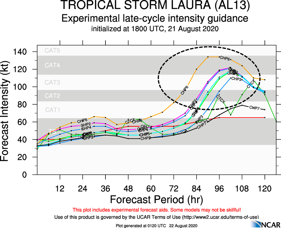
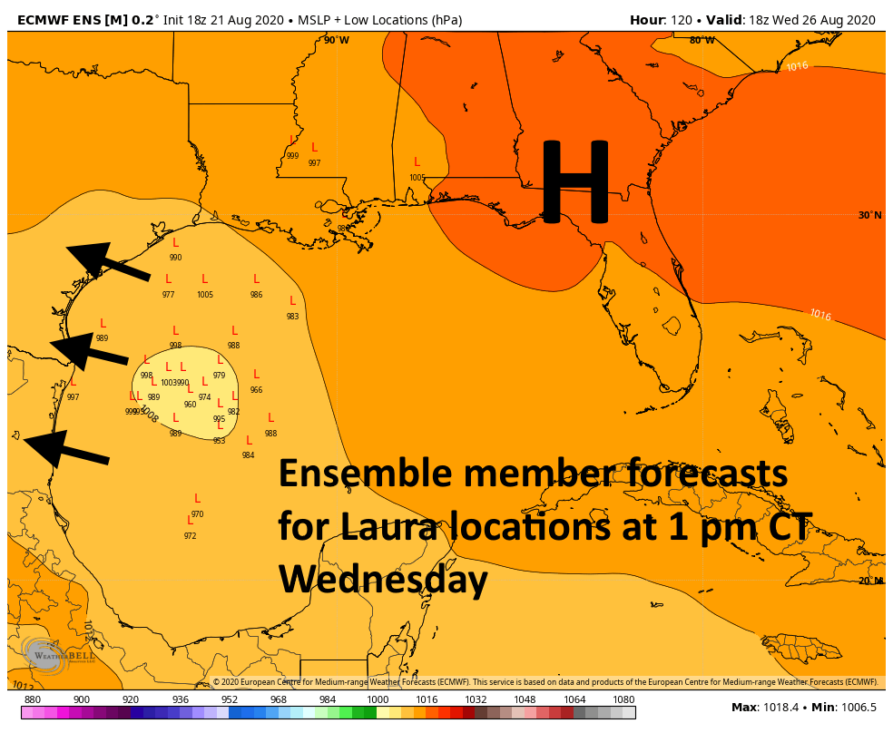
Then, there is the question of track. Laura’s path will depend upon the extent of a ridge of high pressure building over the Southeastern United States. Some guidance depicts this ridge weak enough by Tuesday or Wednesday to allow Laura to bend northward toward Louisiana. However, the latest (18z) run of the European model finds nearly all of its ensemble members driving Laura westward, toward Texas, with some kind of land-falling system on Thursday. We will have to see whether this trend holds in subsequent runs, and whether other models follow the European on a more western track. We may know more tomorrow.
So where does this leave us on a Friday night? Besides at home and in need of a glass of wine, that is? We’re still left with the need to watch two tropical systems. For now, it appears that TD 14/Marco may be somewhat benign as it moves toward Texas early next week, but that is far from guaranteed. Interests in Texas and Louisiana should also keep more than a wary eye on Laura, which appears to have better potential to develop into a hurricane, and possibly a powerful one, next week.
Our next update will come on Saturday morning before 9 am CT.

Why is it that the cone of uncertainty is always the same size on NHC’s forecasts? If a storm’s track really is especially uncertain, why can they not expand the cone’s width even more further into the forecast? What do they have to lose by doing that? If the 5-day out cone needs to spread from Nola to Port Aransas, then so be it. Apologies if this has been explained before.
Great question — I think this is probably the answer you seek: https://www.nhc.noaa.gov/aboutcone.shtml
“The cone represents the probable track of the center of a tropical cyclone, and is formed by enclosing the area swept out by a set of circles (not shown) along the forecast track (at 12, 24, 36 hours, etc). The size of each circle is set so that two-thirds of historical official forecast errors over a 5-year sample fall within the circle.”
As to why it is not adjusted to fit each storm, I suspect this is probably because it is difficult to quantitatively estimate uncertainty in real time.
My understanding is that the cone is derived from a consensus of the latest model runs. If most models are in agreement, you will have a very thin cone. Widely disparaging models will result in a wider cone as time goes by, reflecting the uncertainty. Maybe Matt or Eric can confirm this for us
Thank you, Matt and Eric. I stopped watching weather on TV in 2008 due to Eric, my “go-to”, honest, no bs weather source.
It can only be 2020… With all these factors at play, you guys may as well kick back & watch the Astros along with some ice cold Crawford Bock tomorrow as I’m thinking forecasts of both storms will be equivalent of Joe Niekro knuckleball (don’t know how I turned this comment into an Astros post!)
Does this mean that Laura and Marco may cross paths or will Marco hit Texas before Laura?
This seems unlikely at this point.
Thank you Eric and Matt, looking forward to your update tomorrowrow morning
Less than 24 hours and Laura went from a nothingburger to possibly a major cane hitting us. Are these at least small storms? I remember Ike was as big as the Gulf of Mexico. How far inland are hurricane force winds likely to reach?
Is the Wednesday 1 pm graphic actually Laura? The timing looks more like Marco
Can you comment on the “Fujiwara effect” please?
See the last post. They go into detail about that in regards to these two systems.
So Laura is now expected to possibly be a Cat 4 or 5 as it makes its way across the Gulf slamming into Texas? What are the odds that Marco suddenly becomes a Cat 3 at this point?
How much further west is Laura expected to drift? The latest from NOAA shows it to impact Louisiana, with the Beaumont/Sabine Pass area on the far western edge. The intensifying of Laura surprises me. I’m not seeing anything like that in any forecast.
Thanks for going overtime for us!
Wouldn’t Marco cool the Gulf some so that if Laura turn west to Texas it wouldn’t intensify as much?