Good morning. We still are trying to parse details about tropical storms Marco and Laura, and we still don’t have solid information about what will happen. The bottom line is that, from Monday through Friday, the greater Houston region needs to be prepared for the potential of tropical weather—from heavy rainfall, to storm surge and strong winds. None of these are guaranteed, and there is no cause to evacuate now. But you do need to be prepared for rapidly changing forecasts.
Tropical Storm Marco
It appears that Marco has begun to intensify further overnight, and the storm has 50 mph sustained winds. If Marco continues to strengthen further this weekend, up to hurricane strength, it likely will take a more northerly track, toward southeastern Louisiana. However a weaker storm is more likely to move more westward, toward the central or upper Texas coast. Why? Because a stronger storm might have more impetus to barrel into building high pressure over the southeastern United States, whereas a weaker one would be more steerable to the west. Here’s a map showing the National Hurricane Center forecast track (in black) along with a couple of scenarios:
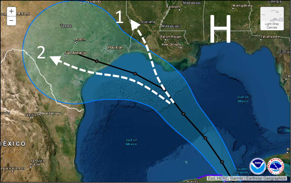
Scenario One, in which Marco never really makes a leftward turn while over the Gulf, would lead to limited impacts for the Houston metro area and the potential for heavy rainfall in southern Louisiana. Scenario Two will bring a decent amount of rainfall to the Houston region—2 to 6 inches, maybe?—along with elevated tides. At this point I would weight these two scenarios equally, in terms of probability.
Because there is so much uncertainty in the track and intensity, projecting other effects such as a storm surge is sort of fruitless. However, probably a worst case scenario is seas about six feet higher than normal along Galveston by late Monday. Peak winds, of tropical storm strength, would likely arrive here by late Monday. All of this is subject to change. All of this.
Tropical Storm Laura
Oh, we have many questions about Laura as well. At present the system is fairly disorganized, and contending with its “center” moving over Puerto Rico. What happens over the next 24 to 48 hours will probably have important implications how how menacing Laura ultimately becomes when it moves into the Gulf of Mexico. Here’s what I mean by that:
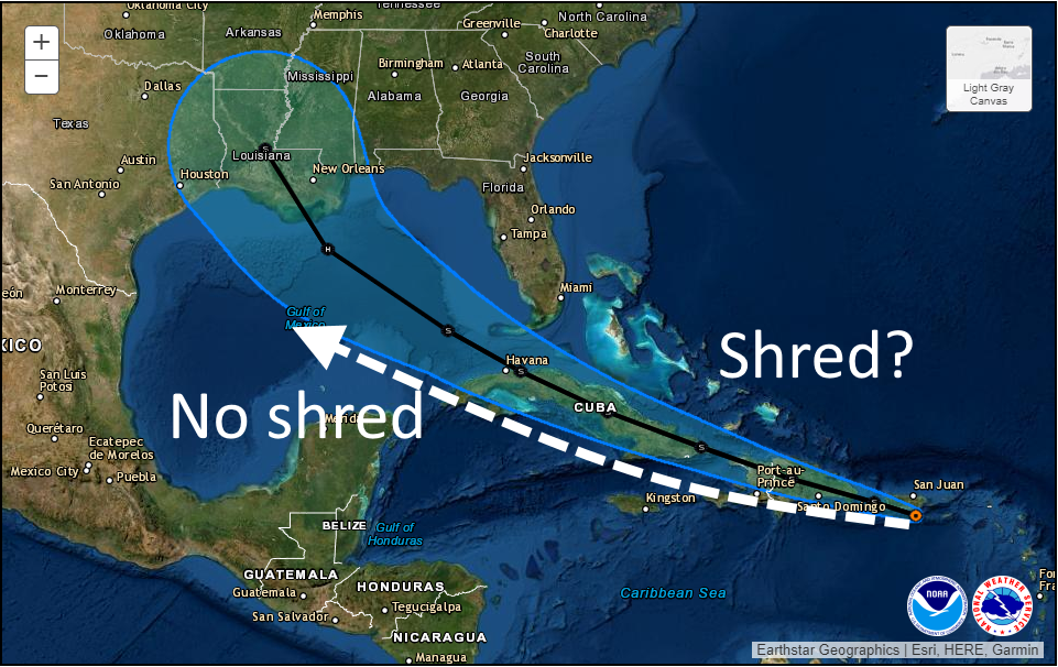
Along the current National Hurricane Center track (shown in black) Laura will traverse the mountainous terrain of Hispaniola, followed by the spine of Cuba. If the system is already a struggling tropical storm, it is difficult to see how a particularly organized system emerges into the Gulf of Mexico. Therefore the threat of Laura becoming a hurricane next week diminishes. However, if the storm can find a track just south of the islands, then it has a chance to escape the shredder and move into the Gulf later on Monday poised to intensify.
In terms of track, anything is still possible. Under the “no-shred” track above, Texas would probably be threatened by a hurricane next Wednesday or Thursday. Under the shred track, a weaker system probably comes toward Louisiana. But our confidence in a track remains very low.
We will next update the site by 3pm CT.

This is a hard one to read, Thanks guys appreciate your info. I don’t know rather to start getting myself ready or hold off until Sunday. Thanks again
It’s never too early to start getting ready!
Thank you for your no nonsense predictions.
Thanks for giving us the most up to date info without scary embellishments no one needs to hear.
Based on this post and the information coming out overnight, I’m starting to think that Houston is mostly safe from being affected by a large windy hurricane that can knock out the AC and gas stations for a week (like with Ike). If Marco gets strong, he goes into Louisiana and if Laura gets strong, she goes straight into the coastal bend. Yes, I know that’s not entirely certain.
Either way, at some point this week Houston is going to get a lot of rain, but it does feel like the hurricane “threat” just isn’t there.
As long as this “lot of rain” doesn’t just sit on top of us for 4-5 days, I think we can handle it.
I like the way you think
Thank you. I decided to get prepared today and the stores have plenty of water and supplies but D batteries are becoming scarce due to battery operated radios and fans. The biggest problem looks like possible flooding in some areas so far.
I will keep checking in with you!
I like your hopeful comments.
I have absolutely no idea what to expect. I’ve been around here long enough to understand that storms are unpredictable. But, this is unusually so. It is difficult to make a best bet decision.
I watered my plants this morning as usual. If and when the rain approaches I will fertilize said plants. Shade structures and anything that can fly around are put away – if no storms arrive still a great time for fall yard cleanup.
You mean summer, pt. II. Fall is a longggg way off.
Given that it’s 2020, be prepared to be hit by both………..
This must be a dream for the local TV media.
Frank Billingsley looked like he was going to wet himself last night he was so excited….😁
I don’t watch those guys anymore. 🙂 Was he also screaming, “The sky is falling, the sky is falling?” 🙂
Let me add my thanks for the latest no-hype forecast. I haven’t turned on the TV weather in months and don’t see a reason to now. No one needs that noise.
I’d be okay with cloudy days and the occasional thunderstorm but let’s send this rain to our rice fields in Louisiana, the Edwards aquifer in the Hill Country, or points west. Share our bounty if you will.
Just in case, even though we’re in The Woodlands, I filled up my gasoline cans yesterday. Already have plenty of non-perishable food, batteries and dry milk. Making blocks of ice in freezer as I write.
In the worst case scenario where drinking water treatment plants are impacted, if you have a tank style water heater in a house, that’s typically 30-40 gal of safe, treated water. If there’s a “boil order,” turn off the heater, and close the supply valve to it. Don’t use that to shower or take a bath. For sanitary purposes, clean at least one bath tub then fill it 24 hours before projected landfall. And you can treat that bath tub water with 10-20 drops of unscented chlorine bleach per gallon to make it safe to drink. Might not taste great, but no “bugs” in it.
Be prepared and stay safe everyone!
Many thanks, as always, for bringing clarity and sanity to a confusing situation. Your quick summation of the potential scenarios, and putting the facts into easy-to-understand terms, is why I quit following the local news guys years ago. Thanks again!
…absolutely outstanding update…even though we are days away from getting through this, you guys make the “journey” less stressful for me as you clearly state what you know and what you don’t know…soooooo refreshing…thank you!
Do you think Marco will be like Humberto? That was a tiny hurricane that hit the Houston area, but we didn’t see so much as a leaf rustle on this side of town.
I am curious why the increase in shear and strengthening of the Atlantic ridge that will affect Marco will not affect Laura.
It is also puzzling how nobody is discussing how SAL is keeping Laura from intensifying. Quite a lot of dry air in that area and moving towards us.
Hello old friend. We always seem to meet at this time of year every couple of years. Nice update. Thank you.
As someone currently out of town, I’d like to fly back to Houston in advance of the storms. Do you think I’ll be able to return Monday afternoon or is my best bet to try and return tomorrow(Sunday)?