Good morning! After its first 19 days, this month was on pace to become Houston’s warmest July ever on record, besting 1980 by nearly 1 full degree. However, with cooler weather ahead this week due to clouds and rainfall, we should back off those temperatures somewhat. Indeed, the story for the next week will be rainfall and tropical moisture, with two tropical waves headed this way.

Monday
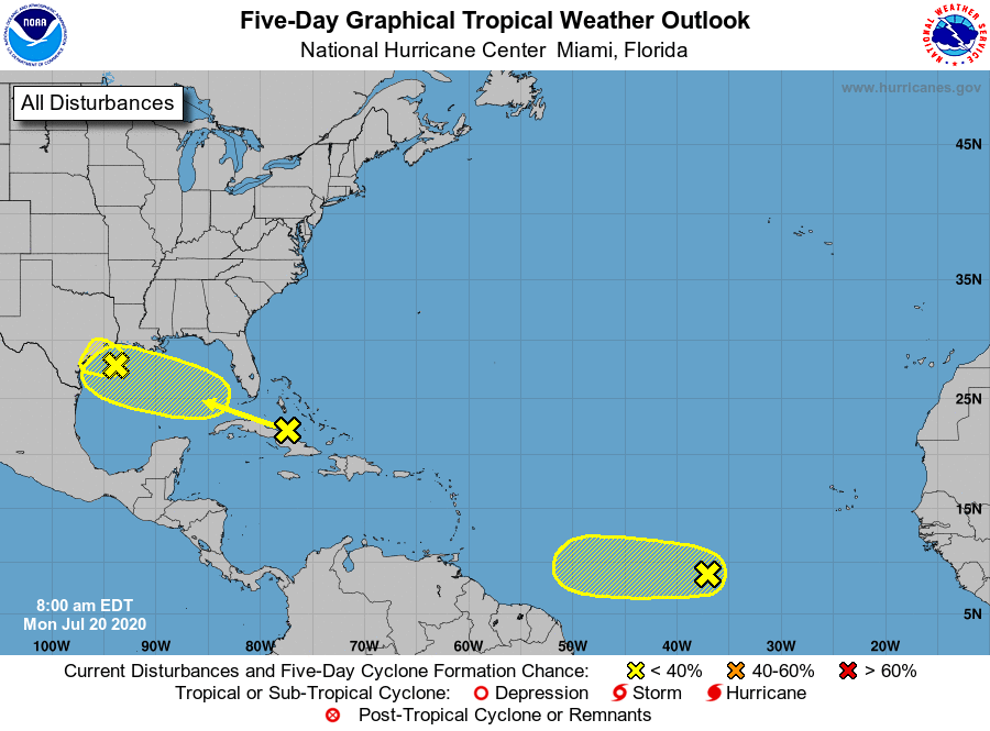
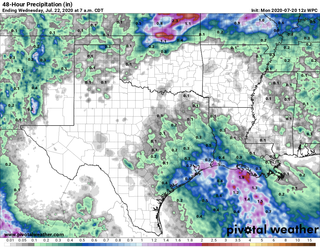
The first of two tropical waves lies just off the Texas coast, and will push inland today and Tuesday. (Note: The National Hurricane Center has given this system a 10 percent chance of forming into a tropical depression). As this moisture moves inland, we’re likely to see a greater than 50 percent chance of rain for coastal counties, and a less than 50 percent chance of rain for inland counties. Overall accumulations should be on the lower side Monday, with most areas likely seeing one-half inch of rain, or less. Clouds will help limit temperatures in the low 90s, with overnight lows in the upper 70s.

Tuesday
By Tuesday, as the bulk of the tropical wave moves onshore, much of the area should see a healthy chance of rain showers, well above 50 percent. Accumulations for most people should be about one-half inch of rain, but due to the tropical nature of this moisture, we probably will see some bullseyes that produce up a few inches of rainfall fairly quickly. With cloudy skies and showers, high temperatures should be limited to about 90 degrees.
Wednesday and Thursday
Some rain chances will linger for both of these days, but we expect showers to be of a more scattered nature. With drier air, we can expect to see some sunshine on both of these days, and this will allow high temperatures to climb into the low- to mid-90s.
Friday and Saturday
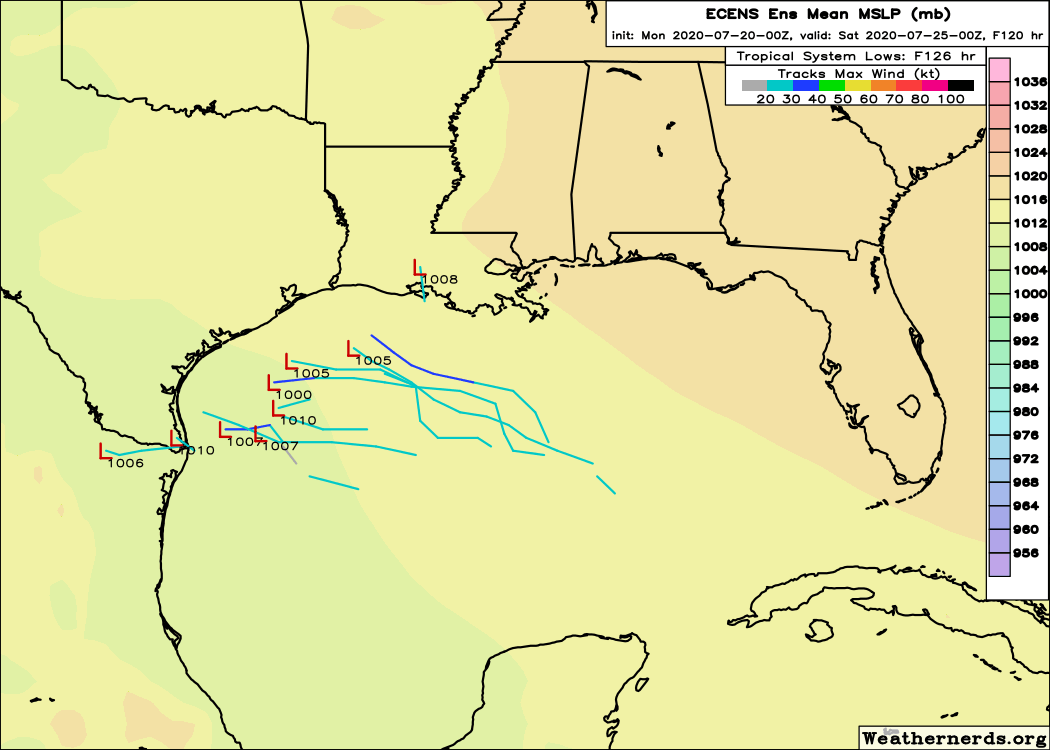
A second tropical wave will approach Texas on Thursday night, and this one has a slightly better chance of organizing into a tropical depression or storm as it moves across the Gulf of Mexico. The National Hurricane Center predicts there is about a 20 percent chance of this system become a tropical depression or storm by Saturday morning. There is some support for this in the ensemble models, and it would not surprise me to see this become a depression. However, for now there remains little (no) evidence for anything stronger than a weak tropical storm, so the primary threat from this system is likely rainfall.

For coastal Texas, this probably means an increase in rain chances to about 70 percent for both days. But so far accumulations look manageable—perhaps a few inches of rainfall along the coast as the system should move steadily to the west or northwest. Needless to say we’re monitoring this closely, but right now we see no cause for alarm. Highs both days will likely top out at about 90 degrees.
Sunday and beyond
After the second tropical wave, we anticipate rain chances settling down some, with a warming trend likely heading into the beginning of August.

Keep the clouds coming…. keeps the A/C bill down. I know I’ve complained about my office being 68 degrees in the morning but at least it was free. Now if I want to freeze to death in July, I need to pay for it!
” the primary threat from this system is likely rainfall.” Not the most comforting words for anyone who has lived here at least three years……
at least i’m not the only one missing the coldness of the office that i used to complain about – ha
and i second the mixed feelings about “primary thread of this system is likely rainfall”… but i guess it’s better than rainfall AND wind!?
Thanks as ALWAYS for an honest report on the tropics, e.t.c. The paper felt it neccessary to amp up the hype with “A “tropical wave” making its way through the Caribbean could batter southeast Texas, according to the National Weather Service” “could batter” yeesh, way to foment the fear…
Tropical wave “batter”? With what, a wet noodle. Sheesh.
Never fear, the Eyewitless News Team will have their mobile units deployed to catch the first rain drop hitting a Houston freeway. After all, they are keeping you and your family safe. From a half-inch rainfall.
Another note of thanks to the calm reporting of Eric and Matt. It is okay to stay informed but those TV hucksters can be emotionally draining as they try to one-up each other constantly. That’s why I don’t watch TV weather any longer. Who needs that aggravation?
Meanwhile, I’m with Blackhawks Fan on “keep the cloud cover”. Each summer day in the lower 90s is a good stalling effect until we get to fall and I’ll take it.
Aren’t storms forming out at the Atlantic near that other wave generally worse for us come July/August? Seems that we get more come across the lower Caribbean, cross the Yucatan and then hit us.
Obviously lots of variability, but it seems the further south it forms, the harder it swings into the Gulf.
Honestly, everything you post here sounds like good news. One or possibly two weak tropical systems producing rain in moderate but likely not extreme amounts, and without super high winds. Sounds like what we need.
Aaah, 1980. We baled hay on the 4th of July. Despite our experience with this process (make hay while the sun shines is not just a saying) I ended up in the emergency room with heat exhaustion. My husband had it too, undiagnosed, and I finally convinced the nurses to at least bring him some orange juice. When we got home we found his horse dehydrated and bumping into the walls. We were fortunate to have a wonderful vet who came out and gave him IV fluids (most mobile vets won’t). We were all fine the next day.
Clouds are good. Some rain is also good. The only downside is my son’s baseball games might be rained out–these are games left over from spring when the league shut down.