Good afternoon. Hurricane Laura has rolled on into Arkansas this afternoon and weakened to a tropical storm. However it has left a trail of destruction in its wake. This post will be very image heavy, with a number of pictures of damage that caught my eye through the day in Louisiana that I’d like to share. A quick forecast update will follow.
Let’s start with the Doppler Radar. The Lake Charles Doppler, sited at the airport south of the city (which reported over a 130 mph wind gust) saw its radome blown to pieces.
LCH radar is going to be down a minute…. #Laura – pic.twitter.com/7F1JAvm3y3
— Brett Adair (@AlaStormTracker) August 27, 2020
This looks a lot like the Doppler in Puerto Rico after Hurricane Maria in 2017.
The scenes in Lake Charles really do look like a giant tornado just ripped through the city. The one large skyscraper in downtown Lake Charles, Capital One Tower sustained severe damage. This building also took a severe hit during Hurricane Rita in 2005.
First light allows us to see the scope of the damage in Lake Charles this morning. Needless to say, its not good. pic.twitter.com/cJVI3y9Y3n
— Matt Reagan (@MattReaganWX) August 27, 2020
The KPLC-TV tower crumpled and fell onto or adjacent to parts of the TV station building. This one had apparently survived Audrey, Rita, and Ike, but finally succumbed to Laura.
KPLC Tower @hurricanetrack pic.twitter.com/wa6UM4sUd8
— GregNordstrom (@GregNordstrom) August 27, 2020
There had been some speculation that the I-10 bridge in Lake Charles (which, if you’ve ever driven, you just know, trust me) might sustain difficulties under a record storm surge. Well, it’s still standing, although it has a casino boat stuck underneath today.
The Isle of Capris Casino boat is WEDGED underneath the I-10 Bridge 🥴🥴 #HurricaneLaura pic.twitter.com/06Kfm0LmXs
— Drunk Uncle 🥴 (@iduffelshuffle) August 27, 2020
Lake Charles did not receive the expected record surge thanks to a landfall basically right at Calcasieu Pass (had it hit land even just five miles west, the story today would be much different), but they did receive a pretty serious surge in that area.
That surge was notable, however, it can be seen from space.
The effects of #Laura’s storm surge in SW Louisiana is visible on satellite. The top image is Tuesday and the bottom image is now. Note the temporary regression of the coastline. This water will gradually retreat into the Gulf, but this shows how big of an impact surge can have. pic.twitter.com/OVShOy2KcD
— Hank Dolce (@hankd_wx) August 27, 2020
You can see especially east of Calcasieu Lake (the 2nd larger inland lake from the left) how much land mass ended up underwater. There is a reason that part of coastal Louisiana is not heavily populated.
Back in the Lake Charles area, in addition to everything, a large fire broke out (not at oil refineries as the tweet says) at the KIK Custom Products Biolab in Westlake, just off to the west of the city. The fire prompted a shelter in place order for the area.
Large fire near oil refineries – Lake Charles @hurricanetrack pic.twitter.com/yk6QkpUjqf
— GregNordstrom (@GregNordstrom) August 27, 2020
The wind damage in Lake Charles is just incredible. Though they escaped the worst of the water, they paid for it with the worst of the wind.
This is just a small sample of the damage around Lake Charles. Every street in every neighborhood has scenes like this. #HurricaneLaura #lawx pic.twitter.com/fZBERRwWIg
— Brian Emfinger (@brianemfinger) August 27, 2020
I’m assuming winds were strong enough to derail these train cars and this isn’t surge damage.
Train cars derailed south of Lake Charles #hurricanelaura pic.twitter.com/mey16UvE9A
— Ryan Darr (@_Radarr) August 27, 2020
South of Lake Charles in Hackberry, the same scenes of devastation present themselves. Houses damaged or destroyed by wind and/or water.
Terrible devastation in Hackberry, LA mainly wind damage but also evidence of strong storm surge. Weaker structures obliterated. @RadarOmega_WX #HurricaneLaura pic.twitter.com/4m7HaNLnzx
— Reed Timmer (@ReedTimmerAccu) August 27, 2020
Moving even farther south to the coast, Holly Beach is a mess, though it does not look as bad as feared. They came in just west of the eye and avoided the absolute worst of Laura.
Major destruction at Holly Beach, La.#abc13 pic.twitter.com/cGJreAHuJB
— Jeff Ehling (@JeffEhlingABC13) August 27, 2020
However, for a sobering view, here’s helicopter footage from Cameron, where Laura came ashore. Note the occasional slabs where structures used to stand.
Anyway, the purpose of showing you these photos and videos, aside from informational value is to understand that Lake Charles is about 30 miles from the coastline. If a northwest moving storm of Laura’s size and intensity came ashore at, say, San Luis Pass (an Alicia track but with a larger & stronger storm), the result would be a very large chunk of the Houston area resembling what we see in Lake Charles. It would be devastating. And if you think it couldn’t happen here, think again. It could easily happen, and I’m fairly confident we are not even remotely prepared for what that would look like. Instead of viewing Laura as another Houston near-miss, it would be wise for all of us to view this as an informational session on what could happen here and think about what we will do in the days before it does.
Houston weather
I just want to make a quick note about the weather here in Houston tomorrow. We’ve seen signs on the models that sort of a trailing band of moisture feeding Laura’s remnants will set up over southeast Texas and Louisiana. At this point, we’d just expect scattered thunderstorms across the area on Friday. However, it’s feasible that a slower moving band of heavier rain sets up somewhere near or east of Houston tomorrow and dumps some heavy rainfall.
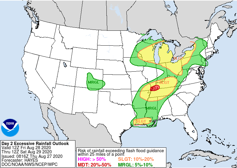
The Weather Prediction Center of NOAA has the eastern fringe of the metro area not far from a “slight” risk (Level 2/4) of excessive rainfall Friday. While this is more likely to be directed into Louisiana, it’s entirely possible this sets up closer to Houston. So, we just want you to be aware of the risk of some locally heavy rainfall tomorrow. Thankfully, we didn’t see much of anything during Laura’s passage, so we have a good amount of room to absorb any rains.
As of right now, Eric and I are intending to take tomorrow off as a necessary recovery day. However, if it appears the rain risk will become more significant, we’ll chime in with an update. In the meantime, have yourselves a good evening.

Get some well deserved rest!! Thanks again for the no nonsense wisdom.
Thank you!! I have recommended you to so many people including family and friends in Louisiana who followed your Laura posts. We are very fortunate to have you as a trusted weather source. All science, no drama!
Found this blog during Harvey. It was the only place I could find straightforward, useful information at the time. Been following since and very appreciative for the effort y’all put in to making this site so helpful and accurate.
Thank you both so much for keeping us informed. Space City Weather is the best! Please get some sleep!
Wow, these are incredibly sobering photos and videos. Thank you so much for compiling this informative summary of the aftermath! Your comparison to Houston makes an eye-opening point, and is an excellent ‘what-if?’ consideration to keep in mind.
Thanks for all the long hours you put into keeping us informed. It was a big help to get straight facts without the hype. You deserve a break.
Thank you again for your hard work, which I can’t say enough. Major love to our neighbors to the east.
Thank you for all that y’all do. I too, found this group during Harvey and have been following ever since. I trust y’all and appreciate y’all. Enjoy the day off!
Y’all are the best. Thank you for everything you do.
Bravo. You guys are heroes. Thank you very much.
thank you
Eric and Matt – enjoy a very well-deserved day off. I cant even begin to tell you how helpful y’all have been. You are Houston heroes, seriously.
Thank you guys so much for the great weather reports you always provide and for the possibly life-saving details you gave us during this entire Marco/Laura chain of events. All of your scientific explanations of the many factors that cause, create and direct these storms are very easy to understand and give us much more confidence in our decisions (we live in Galveston, but evacuated to Houston). Thank you!!! You deserve a day off…so I hope there won’t be too much rain tomorrow.
Once again, you guys pulled us through. Thank you so much for your hard work and all of the information. Those photos and videos were something else.
You guys are my first source for storm info. Thank you so much! Question – Calcasieu Pass looks tiny and this storm was gigantic. Surely landfall encompassed an area significantly larger than the pass. How could landfall at the pass mitigate storm surge so much and why would only 5 miles west make a difference?
The surge is always greater to the east of the landfall than the west. The east side has winds from the gulf pushing water onto land. The west side has winds from land pushing water to the gulf. There is a general surge brought by the storm affecting both sides for miles on either side of the eye but the east side is stronger.
Great job, guys.
Your coverage of Marco and Laura should be embossed and hung in a Weather Museum above Al Roker’s glasses… Seriously well done gents. Cheers!
Thank you guys. It so good to have facts, data, and honesty during storms like this one.
Guys, I really, really appreciate what you do with the blog. Thank you.
However, given what you said about impacts of a similar storm on the Houston area, what’s your advice to prepare for a similar storm? Aside from head inland and west?
Thank you so much for the time you spend on this. We really appreciate to get the news without the hype.
Thanks for your careful work keeping us informed. We needed to see these pictures. Get rest!
We, in Houston were so very lucky. Will we be next time? It’s coming, we just don’t know when. Thank you for the excellent, sensible coverage of Hurricane Laura.
Thank you so much for all of your hard work! You are the ONLY place I trust for my weather report!
Could you expand your coverage to all of Texas. Or, at least the Fort Worth Dallas metroplex where I live. We really need this kind of service. Everyone in Texas does. Your coverage of this event is really off the charts, above and beyond. Great Work.
The devastation in Cameron is tragic. Could the helicopter view be misleading? A prior hurricane (Rita?) nearly wiped out Cameron. Only a few hundred residents returned. So some of those empty slabs may have been empty for years.
Sally: This is a good point. It’s entirely possible. I’ll never forget driving the Mississippi coast for the first time in 2011 and seeing the empty slabs still there post-Katrina.
A quick review of before and after aerial/satellite photos should tell.
Great coverage. Thanks so much. Enjoy a well-deserved day off.
I don’t do twitter. sure wish the pix were in a more universal context.
Don’t need to “do twitter”. Just click on the links and you can view.
To give you a idea of the reach of the storm. A good part of Montgomery county is without power. Entergy is the primary electrical provider and most of their plants are based in Louisiana.
I’m hearing that we should stand by and keep our Hurricane supplies ready for what’s coming our way next????
That’s excellent advice because we’re coming into the peak season now. We need to keep our eyes on the tropics as we go about our day, and be prepared in case a disturbance looks aimed to come into the gulf. It’s nothing to be alarmed about, but it is something to take seriously. This is the reality of gulf coast living and one of the reasons why that 3000 sqft house in Kemah only costs $250k.
There are a couple of “invest” way out in the Atlantic but they do not look particularly impressive. There is also a cluster of storms off the Yucatan but the models do not show any development.
This time of year it is always best to be prepared. Remember, Harvey spun up in just a few days!
I am quite impressed the “all concerned” with forecasting the track of Laura was able to pinpoint landfall to such an accurate degree, especially with the addition of Marco. Good modeling? Good interpretation of the modeling? A little bit of both, maybe.
Also, buried in one of blogs a few days ago, Eric (maybe), went out on a limb and mentioned the storm could hit 4 or 5. I believe at the time Laura was still a TS. A few wrote that maybe SCW was going a bit sensationalist. I thought the same thing but didn’t make a comment.
Perhaps Eric (maybe) can enlighten us on what he saw that led to his spot on clairvoyance.
Thanks again for being the most reliable “go to” site for Houston weather. If I don’t see it here, then I don’t believe it!
Thanks for the solid no-nonsense coverage over the past several days and for explaining the reason for all the photos. It really brought home what we would in for if Galveston takes a direct hit. Scary. You definitely deserve a long weekend!
Regarding Houston needing to be ready, I could not agree more! A five story apartment complex was just built not far from my house in West Houston and the framing is all WOOD. Go to Florida, and their houses are made out of cinderblock even in west Orlando. That’s why you don’t see the devastation in FL like you do here.
Thank you, gentlemen! Get some sleep!
You guys are amazing!!! Thank you so much and get some very well deserved rest!
You both are so amazing. I couldn’t get through the hurricane season without you. Thank you for doing this for us.
Enjoy your day off!! You both deserve it! Thanks again for getting us through the last few days! Continued prayers for our friends to the East!
Thank you for all your hard work. Hope you can get some well deserved rest on yr day off.
Thank you for all of the hard, intensive work you both put in to keep us informed.