The near-term forecast for Houston is not great, with on-and-off rain chances likely throughout the weekend and persisting into early next week, along with muggy weather. But none of these rains should be too extreme. And by the middle of next week the forecast begins to look markedly better for us after a long, long summer.
Friday
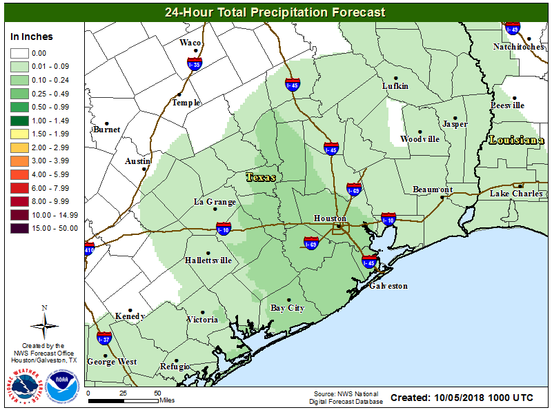
The radar remains largely quiet this morning, with a few rain showers sprinkled offshore. Conditions should be similar to Thursday, with partly sunny skies and scattered showers. As the forecast map below suggests, where rain does fall today it should be fairly moderate in nature, measuring only a few tenths of an inch.

Unfortunately, it will be another warm and humid day, with high temperatures pressing up near 90 degrees, and likely hitting that mark under full sunshine.
Saturday
Another day with partly sunny skies, scattered showers, and warm temperatures. However, if you have outdoor activities planned on Saturday I’d be fairly optimistic at this point as forecast models indicate we’ll see some slightly drier air aloft. I’d have a plan for spotty showers that may pop-up, but as of now it does not appear likely that we’ll see too many prolonged showers over the Houston area.
Sunday
The second half of the weekend, however, looks somewhat wetter. Conditions in the upper level of the atmosphere should favor rising air, which in turn will allow moist air nearer the surface to do its work—form clouds and deliver rain showers. Probably at least half of the metro region will receive rain on Sunday, but amounts should generally be below 0.5 inch where rain does fall. With a few more clouds, and more widespread rain, we can probably expect highs to only crest in the upper 80s.
Monday and Tuesday
Monday should start off mostly sunny, and we don’t expect widespread rain during the day. However, low pressure appears likely to influence rain chances during the overnight hours and into Tuesday, which should lead to a healthy chance of showers and thunderstorms during this period. I would spitball accumulations in the 0.25 to 1.0 inch range for Monday night through Tuesday, but it’s hard to have too much confidence. Overall, we don’t anticipate any significant problems from these rains, but if you see lightning please shelter accordingly.
Wednesday, the tropics, and beyond
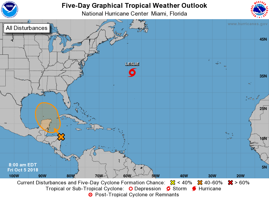
The National Hurricane Center has raised the likelihood of development of a tropical system approaching the southern Gulf of Mexico to five days to 60 percent. The forecast on the center’s site looks pretty ominous:

But really, we don’t think it will be for Texas. First of all, none of the global models really develop this system much beyond a tropical storm—if that. Moreover, the upper-level pattern in the atmosphere should pull this system northward next week, toward somewhere between the Louisiana coast and the Florida panhandle.
If that happens, and for now we definitely believe it will, Houston should be on the receiving end of some drier air moving southward, on the western side of the storm. Yes, you did not misread that. Drier air. Beginning some time on Wednesday, or thereabouts, we should start to see some more pleasant evenings, with lows for inland areas in then upper 60s, and lower 70s along the coast.
But wait, there’s more. Being on the backside of this system should also help pull a cold front down into Texas, and Houston, by Thursday or Friday of next week. I’m hesitant to be too bullish on this given how long we’ve waited for this, but as of now I’d say there’s definitely a better than 50-50 chance that next weekend feels really nice in Houston, with drier highs in the 80s and lows in the 60s. That’s not cold, but it is typical for our first fall front. And I certainly won’t be complaining about it.

Drier, cooler air won’t have me complaining either. It’s been a long wait, and anticipation will make the arrival of a front all the sweeter.
I have a question about seasonal temperature predictions. For years, the CPC has almost constantly had our area (if not much of the country) shaded orange, meaning we can expect above average temperatures. At what point do they re-define average? If we’re nearly always above the average temperature, wouldn’t the average be slowly creeping up?
If I remember correctly, they run on 30 year averages. At the end of the decade, they reset the average based on the past 30 years. Right now, we’re on the 1981-2010 average. After 2020, we will be on the 1991-2020 average.
Eric, what are your thoughts on that disturbance around Costa Rica (on the Pacific side), which models have jumping over to the gulf?
You have no idea how different my life is not having anxiety about things in the Gulf that you say not to worry about. Thank you for your extremely positive impact on my mental health. You’re better than any shrink would have been <3 <3
“But wait, there’s more.” Is that your Ron Popeil imitation?
One could better than adjusting 30-year average at the end of each year. Just do a regression to find out what the current normal might be. Or also give figures based on a 10-year average.
would love to hear your opinion on the Hurricane Sergio – Newsweek put out a model that has it coming straight thru Houston…………
Seriously? Paul is that you and alter ego # 49?