After a couple of modestly drier days, Houston should now return to a wetter pattern over the next week or so as high pressure moves off and the upper-level pattern in the atmosphere becomes more conducive to rainfall. Today, we’ll also discuss some potential tropical activity in the Gulf of Mexico, as well as hints of the region’s first real cold front about eight to 10 days from now.
Thursday
The radar is clear this morning, but with atmospheric moisture levels at reasonably high levels we should see at least some scattered showers this afternoon as temperatures move into the upper 80s. Skies should be partly sunny for what will feel a lot like yet another humid, late summer day.
Friday, Saturday, and Sunday
The weather for this weekend looks unsettled, but not overly stormy. While atmospheric moisture levels will be fairly high, there is no strong forcing for rainfall. So while there will be a healthy chance of rainfall each day (we think 30-50 percent for inland areas north of Interstate 10, and 40 to 60 percent for areas closer to the coast) we don’t expect particularly high accumulations.
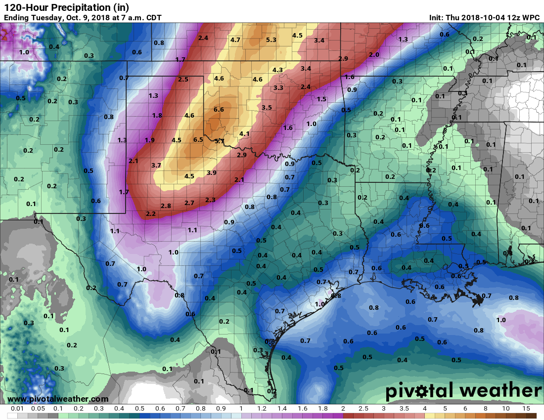
Most of the area will probably see between 0.5 to 1.0 inches of rainfall, with the usual outliers in terms of higher localized amounts. High temperatures will probably range from the mid- to upper-80s depending upon the extent of cloud cover (we’ll see some sunshine), and nights will be sticky, and in the mid-70s.

Tuesday and Wednesday
It looks like there is the potential for more organized storm activity during the early part of next week, especially later on Monday and Tuesday. This may be a period when we see more thunderstorms, and accumulations of 1 to 2 inches of rain. Or it may not. It’s just that the dynamics for this kind of activity appear to be more favorable for storms early next week than over the weekend. We’ll watch this for you.
Tropics
Expect a lot of light and noise over the next few days as a large area of low pressure moves from the Western Caribbean Sea toward the Gulf of Mexico. The National Hurricane Center gives this system a 30 percent chance of development into a tropical storm or hurricane over the next five days.
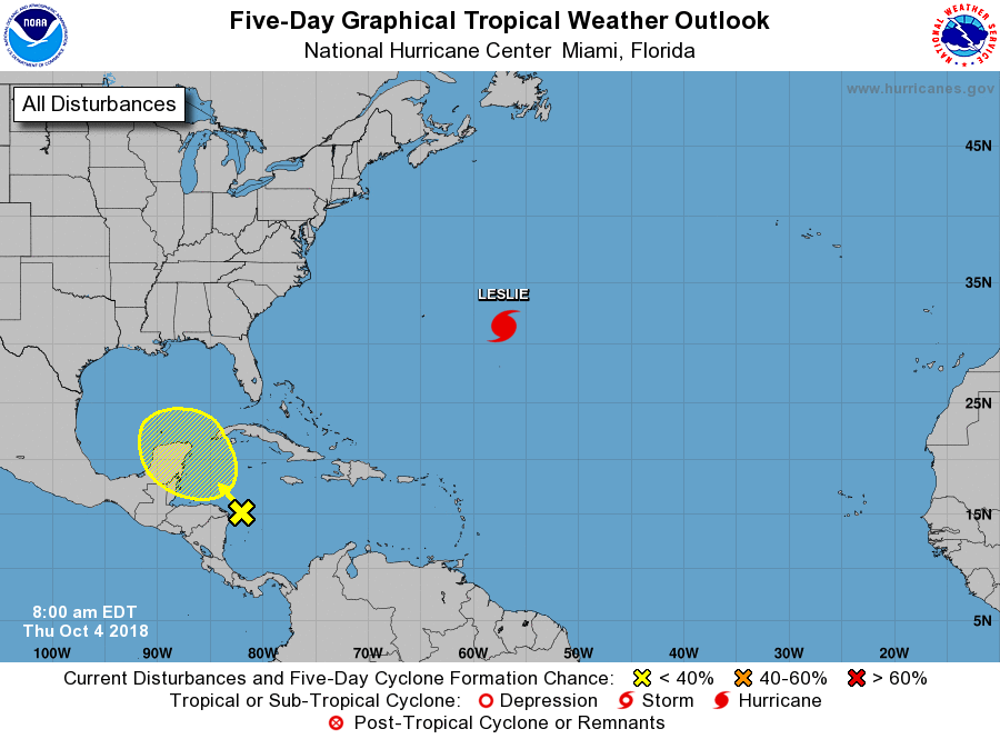
It is not out of the realm of possibility that this system tracks toward Texas over the next week or so, but the historical odds are against it (just one hurricane has struck the state this late in the year in the last 150 years, Jerry on Oct. 16 in 1989). Moreover, most of the modeling guidance shows a large, upper-level low pressure system over the state forcing anything that develops northward, toward Louisiana, Mississippi, Alabama, or Florida. The bottom line is that we’re watching this system, but we’re not particularly concerned. And neither should you be. If that changes, we’ll be sure to let you know.
Cold front
For really the first time this year, both the European and GFS forecast models are showing a cold front in the 10-day forecast (about nine days from now). Both of these operational runs have decent, but not overwhelming support in the ensembles so while this is a hopeful sign—theoretically the front could roll into the region in time for next weekend—it’s not something we’d count on at this point.
Light and noise!!! Hahaha
That’s exactly what I will say to my 5 year old who is currently fascinated with thunderstorms and asks me every morning lately ‘if there is going to be one today?’
Hopefully not today! My lawn needs to dry out a little bit so I can mow it before … more rain comes.
Is, “light and noise” related to sturm und drang?
Sounds like cooler weather will arrive just about the time we travel to Northern Wisconsin to visit our grandchildren. Haha! That’s the definition of ironic ☺️
Cypress/Tomball got a nice .68″ last evening, thank goodness fast moving.. .So TIRED of rain and gloom… and definitely tired of watching the dam tropics (as I am sure you guys are too) … thank you for keeping us sane on the Gulf Coast
We promise to keep you sane as long as we can remain sane ourselves. That first front would certainly help in that regard.
I agree with you about watching the tropics! Not to mention our region is mosquito heaven..To me, this year seems especially bad in regards to unrelenting heat and humidity..I am more than ready for summer weather to say bye, bye…I am seriously thinking about moving northward, out of Texas, so I can enjoy Fall again..
I hear you – I’m considering retiring in 3 years time back to my hometown, Albuquerque, New Mexico! Dry weather just sounds soooo good after Alicia, Allison, Ike, Tax Day Floods, Memorial Day Floods, and Harvey! I’m tired of nervously watching the Gulf every August and September!
I am from around Lafayette, LA (been here 27 years) and we NEVER flooded like it does here… I’ve seen Cat 3-4 in my life….we had to worry about boarding winds and generators for wind damage and power outages, but we never (family still does not) worry about the flooding…Houston needs to do something fast !!!
AMEN! I live in the Cypress area and my subdivision had never seen flooding in recorded history UNTIL the Tax Day floods and Harvey (we aren’t even in a Flood Plain). The storms seem to be changing in intensity and duration – add into that mix all the new construction that is going in out west of us due to the Grand Parkway and . . . I’m afraid the flooding will be come common place – Scary! (and yes, I now own Flood Insurance!)
Dogfoodlady: I too am in Cypress.. Tax Day was 2″ from my door and then Harvey 2′ in the house.. our neighbors had been there 40 and 50 years and NEVER seen flooding like that. They built a new subdivision in a pasture that used to hold our excess water. Well with that filled in with concrete… here came the flooding… Grand Parkway has flooded an uncle’s house 3 times (Tax Day, Mem Day and Harvey) .. the way the water is funneled it destroyed ranch land and farm land, not to mention numerous houses. and barns… We always had flood insurance… I learned in Harris Co, it’s not if you flood it’s when
Let’s see here… when a ball team gives up three runs in an inning, they change out the pitcher. When a hockey team gives up three goals on three consecutive shots, they change out the goalie. When the first cold front of fall fails to show up by mid October, we therefore…..
No pressure, Eric….
That was me above. NAme got cut off.
Everyday, for the last 3 weeks, I wake up hoping this is the day that Eric says a cold front is coming 100% no doubt, and it will be super strong so get out the jackets. I just hope it doesn’t take another 3 weeks.
Thank you, Eric, for your even-handed forecasts. I’m leading a conference on a Western Caribbean cruise Oct. 13 and am wondering about that system in the Caribbean, and if I should be concerned?
Traveling to Baton Rouge on the 11th, is this possible storm something that I will have to worry about, or will it have passed by then?