Based upon an average of temperatures from 1980 through 2010, which establish so-called “normal” temperatures for the Houston region, the very warmest time of year runs from July 27 through August 20. During this 3.5-week period the average high temperature at Bush Intercontinental Airport is 95 degrees, and the low is 75 degrees. (The comparable period for Hobby is July 22 through August 22). These are the absolute dog days of summer, with hot, humid days, and warm, sultry nights. However, there are some distinct signs that fall is not all that far away, most notably our shortening days—our 13 hour, 37 minute length of day now is nearly 30 minutes shorter than a month ago at the solistice.
Monday
We don’t have great confidence in the forecast for this morning, however we do expect less coverage in showers and thunderstorms than the region saw Sunday, when a few areas south (hello Pearland!) and southeast of the city saw up to 1.5 inches under fairly strong storms. Rain chances today will probably be less than 20 percent, with isolated, mostly short-lived storms. Highs will likely climb into the mid-90s with mostly sunny skies. Lows Monday night will only fall into the upper 70s.

Tuesday and Wednesday
Rain chances will be a little higher on Tuesday and Wednesday, with a bit more of a disturbed upper atmosphere helping to force some lift at the surface. I’d peg rain chances at both days around 40 percent for areas between Interstate 10 and the coast, and 30 percent for inland areas. On average, accumulations will be less than one-half an inch, but there probably will be some outliers that pick up more. Highs in the mid-90s.

Thursday through the weekend
Houston will fall into a more typical summer-time pattern at least through the Sunday period as the region gets squeezed between high pressure to our northwest, and low pressure to the east. This should lead to highs in the mid-90s, with mostly sunny skies, and a small chance of afternoon showers setting up along the sea breeze. If you have outdoor plans for the coming weekend, tentatively, they look pretty good to go.
Tropics
The National Hurricane Center is citing the area from the eastern Caribbean Sea to the Florida Peninsula for potential development over the next five days. While this is likely to make for a wetter pattern over Florida this weekend, the most likely path for whatever—if anything—that develops will be toward Florida, and then toward the northeast. In other words, the western Gulf of Mexico should have no concerns.
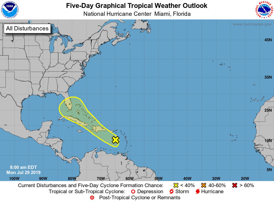
With that said, there are signs that the “African wave train” is about to come online, when we begin to see the classic August and September pattern of tropical storms forming from waves moving off of Africa, into the Atlantic Ocean, and traversing westward toward central and north America. We’ll be watching for you.
I wonder, with generally a warming atmosphere, how soon we’ll start to see this period widen in duration and, potentially, shift more towards the autumnal equinox?
Oh, goody. My favorite part of summer is starting—the “two months of vague unease wondering if we will we have to evacuate this year” roller coaster.
This will be my 41st summer living in Houston, and the older I get, the more nervous and less chill I get about hurricane season. I don’t know if I’ll be able to do many more of these—it feels like it’s getting harder rather than easier.
You took the words right out of my mouth. The anxiety this causes me every year (not to mention when we actually get hit) is so not worth it.
Well, this is summer 39 for me and the feelings are the same. I have to say, the night of Harvey was the most terrifying of my life even though our subdivision (just barely) didn’t flood. With my retirement planning well underway I can say it is unlikely to be in Houston or anywhere on the Gulf Coast (more likely TN or NC).
That being said, there could be an interim period of a few years while I’m waiting for family to get where they say they are going, in which case that time will definitely be spent north of 59 or I-10 to avoid evacuations (plus the fact that parts of Clear Lake/Ellington are getting pretty crappy these days).
No rain in the Jersey Village area in weeks. 🙁
I’ve lost hope that my corner of Katy will ever get rain again …
Be careful what you wish for…. oh so careful.
Evil laughter: gets louder and louder
Eric – Thanks for the 2.3″ of rain this weekend. The 1.1″ on Saturday was impressive because it fell in a little over 30 minutes, though it did kick DirecTV off air. The 1.2″ sometime mid-day Sunday was well timed since I was at a lunch on the other side of town.
Only problem is I’ll be cutting thick grass again this Saturday.
Technical Question:
NHC detailed forecast includes some significant tropical waves (with convection), so at what point do these make it to the map with projections? What has to occur for it to be moved from a “discussion” to putting it on the map?
Thanks
Well, all I can say is, you almost ruined my Sunday Fun Day at HYC to welcome all our new members with the storm that pushed through down here on the bay!! 🙂 🙂 LOL LOL
BUT, the good news is, it turned out magnificent and we had a pool full of folks enjoying the beautiful day once the nastiness went away! So, all is well!
Google weather shows humidity dropping into the 50-60% range Thursday-Sunday. Shouldn’t that mean a really pleasant weekend, with noticeably lower humidity?
(Relative) humidity, without context, is pretty meaningless. For example, an ambient temp of 96 def F with a 78 deg F dew point, calculates out to a RH of 56%. Personally, and I think most would agree, this would not be considered “pleasant”. Take a look at dew points; that will tell you a lot.
Starting to think my house on the westside has a permanent high pressure system hanging out right overhead. I miss rain.