Over the next 7-10 days, the weather over Southeast Texas will probably agitate those of us that like stability in our seasons. We should see a bit of a roller coaster ride unfold over the area. Let’s jump into details.
Today
Watch out for some changeable visibility this morning. There will be some dense fog near the coast and patchier fog inland through the first part of the morning. We’ll shift to mostly cloudy skies this afternoon, though fog could continue near the bays and coast. There should be a few showers around this afternoon, along with perhaps a rumble of thunder. Look for temps to push toward 70 degrees.
Tonight and Saturday
Our much discussed cold front will make its grand appearance for most us while we’re sleeping. The evening should feature low clouds, humidity, and some drizzle or showers. No serious disruption to Friday night plans here. The main front should sweep through the area from northwest to southeast from about 1 AM through 7 AM. With it, some showers, perhaps a few thunderstorms, and then a big change.
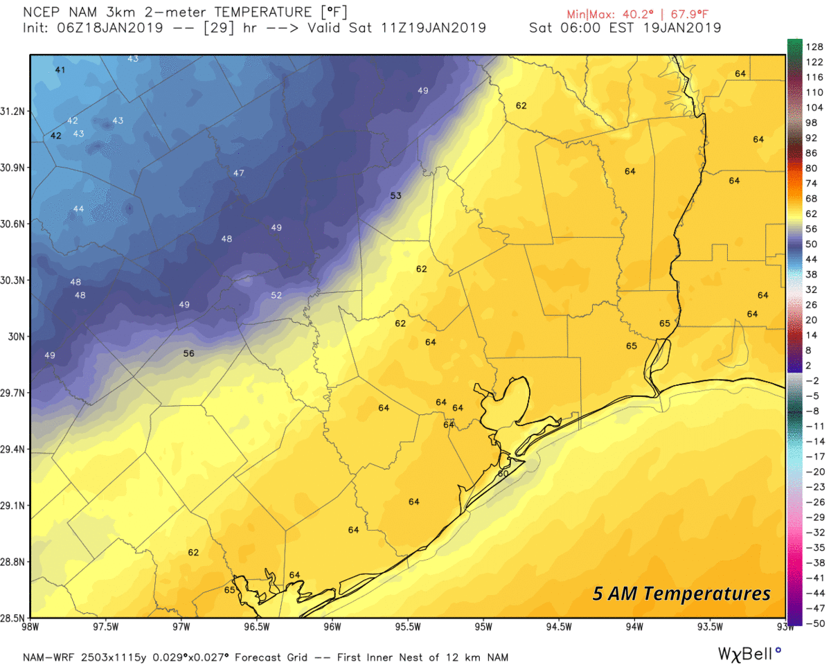
We’ll start the day in the 60s around 5 AM and head toward midday with temperatures in the 40s. We should hold in the 40s for most of the afternoon. With it should be a 15 to 20 mph wind, gustier near the bays and on the coast. It will feel like winter.

Sunday
For those running in (or attending) the Houston Marathon, we continue to see improvement over where things looked earlier this week. Winds will slacked to 10 mph or less I think, and we should see temperatures in the mid-30s at race start. Look for us to warm up to about 40-45° by midday and near 50° or a touch warmer during the afternoon. All of this will occur under sunny, blue skies.
For Sunday night’s lunar eclipse, as Eric discussed yesterday, it looks perfect: Clear and cool with temperatures dropping into the 40s and perhaps some 30s in a few spots.
MLK Day
For Monday, look for more sunshine. Clouds should begin to increase as the day wears on, but all in all it looks great. For those attending Martin Luther King Jr. parades, it looks pleasantly cool, with temperatures near 50 degrees, warming into the mid-50s. Monday afternoon should see us approach the low-60s with enough sunshine.
Rest of next week & discussing the polar vortex
We’ll likely warm up further on Tuesday ahead of our next cold front. That will push through Tuesday night into Wednesday morning, leading to colder weather on Wednesday and perhaps Thursday. Look for mid-to upper-60s Tuesday, followed up by low-50s on Wednesday. Morning lows may sneak back into the upper-30s Wednesday and Thursday mornings. Additional one to two day swings of warmer, then colder weather are likely in quick succession into the weekend the week of January 28th.
All this will be occurring as some substantial changes in the hemispheric weather pattern take place. Most of you have heard of the polar vortex, as the media has tended to hype it in recent years. It’s legitimate and something we discuss in meteorology, and it’s always there, somewhere. It’s not some synonym for cold; it’s a real thing. Typically, the polar vortex is by the North Pole, keeping the coldest air in the Northern Hemisphere mostly where it belongs, in the Arctic and Polar regions. But every so often, the polar vortex gets disrupted, dislodged, displaced, or split, and typically that leads to interesting weather somewhere where more people live. That’s exactly what looks to unfold over the next couple weeks.
The polar vortex split has opened the floodgates to Arctic air, far more active storm track in Midwest/Eastern US and Western Europe. Details: https://t.co/xiZ5APYpNd
— Andrew Freedman (@afreedma) January 16, 2019
Andrew Freedman over at Axios did a nice job summarizing how this occurs and what it means, so I won’t rehash too much of what he said. In a nutshell, when a split like this occurs, pieces of the polar vortex get forced into the mid-latitudes, often into North America and Europe. As you would expect, since some of the coldest air in the hemisphere lies below the polar vortex, some of that cold comes with those pieces into the mid-latitudes. Of course, it modifies a bit, but it’s still extremely frigid. What often happens in these scenarios are “blocking” patterns, where relatively warm ridges of high pressure in the upper atmosphere form over the Arctic or Alaska or Greenland. As you push warmer air into those places, the cold that’s typically there has to go somewhere, and usually that’s south into the U.S. or Europe or Asia.
For us here in Texas, this change in the weather pattern likely means that we still have some legitimate winter in front of us. While we’re far enough south that we don’t actually see the polar vortex itself here, these types of patterns often drive cold, Arctic air masses and blue northers into Texas. While we can’t point to anything specific at this point over the next 2-3 weeks, all the signals and signs are there saying we should have at least a few days of some pretty darn cold weather here in Texas. When and for how long? Stay tuned.
A very clear and informative explanation of the polar vortex! Thank you for taking the time to summarize how that really works and what its effects might be for us.
Agreed.,Excellent. But will have to read 2 or 3 more times to get it all!
Ugh. I grew up in Wisconsin and one of the main reasons I moved to Texas was to escape the cold. I’m ready for the 90s to return!
After almost 40 years here, I’m ready to move back up north (or better yet the mid-South) to get away from our annual 100 days of 100 degrees. Not to mention the annual 100 yr floods.
Blackhawks Fan – we are aware. You constantly post this. I moved here from Chicago and very much prefer Houston weather. But if you are miserable, by all means please move and find your happiness😊
Just waiting for retirement – – or that closed door meeting with HR (please,please,please). Same thing.
Thank you! Everyday this guy has to give us a life story about what ‘real cold’ is or how unhappy he is down here. No one cares nor values your opinion. Please move back.
What does this guy expect? Does he want us all to shout to him in amazement, “OMG YOU ARE SO TOUGH! YOU’RE RIGHT, OUR PERCEPTION OF COLD IS INVALID BECAUSE YOU HAVE SEEN LOWER NUMBERS SO WE ARE JUST SO WEAK COMPARED TO YOU!” Get a grip dude, I am coming here for weather not for some old timer to “back in my day” me.
I agree Blackhawks Fan, I’d like to move somewhere that has snow. The Texas summers are much to brutal and winters to mild and Harvey killed most of the love I still had for H-town weather. That doesn’t mean I want Canada weather I’m not a masochistic!
lol this isn’t Wisconsin cold
How cold do you expect it to get Saturday night-early Sunday morning this weekend?
About the same as the average HIGH temperature this time of year where I grew up.
Speaking of where I grew up, forecast low Monday morning -6F, Forecast high Monday 12F. Let’s not hear any complaints about it being cold here this weekend.
Well, it’s mighty cold here for folks who don’t have anything warmer than a sweatshirt hoodie to send their kids to school in, or who have a crap electric heating system rather than a “proper” gas furnace. eyeroll
On average mid-30s, some risk of upper 20s to low 30s up north away from The Woodlands toward Conroe or northwest toward Brenham. Milder (upper 30s) south and east toward the coast.
Matt, I guess Eric has removed himself today so he can begin his carbo-loading and getting himself psyched up? 😉
And shop for cheap, discardable clothing.
HA, absolutely. And I’ll even down some carbs for him!
With all the fog hanging around longer, does the rainfall amounts go up with the front tonight?
Nope. Fog in this case just indicates that warm air is crossing a cool surface. The ground/bays/Gulf are cool, and the air mass is one of the warmer ones we’ve had in a few weeks. Rain totals can’t be derived from that. Rain totals tonight should be around 0.5″ (or less in many cases).
Thank you for your response. I wish you guys all the best.
Are folks planning to cover plants Saturday morning or are you going to skip it? I’m right around I-10 and Beltway 8.
we covered the most sensitive ones, like our cacti and some other spring plants
thank you for report…any idea how bad is the East storm going to be? We have family in Virginia and New York