On Monday the state climatologist, John Nielsen-Gammon, called my attention to the visible satellite image page for the upper Texas coast. I’ve attached a snippet below, showing the period roughly from 8am to 1pm on Monday. If you look just northwest of Galveston Bay you can see the cooling stack plumes show up from some of the largest refineries in the Ship Channel. These facilities are leaving bow wakes in the low-stratus cloud layer.
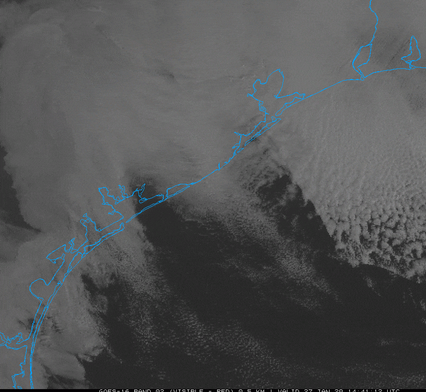
So what is causing this? The cause is weather-related, John speculates it is likely a combination of the following factors:
- A well-defined temperature inversion at the top of the low cloud deck.
- Weak stability and strong wind shear above the inversion that would enable waves to be trapped horizontally on the inversion rather than propagating upward and away.
- A sufficiently shallow stratus layer that a bit of downward motion would be enough to temporarily clear out the clouds.
- A sufficiently large volume of heated air rising from the plants to produce strong enough wakes to be seen.
In any case, the weather on the Texas coast is rarely dull! Now, on to the forecast.
Tuesday
A diffuse mass of mostly light to moderate rain showers will move slowly from west to east across the Houston area today. The showers, with possibly a few embedded, stronger thunderstorms, will probably persist through most of the daytime hours. Most parts of the region should see between 0.25 and 0.5 inches of rain throughout the day. The combination of clouds and rain will likely limit daytime highs to the upper 60s for most of the region. After sunset, a cold front will sweep through Houston to help dry the region out. Conditions tonight will be breezy and colder, dropping into the 40s.

Wednesday
We should see some clearing skies on Wednesday, but the combination of northerly winds (perhaps gusting to 20mph or so) and the front should limit high temperatures to around 60 degrees. Lows Wednesday night should again drop into the upper 40s for most of Houston.
Thursday and Friday
Partly to mostly cloudy weather will return to end the work week, with a pair of chilly days in the upper 50s to 60 degrees, and nights in the 40s. Both days will probably see some scattered showers, but accumulations look pretty slight for the most part, perhaps measuring in a tenth or two of an inch of rainfall. A front will eventually follow the rain, and this should lead to some clearing skies by Friday afternoon or evening.
Saturday and Sunday
Our confidence in nice weekend weather is increasing. Conditions look pleasant for the Houston area, with highs in the mid-60s on Saturday, and 70 on Sunday. I don’t think skies will be 100 percent clear, but there should be lots of sunshine.
Next week
It looks like we’ll see a warming trend on Monday and Tuesday, with highs probably somewhere in the 70s, before a stronger cold front arrives to bring chilly mid-week conditions. Does that mean nights in the 40s? Or even the 30s? We’ll have to wait for those kinds of details.
Eric, do we have enough data yet to contextualize this almost-over January in terms of its overall temperature compared to a “normal” January?
Maybe it’s just the confirmation bias in my head talking, but man, it feels like this has been the warmest January I can remember ever going through—at least in terms of number of days where the daytime temps have been parked in the 70s. Based on my usage graphs on the power company’s web site, I’m guesstimating my January electrical bill is going to be about $60-80 above where it’s been the past few Januaries thanks to how much I’ve had to run the air conditioning, at least.
I’m not really seeing it, but glad to be contributing to the satellite imagery! (At least nothing is on fire in the image….)
Northwest “corner” of Galveston Bay, look for the little curves as the main clouds start to break. Most Noticable at 2s in, but when it resets you should see the beginning of it
I liked the really large waves heading from west to east better…
Yeah, you can also see little white dots at the center of those curves which I assume are the plumes of the stacks themselves.
So am I looking for something white or something dark?
At least you guys are referring to them properly as “cooling tower plumes” and not “smoke” like one FOX26 morning person during the small fire they had at Pasadena Refining a few years back. Arrrgh… you think the media would have someone familiar with the petrochemical industry commenting on it. Or at least someone who at least passed a college chemistry class.
It took me a while to see it and I am pretty sure its the Marathon refinery in Texas City. I work in Texas City every day, in the city not at the plant, and there were a few days last week that the stacks seemed especially active.
Yeah I see it. Interesting and crazy seeing weather play a part in something else. Thanks for the imagery and explanation guys😀