Good morning. This week will offer something for everyone. We’re going to start off with some of this year’s warmest weather so far, with inland areas of the region likely to hitting 90 degrees this afternoon. Then on Wednesday morning a cold front will push into the region and stall along this coast. This will destabilize the atmosphere and lead to a prolonged period of on-and-off shower and thunderstorm activity from Wednesday through Saturday.
While there is no one focus for particularly heavy rainfall during the second half of this week, there is the potential for 1 to 2 inches each day and night, and over time this may lead to some street flooding. For this reason we are issuing a Stage 1 Flood alert for the period from Wednesday through Saturday afternoon. This means we are likely to see nuisance street flooding, for the most part. If the data changes, we may need to adjust the alert warning, but for now we expect Stage 1 to cover things.
Monday
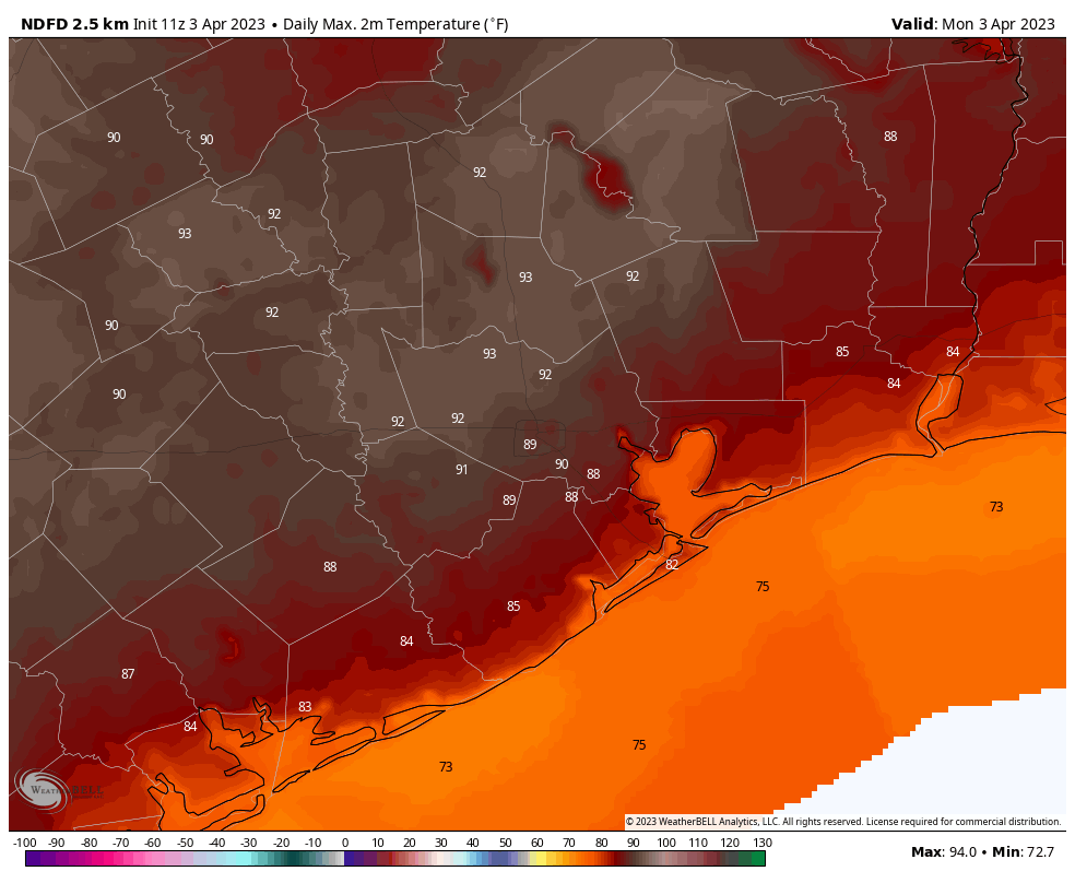
Are you ready for some heat? With high pressure in place and a warm southerly flow, temperatures will warm into the upper-80s for most of the region. Whether you reach 90 degrees will depend on how far you are from the coast, and the extent to which the Sun emerges from behind the clouds today. Most areas inland of Interstate 10 have a good chance of hitting 90. Winds will be out of the south at 10 to 15 mph. Clouds return this evening, with lows dropping only into the mid-70s.
Tuesday
This will be another warm and humid day, although mostly cloudy skies should limit high temperatures to the upper 80s. Winds out of the south will be noticeable, perhaps gusting to 25 mph. Expect another warm night.
Wednesday
Although the timing is yet a bit uncertain, a cold front will reach the Houston metro area during the late morning hours or around noon on Wednesday. It looks like this front, with a line of showers and thunderstorms, will push just offshore and then simply stall for a few days. This will open up the region to a series of disturbances through the end of the week. Temperatures will fall into the upper 60s, roughly, as the front passes, with overnight lows dropping to around 60 degrees.
Wednesday night through Saturday
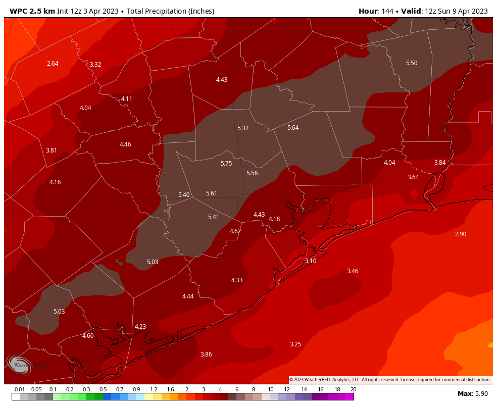
The next three nights and days will bring an elevated chance of rainfall. Totals will vary widely and are as yet uncertain, but most locations will probably see 3 to 6 inches of rainfall, with isolated areas seeing more. At this time it looks like rain accumulations will be highest in the tier of counties just inland from the coast—Fort Bend, Harris, and Liberty Counties. We are issuing a Stage 1 Flood Alert at this time because our region’s dry soils should be able to handle rainfall over a three-day period. Some street flooding is possible, certainly, especially toward the end of the week as accumulations mount. We’ll be watching the situation closely in case we need to elevate the flood alert level.
In terms of temperatures, we are likely to see highs in the upper 60s through Saturday, with lows in the upper 50s to lower 60s. We won’t see much, if any, sunshine until Sunday.
Sunday
Fortunately for those concerned about Easter Sunday, it does look like this weather system should move off to the east by Saturday afternoon or night. That’s cutting it close, but for now it looks as though rain chances will be low on Sunday, with the possibility for partly sunny skies by the afternoon. For now I’ll ballpark high temperatures around 80 degrees, with moderate humidity.
Next week
Most of next week is likely to see highs in the low 80s, with lows in the mid-60s. Humidity levels do not look unreasonable for mid-April. We should have several days, at least, to dry out after rains this week.


Where does Hurricane Ike fit on the flood scale?
Imelda was a Stage 3 event with 40″+ of rainfall. Ike was almost 19″ of rainfall in a 48 hour period at its heaviest location. I would personally put Ike at a Stage 2.
Imelda was a Stage 5 out east where it rained the hardest (see SCW Flood Scale for explanation). In Houston, the damage was relatively minor. I think we got like 9-10 inches of rain from that storm. Just for clarity.
Where I live in SW Houston (not far from Brays Bayou), I honestly don’t recall there being much flooding from Ike. I remember walking around my neighborhood as soon as the winds died down, around 9AM that Saturday (Ike made landfall and moved over Houston late Fri night/early Sat morning), and all the streets were clear and dry. I still live in the same house, and I’ve seen heavy spring/summertime thunderstorms since then that resulted in worse street flooding. Some parts of town fared worse I’m sure, but for where we live, I’d say Ike was a Stage 1 or 2 at most.
Was planning on driving down from Thursday evening from DFW. How concerned should I be?
Just another miserable swamp weather day in Houston. Staying in my air conditioned house until November when you can actually walk outside.
Hey Tim L, Joseph, or TL, how do I determine if there is a capping inversion over metro. I’ve tried studying those skewed T charts but which line is it
Look at temperatures in the upper atmosphere. The warmer they are compared to surface temps the stronger the inversion.
Ok thanks that’s easy
One of the best ways for me to tell if the atmosphere is capped is to look up the current surface map on google. The first link that pops up is from http://www.weather.gov. That is a good one to go to. Winds travel mostly parallel to the contours you see on the map. Right now there is a pretty steady southwest wind over most of Texas which means the atmosphere is most likely capped over Southeast Texas at this moment since alot of dry warm air from the desert mountains in Mexico is filtering into our upper atmosphere. https://www.wpc.ncep.noaa.gov/dailywxmap/
This is where you can go to look at old archives surface maps.
Curious and Friday. My weather app shows 5.1 inches that day in Spring which is a concerning. How accurate do you think this is?
Tornados seem to be fierce this spring; more tornados and more deaths. I wish you would do a comparison of this spring to others.