This storm has been maddening. You have to walk a very fine line between panicking people and providing actionable information. The balance is between the weather models (screaming 5-10″ of rain), the reality that big rain events aren’t that uncommon here, and the fact that people have a recent disaster (Memorial Day 2015) fresh in mind. It makes it difficult to communicate the information effectively. I know a lot of events and even some schools have been cancelled tonight and tomorrow. And it hasn’t rained much around Houston yet today, so people have to be very confused.
Here’s the scoop.
RECAP OF TODAY
The worst of this event was always supposed to be overnight tonight into tomorrow. Recall this morning, I said that most areas would see 0.5″ or less in all likelihood during the day today. Most have.
The good news today has been a very distinct lack of severe weather in Southeast Texas. We’ve managed to get through without any serious issues or warnings. The best parameters for severe weather will continue to exit to our east this evening and any tornado threat overnight will likely stay closer to the Golden Triangle than in Houston.
TONIGHT
The setup evolves tonight. As the best wind shear and parameters for tornadoes shifts east of Houston, a deep plume of tropical moisture will replace it. The amount of moisture available in the atmosphere for heavy rain will resemble something we usually see in June or July, rather than March.
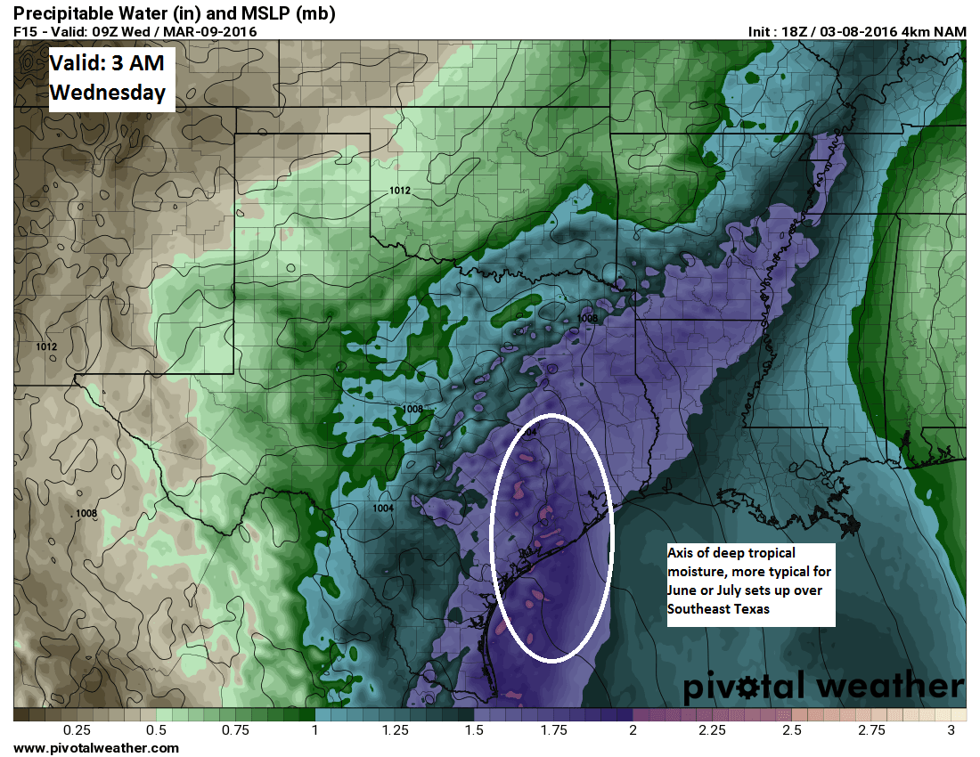
What does this all mean? It means that as we go through the night, we can expect rainfall to congeal a little more. Whether that axis of heaviest rain is just west of Houston or right over the city and points east, I can’t say for certain…this one has been giving me fits all day. But we do know that there will be numerous scattered to widespread showers and thunderstorms, and with 2″ of available precipitable water as shown above, it’s going to absolutely pour wherever these storms do set up.
For informational purposes, here is a look at the short range HRRR model, taking us out to 6 AM Wednesday. It wants to favor areas west and north of Houston for the heaviest rain. Don’t pay attention to the exact specifics here so much as the large area of heavy storms expected to develop. Today it may seem like a busted forecast, but it is coming, I assure you.

WEDNESDAY
We’ll have more details on how Wednesday plays out tomorrow morning, but the general thinking right now is that we’ll be in and out of showers and more localized heavy thunderstorms throughout the bulk of the day. We’ll need a few more disturbances to clear the area tomorrow and tomorrow night before things settle back a bit Thursday.
FLOODING
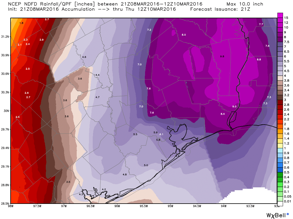
A Flash Flood Watch is posted for the entire region through Wednesday afternoon. I suspect they may extend that tomorrow, depending on how things play out tonight and tomorrow morning. The current official rainfall forecast from NWS is calling for 5-7″ through Thursday morning. I’ve placed the map below. Keep in mind that when all is said and done, this map won’t verify perfectly. Some areas may only see 3-4″, while pockets in or northeast of Houston could see as much as 10 or 11″. This will all likely lead to typically flood prone streets being a pain tomorrow. Areas that only flood in the heaviest rain may experience some issues also by the time all is said and done. The simplest and most clear advice: Plan to go about your Wednesday with some travel headaches. If you can postpone something a couple days, it’s not the worst idea to do so. Never drive through flooded roads…use common sense. And stay tuned into the weather throughout the day tomorrow for any updates (good or bad).
Thanks Matt! For both the no nonsense, and the obviously not wanting to hype anything, just wanting to give us the facts.
Thank you Matt. I appreciate you walking that fine line. Feel like I understand a little more of what you meteorologists have to go through as you interpret data and weigh your words carefully. Grateful to have you and Eric informing (and educating) us along the way… Much appreciated!!
I am curious – do you work for one of the news agencies as their meteorologist? Or are you a scientist? You are awesome, and wondering how you support yourself with this website unless it is a side gig.
Today’s forecast was a bust. Stop with the excuses.
“Recall this morning, I said that most areas would see 0.5″ or less in all likelihood during the day today. Most have.” Most areas got less than 0.1″ of rain. Many got none at all. Heck, my son played his baseball game tonight. Given how you and NWS forecast today, no parent thought the game would be played. That’s bad forecasting with real consequences.
You also said that isolated areas could get up to 2″ of rain. Gee, where are those areas? 100 miles away?
This is the way Texas coastal weather works. Welcome to Houston. Pull the stick out already.
Why are you so angry? You got to play the game!
The most rain was predicted overnight and it rained overnight.
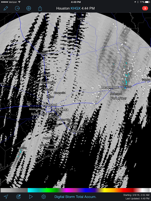
Did you see the radar? There was a TON of rain and we were lucky enough to not get pummeled.
I did wonder why Matt’s post sounded so defensive, but now I know he was bracing for ridiculous angry comments.
Keep up the good work Eric and Matt! You’re still the best and most reliable source for weather.
It’s a forecast, not a guarantee. I have followed Eric (and now Matt) for years and I continue to appreciate the calm and straightforward information. If you simply thought a baseball game wasn’t going to be played, that’s a pretty minor consequence. Our home has flooded three times in 2.5 years – I’m relieved we did not experience that again last night, and I’m thinking of those in north Texas and Louisiana who are dealing with severe weather and flooding.
Plenty of rain in Bellville for the past 2 hours and it’s still coming down pretty hard.
Btw, your clock is an hour behind 😎