As most of you probably know, Tropical Storm Cindy formed in the Gulf of Mexico today. This post will assess the storm’s rainmaking potential, and whether high winds or tides will impact the Houston area. I’ll also discuss why I’m becoming a little more concerned about Cindy.
Track
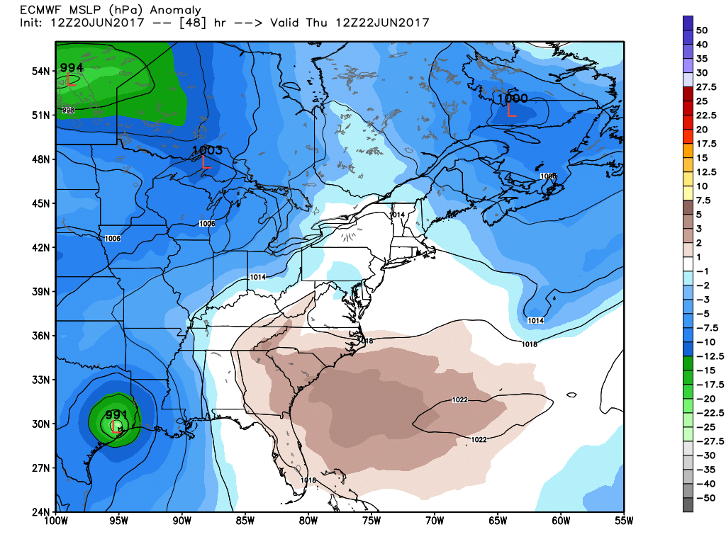
Although Cindy has improved its circulation, it has stalled in the Gulf of Mexico a few hundred miles south of Louisiana. This adds some uncertainty to the landfall location, but I still feel pretty confident that it will be come ashore somewhere between Matagorda and the Texas-Louisiana border. Landfall timing is probably Wednesday night or Thursday morning.
Rainfall
Cindy has already begun to bring rains to the northern Gulf of Mexico coast, across a broad area from Baton Rouge to Tallahassee. Essentially, it is transporting a lot of moisture from the Gulf inland, and will eventually bring up to a foot of rain to some locations along the northern Gulf of Mexico coast.
We’ve talked for a couple of days about the asymmetric nature of this storm—with all of the winds and rainfall on the east side. This suggests the effects in Houston will be relatively modest even if the storm makes “landfall” over the Houston-Galveston region. However, the latest runs of the GFS (and especially) the European model show a more symmetrical storm as Cindy nears the Texas coast, wrapping a lot of moisture around its core, and bringing a fair amount of rainfall into the Houston region.
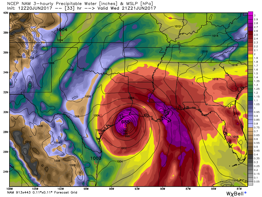
As a result, I’m starting to think the Houston region sees 2 to 4 inches of rain, beginning Wednesday around noon, or later during the afternoon hours, and lasting through Thursday. Moreover, the European model suggests some areas of Houston could see quite a bit more rain than that. I’m not overly confident in that forecast yet, but it is something to watch for in regard to potential flooding. (And we will).
Other effects
If Cindy is going to come ashore near the Galveston area, which at this time seems like a reasonable bet, we also need to take a closer look potential winds. This morning’s forecast from the National Hurricane Center indicated a 34 percent chance of seeing tropical storm-force sustained winds in Galveston this week, but I think that may be a little low. Indeed, if Cindy becomes better organized as it nears the coast, sustained winds may reach 40- or 50-mph where it makes landfall. We’ll have to watch this possibility in Galveston and inland areas nearby, along with the potential for storm tides a few feet higher than normal.
Posted at 2:45pm CT on Tuesday by Eric
Some have commented that Cindy is losing steam and dying off in dry air since it’s stalled. Do you see it still pulling together?
I think what every person reading this post wants to know Eric is – should Katy evacuate?
No, just the people as far away as Champions…. Katy should be able to handle the 15-20 MPH winds as long as you don’t live in a trailer.
BTW, it looked like 13 was starting the hype already at 5 PM. Really? Communicating with a meteorologist via social media to answer questions about the effects of a minimal tropical storm? Sheesh…
Maybe just take the day off just in case.
Yes, Mayor Turner should tell everyone in Katy to take the day off.
This post made my heart happy. It’s been too long since I’ve seen this joke 🙂
Thank you Eric. We rely on your info to determine if our day camp is closed on Thursday.
The biggest shortcomings of the NWS and NHC advisories is that they fail to convey the level of uncertainty of the forecasts. There have been warnings for Louisiana and points east, but not much for the giant Houston metro area despite a reasonable possibility of bad conditions here tomorrow night and Thursday morning. This is why your site is valuable Eric.
Dear Tanstaafl,
In Beaumont where I am, all our weather over the next 48 hours, maybe more, will be under the influence of slowly approaching TS Cindy, and it’s already beginning!
1. The outer bands TS Cindy have already begun to infiltrate the area this afternoon.
2. Northeasterly winds associated with Cindy have already begun to increase this afternoon and will continue to do so during the overnight hours tonight.
3. But don’t worry. I’ll forward what you’ve just said to my supervisor.
You are absolutely right!!!
Thank you for a nice summary of what is happening regarding Cindy. Since storms normally follow the lowest pressure, will the coolish front that is sitting just to the north and west of us keep Cindy from heading our way? In other words will we have the path of lowest pressure for Cindy to follow?
Probably not.
I would think that any power outages in your area would be more of an isolated nature as opposed to the widespread outages of the Ike aftermath, Paul. Isn’t that about right, Eric?
The weather service we use at work has been saying Galveston landfall at about 6 AM Thursday since their early morning forecast, so it looks like the models and forecasts are starting to converge to a narrow range.
Our weather service finally agreed with the NWS forecast around 9 AM this morning. So why are we paying them money for the same answer given later than what we could have gotten earlier for free?
A fair question.
When do you expect Cindy to start moving again?
Some time tonight.
It is not.
Seriously?
Paul, don’t listen to the news media around here. Stick with official statements from government agencies.
After the rather dry May/ June, rain is definitely welcome. Hopefully the winds do not cause much damage.
I’m not following you. I was actually in town that day and can’t remember anything happening.
Eric, I share your concern, but I think you’re a little off. Here’s why:
1. Yes, the track has shifted slightly west and most model guidance has narrowed today with a landfall along the coast between Galveston Bay and Cameron LA. Now, once Cindy completes the current looping motion, she’ll begin to move toward the NW and approach the NW US Gulf coast late on Wednesday. Based on the current forecast track from NHC, I would say Cindy will be approaching the coast late Wednesday and likely making landfall along the SE TX coast NEAR or just EAST of Galveston Bay early Thursday morning and then move NNW and N across deep east TX on Thursday.
2. While the pressure is fairly low for a tropical cyclone, the ill-defined nature of the circulation and broad-nature continues to result in a spread-out wind field. There is very little evidence that upper level wind shear and dry air that has and continues to plague the system will abate much before landfall, although there may be a small window near the coast where the upper level conditions MAY improve, but by that time the circulation will be interacting with the land areas along the coast.
3. The NAM 12 is being NAMish.
Your thoughts?
Thank you so much for this site! This is my go-to place for weather; especially when I feel the local broadcasters sometimes exaggerate.
Man, really miss Eric over at the Chronicle! At least I found him. Thanks for the info friend. Bookmarked.
Thanks for finding me!