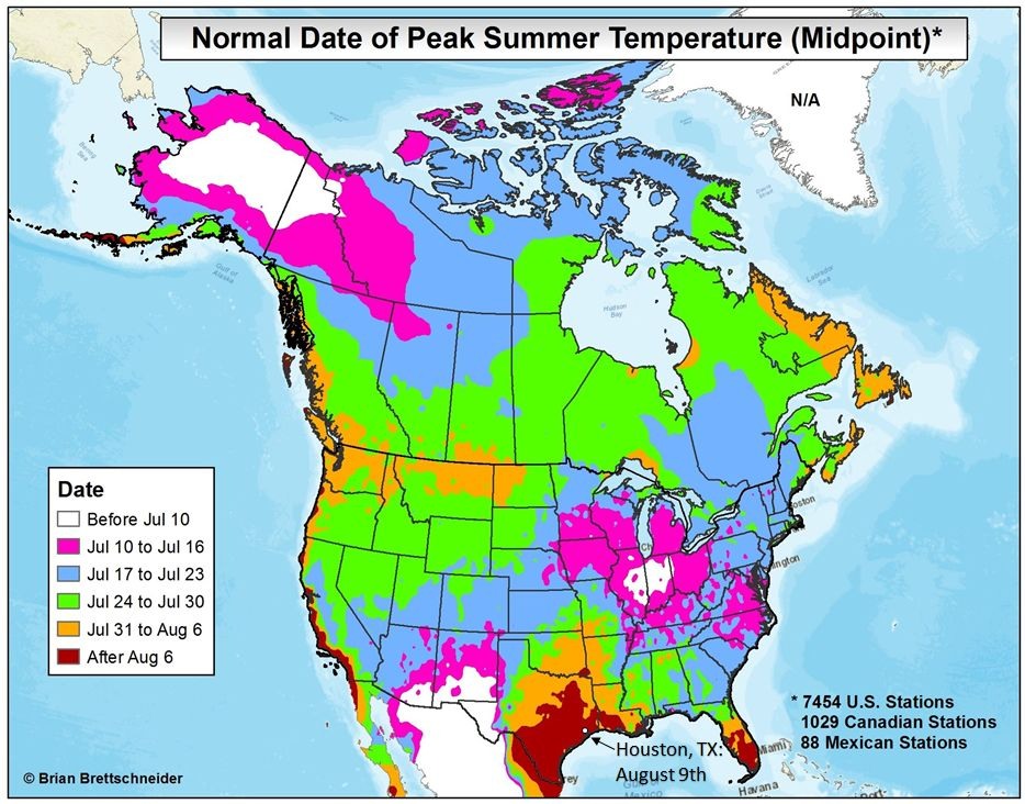
We’ve previously discussed why summer peaks so late along the Texas coast, a phenomenon known as seasonal lag. But now we’re finally here. For Houston’s official weather station, Bush Intercontinental Airport, today is climatologically the warmest day of the year. For Hobby Airport, it’s August 10. For College Station it’s August 11, and for Galveston its August 13.
Peak summer is here, and that means it can finally go. Unfortunately, it’s going to go slowly. (Thanks to Brian Brettschneider for the data).
Today through Saturday
Houston hit 100 degrees on Monday, marking the fourth time this year we’ve hit the century mark. Unfortunately this pattern of very hot days with highs in the upper 90s to near 100 degrees is not going to change this week. We’re going to see hot weather, partly to mostly sunny days, with some scattered showers mainly during the afternoon hours. Summer in Houston is to be survived.
Accordingly, a heat advisory is in effect for today, and will likely continue so through Saturday.
Sunday and beyond
Meanwhile to our east and northwest there will be interesting weather later this week. A low pressure system will travel along the northern Gulf of Mexico coast, drenching the Florida Panhandle, coastal Alabama, and much of Mississippi and Louisiana between now and Monday. In addition a cool front will move into west and northern Texas, bringing rains to those areas. This can be seen in a rainfall accumulation map for now through Sunday.
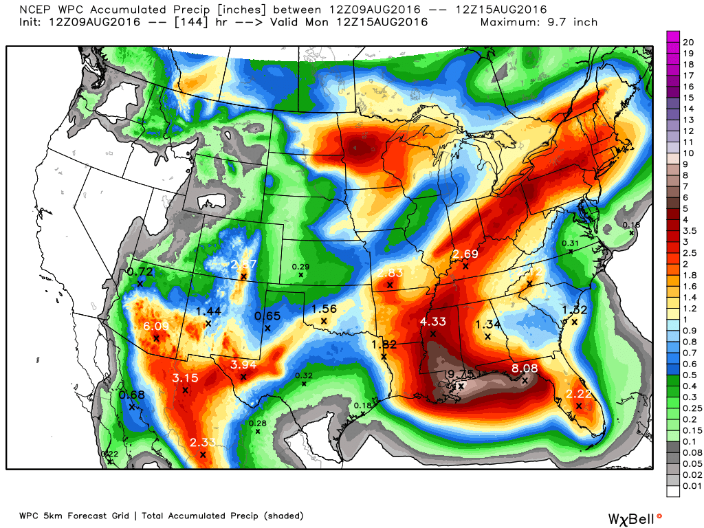
What does all this mean for Houston? The answer is not yet clear. But it’s possible that by Sunday or Monday we’ll see some moisture from the low pressure system to our east, and instability from the front to our northwest, the tangential effects of which could combine to bring some better rain chances and cooler weather for next week. The forecast remains far from certain, but I do think we may see a bit of a reprieve from our peak summer-like conditions.
In what year were heat advisories first used in weather forecasting? What is the record number of consecutive days that a heat advisory was issued for Houston? I remember 1980 being exceptionally hot.
I don’t know when heat advisories were first issued, but they are not uncommon during summer months in Houston.
As for 1980, it was the benchmark for heat in Houston — before the summer of 2011.
Today I learned that there’s an excessive heat warning which is worse than a heat advisory.
2011 was the Summer from Hell. If I recall correctly, every single day in August (save one) hit 100 degrees or higher, with hardly a drop of rain.
Every day but one. Pure hell is right.
What do the tropics look like with regard to our weather for the coming week, Eric?
Tropics are quiet, it would appear, aside from the blob that’s going to bring a lot of rain to the norther Gulf coast.
“…it’s all downhill from here”…ooook Eric, I’m gonna hold you to it! And, Holy Cow, I sure don’t remember August in 2011, all but one day reaching 100 or higher…WOW! Kinda makes me get ok with this summer’s heat…sorta…but not really!
August, 2011, was a horrible, horrible month.
I want to get past August. Really.
As I posted on Facebook: “August in Houston: When you can turn on the cold water in the kitchen, and get 3 seconds of cool water, then 30 seconds of water hot enough to make coffee, and finally water cool enough to pour into the coffeemaker.”
Dear Eric,
Is any flash flooding or lightning damage likely due to these storms? Hey, I know we need the rain, but there is the old saying—“Be careful what you wish for.”