When tropical systems get going, the internet can be a noisy place. So Eric and I thought it would be a good idea to give everyone a user’s guide to the next tropical system that you’ll be hearing about.
What is it?
Invest 97L is the current classification of the tropical wave on the way to the Caribbean. Satellite imagery from late this afternoon shows Invest 97L approaching the Leeward and Windward Islands.
“Invests” are the classification given by the National Hurricane Center to tropical disturbances that may develop into organized depressions, storms, or future hurricanes. There are numerous “invests” each hurricane season, and the cycle runs from 90 to 99 and then repeats. Basically, it’s a nice way to keep disturbances orderly in their computer systems for tracking and monitoring purposes.
The National Hurricane Center sent out reconnaissance aircraft today and were unable to find a center of circulation at the surface, so they’ve held off on classifying this as a tropical depression or tropical storm (which will be named Matthew, assuming it gets there).
Will this threaten Houston?
Now that you know what it is we’re talking about, let’s get this out of the way right now. Meteorologists almost never speak in absolutes, and with tropical systems we never really should. Here’s the deal. Weather models offer little help right now.
EPS still all over the map when it comes to possible spots for future #Matthew. Pictured is 8 days from now. pic.twitter.com/mIP9zCeWcp
— Eric Fisher (@ericfisher) September 27, 2016
The European ensemble referenced in the above tweet is basically the ECMWF model run over 50 times with different tweaks to each ensemble member. You can see that it has this thing all over the map. “Invests” are inherently unpredictable. We know something is likely to develop, but where it goes and how strong it is is a very debatable issue. And this sort of model disagreement is about as bad as it gets.
It’s also worth noting the time of year we’re in. The calendar is about to flip from September to October. Historically, hurricanes are unlikely to impact the Texas coast this late in the season.The last storm to impact Houston in October was Hurricane Jerry in 1989. So history is to some extent on our side here. Eight storms in 150 years? Those odds aren’t bad.
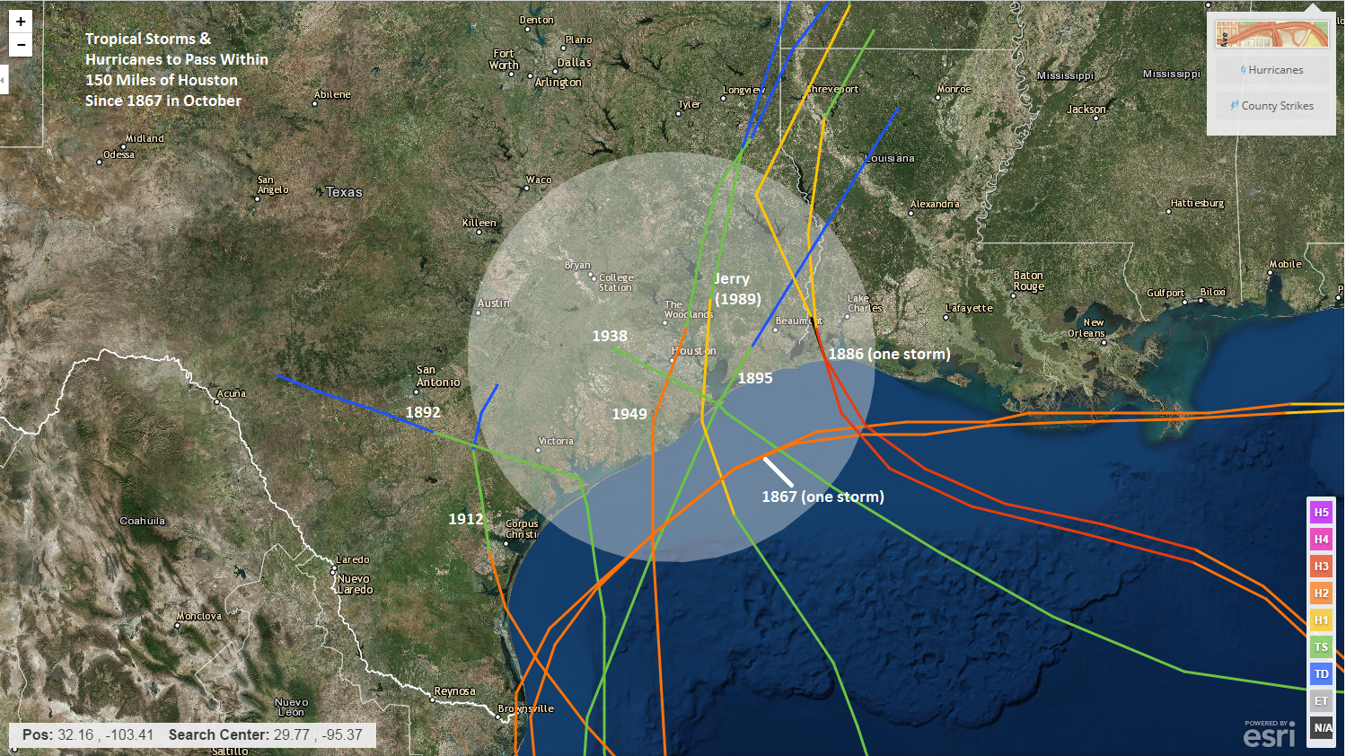
It’s also worth noting that of the 66 storms in any month to track where 97L is likely to become Matthew in the Caribbean, only one ever impacted Houston directly (two impacted the Golden Triangle directly).
So is this going to hit Houston? Probably not, but given the extreme model uncertainty, it would be wise for us to continue watching.
So where is it going?
I absolutely love this image from Dr. Brian Tang at the State University of New York in Albany. This shows the European ensemble model and basically quantifies what percentage of the 51 members shown in the tweet above track over a given area. Red indicates strong agreement among the ensemble members tracking over that area. Blue shades indicate a lower percentage of members tracking over that area.
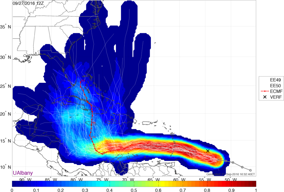
Over the next 3-5 days, this system will track just north of the South American coast. Once it gets south of about Jamaica though, all bets are off. It appears there are two clusters, with one pressing it toward the western tip of Cuba and another taking it straight north toward the Bahamas or Florida.
So over the next 4-5 days, we have high confidence that this system will continue westward. Beyond day 5, we have little to no idea exactly what (should be) Matthew will do. So don’t expect much new forecast clarity until perhaps this weekend.
What should you be doing now?
Nothing really. It never hurts to make sure your hurricane kits are up to date though. Like I said, I don’t really think this will become a threat to Texas, given the time of year and the odd location it’s coming from. But, given the large chasm between weather models and large degree of uncertainty right now, it’s wise to continue monitoring. We’ll naturally be keeping you up to date on this system’s development and evolution as it moves across the Caribbean. Should it become a real threat, you’ll know, but at this point, it’s just something to watch out of the corner of your eye.
When might this make landfall if it hits Florida? With some HISD holidays coming up, there are many families going to Walt Disney World!
If it were to impact Florida, it would likely be mid to late next week. Wed-Sat would be the window to watch right now.
Good evening. We are supposed to be leaving for Turks & Caicos on Sunday for a week. Thoughts on impact there.
You’ll want to continue to monitor the forecast closely. If it were to impact T&C, it would be early next week (Mon-Wed). It’s going to be a very close call there, but hopefully misses to the west. Wish I could give you something more definite, but unfortunately we just can’t yet.
I remember Jerry. The Chronicle dubbed it a “Tropical Dud”.
I was living in League City at the time. The eye passed right over my house, knocking over one section of fence. The front eye wall rain lasted maybe five minutes, three or so of less intense rain on the other side. Maybe an inch and a half of rain.
It went up 146 and did some damage in Baytown around the (then) tunnel.
Hobby got no rain, the West side of town no clouds. That’s how small a hurricane it was. The anti-Ike.
I know that often one storm system follows another. Is that shaping up this fall? Particularly concerned about mid-October.
Sid
Heading to Tampa from Boston weds next week. Thurs across state to Fort Lauderdale. Fri early morning to Barbados. I am watching closely
What’s up with those two “one storm” lines in the hurricanes that hit Texas in October graph from the 1800’s?