I wanted to take a few minutes this morning to explain what happened with our forecasts for potentially very heavy rain on Friday night and Saturday, why we made the decisions we did, and then talk about what’s ahead for Houston in what will remain a wet pattern for a few more days.
FRIDAY’S MISS
For a couple of days Matt and I have been talking about the potential for very heavy rain in Houston this weekend, especially Friday night and Saturday morning. We weren’t alone, of course. The National Weather Service issued a flash flood watch. A lot of people were concerned. But I can only speak for our forecasts.
By early Friday afternoon we were pretty concerned, and wrote so here. Several high resolution forecast models were showing the potential for very heavy rains and severe storms later that evening and during the overnight hours.
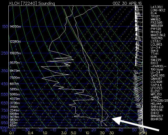
These model forecasts were predicated on a capping inversion, an area of warmer air above the surface that prevents surface moisture from rising, breaking down. This didn’t seem like an unreasonable expectation, but unfortunately we don’t have good, timely data on the “cap.” The best information we have comes from “soundings,” essentially weather balloons sent into the upper atmosphere twice a day. But there are no Houston soundings. For Houston, the closest sounding locations are in Lake Charles, La. and Corpus Christi. A 7pm CT sounding from Lake Charles showed there was a stronger cap in place than the models were predicting.
Even before this sounding became available, however, it was clear some of the most bullish models had not initialized well, and rain showers were not likely to develop over Houston on Friday evening or night. We acknowledged this in a post at 7:30pm CT, telling people the threat of severe weather and flooding Friday night in Houston had passed.
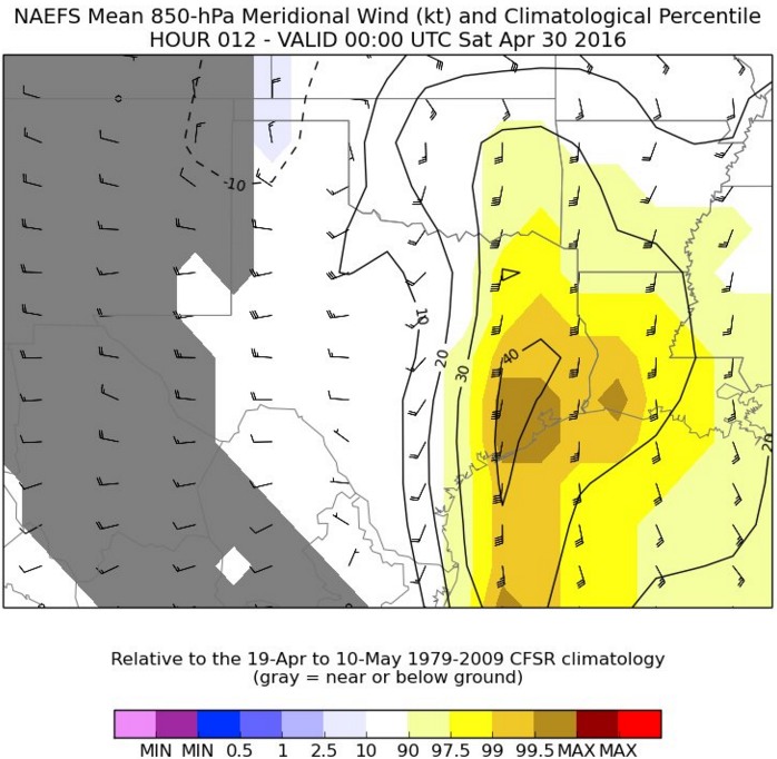
Meanwhile to the north of the Houston metro area, where the capping inversion wasn’t so strong, the moisture and upper level low pressure system were bringing multiple inches of rain. And its not hard to understand why. The following graphic shows the northerly flow off the Gulf of Mexico on Friday evening. Essentially this means the strength of winds about 5,000 feet above the surface of the Earth were in the 99th percentile in terms of transporting moisture inland.
So the ingredients were there for major rains over Houston, but an unexpectedly strong cap kept them at bay. This is not to excuse ourselves. The forecasts made on this site from Thursday through Friday afternoon clearly oversold heavy rain and flooding. I wish I could go back and change them, but knowing what we knew at those times, I don’t regret those forecasts. They were just wrong. It happens in meteorology. And there’s no shame in having an honest conversation with readers about what went wrong.
SATURDAY’S STORMS
Once it became clear the capping inversion was holding, we were able to better forecast the potential for storms this morning over Houston, especially the northern half of the metro area. We were fortunate this system was progressive, in that it moved quickly through. One area in The Woodlands, Alden Bridge, reported 0.96 inches of rain in just 10 minutes during the peak this morning. If those kinds of rains had stalled out over Houston we very quickly could have seen a dangerous flooding situation.
AHEAD
As of 9:45am CT the last line of these storms is moving quickly off to the east, and I think we’re pretty much done with rain for today. There may be a few pop-up showers or thunderstorms this afternoon. For Sunday I think we’ll continue to see the potential for some scattered showers and thunderstorms but nothing too organized. We are not looking at a total washout, in any case.
I do have some concerns about Monday, when the atmosphere may have a chance to recharge and we see some more organized storm activity, perhaps during the morning hours. We’ll have to at least consider the possibility of some localized flooding. Matt will have an update on Sunday morning to assess the potential for rain later that day and on Monday and Tuesday.
Good job, thanks for the info and we have had enough rain!
Eric – what is the explanation for the NWS not taking soundings nearer to the Houston area?
Funding. They try to distribute the sounding locations around the country. Chicago is also in poorly covered area.
http://www.ua.nws.noaa.gov/nws_upper.htm
Distribution makes sense given limited resources, but 2 of the 4 largest population centers in the country have poor coverage? That seems less than prudent….
No one should be complaining about missing severe storms! It seems clear to me that God saw fit to spare us by leaving that Cap in place. Thanks for being a clear voice of reason for us Eric.
I couldn’t agree more with Ellen!
Thank you for keeping us informed.
By that logic, God really let us have it on the 15th. Wonder what we did to upset him so.
Yeah, the “God spared us” argument leaves all those other people (like the grandmother and her five grandbabies who died overnight from flooding) screwed. What did they do wrong that God abandoned them? That’s the reasoning if you think that God has anything to do with our weather.
Very much appreciate the candid update. Rather you err this way than the other way.
Thanks, Eric! I really did wonder when we had .25 inches this morning/total in the last two days. Is this another case where the city of Houston really needs a weather balloon redeployed? What’s kept that from happening?
Yes, local soundings would have helped.
I have the same question as Heather. It would seem that, given the distance between Lake Charles and Corpus and the presence of a rather large metro area within that arc, this would be a good resource to have. Is it a question of budget? Politics?
Yeah, it’s primarily budget and a desire to have them relatively equally spaced across the country.
What is the cost of a balloon? Does it have to be a government-funded deployment or is it something that could be privately funded, i.e. by a local O & G business or some such with a vested interest in the city?
About $150 per balloon, launch cost and analysis may add some to that. Let’s say two times a day, $400, per day.
So perhaps about $150,000 per year for a site in Houston
Well this explains why our forecasts are wrong so often. Not talking about yours, this is my first time on this blog.
Thanks for stopping by!
No shame in it. Great work as always. Thanks for your service.
Keep up the great work, Eric and Matt! Y’all are still far and away THE go to place for Houston weather!
Thanks for the great explanation. I might actually start to understand meteorology if I keep reading Space City Weather.
You might even understand it better than those guys who predict the weather on TV.
Eric, Matt. We know Meteorology is far from exact science. No hype while your explanations were bringing us clear information to understand the phenomena. Thanks a lot for the great work, I will keep reading you daily as I’ve done since SciGuy blog.
Thank you for the updates, and for being so upfront with us. The way you discuss the ups and downs of meteorology is awesome; it makes me feel like we’re all friends hanging out with you at Starbucks and you’re giving us the latest prognostications about our wild and crazy weather! Reminds me of FDR and his amazing Fireside Chats. Keep up the good work, Eric!
Your candor is appreciated.
Thank you for posting why you were wrong. Lot’s of plans were cancelled based on the reports, and we were disappointed. I appreciate the review, and we certainly didn’t need the rain.
Any chance we’ll be able to have an app for you guys on our phones soon? You are my voice of reason and calm when all else says doom and gloom.
Not considering apps at this time. We may try to set up some kind of notification service.
Thanks for great explanation. Really enjoy your weather insights.
Eric,
No apologies or shame needed. Your candid, science-based explanations are superb and one of the few sources of such local information. I look forward to each of your posts and understand that caution is always better when the potential for severe weather is present. Keep up the good work!
Ken
Still my go-to for weather. I’m glad we didn’t get the heavy rains.
Thank you for the info…last night in Houston could have been this:
http://www.cnn.com/2016/04/30/us/severe-weather-texas-louisiana-south/index.html
I love your honesty in all things. You know, I prayed quite earnestly for the crazy stuff to stay aloft so that may have thrown things off if my prayers were answered. You teach us a lot about weather, keep us all posted on what’s happening and yes, I think we all love you 🙂
Great info! Thanks!
Sci Guy’s forecast = best estimate based on available data
TV Newsguy’s forecast = worst possible scenario even though it’s not the most likely scenario
Thanks for keeping it real, Eric! At the end of the day, I’m just glad we dodged another bullet on the west side of town!
They’re going to try it again on Monday. You watch.
But we might not dodge a bullet on Sunday and Monday if you believe Accuweather’s Henry Margusity.
http://www.accuweather.com
(see blogs)
So, what would an independent balloon sampling program for the Houston area cost roughly? Maybe it could be funded by local businesses which would benefit from more accuracy such as ports and shipping, insurers, TV stations and toll road guys county and city, etc. Maybe UH could run it?
Is there a store where I can buy one of these balloons?, hm?
I don’t watch the mainstream media, but it’s hard to imagine them owning their missed calls and explaining why. Your approach is refreshing and gratifyingly scientific. If you were hitting 100% of your calls on the weather, these comment threads would be either speculating on your pact with the dark forces or begging for lottery numbers. Keep up the fine work….
Thanks, Eric.
Interesting that this bust of forecast comes within a few days of a much larger forecast bust to the north of us, chronicled by the Washington Post. I’m sure many saw it, but if you haven’t, it’s worth a look.
https://www.washingtonpost.com/news/capital-weather-gang/wp/2016/04/27/tuesdays-severe-weather-bust-is-a-communication-wake-up-call/
Great site — we are good friends with the Capital Weather Gang.
“I do have some concerns about Monday, when the atmosphere may have a chance to recharge and we see some more organized storm activity, perhaps during the morning hours. We’ll have to at least consider the possibility of some localized flooding.”
You think Monday May 1 will be a washout, like Monday April 18 was, Eric?
No.
Surely the soils in the Houston metro have absorbed more of the rainwater since Wednesday, Eric. Will that help the tree situation any if so?
Hard to say for sure. Definitely so for southern half of Houston, but the northern half got pretty wet on Saturday morning.
I think what SkyGuy’s asking you, Eric, is what the present condition of the soil is in the Houston metro proper. I’d like to point out, myself, that we haven’t had any heavy rain since Wednesday.
P.S. I hope we don’t get any Monday.
Hi, Eric.
Interesting. Tx Tech forecast model says (if it verifies) areas to the E/SE of the Houston metro will see the heaviest storms. Metro gets a broken line of showers.
http://www.atmo.ttu.edu/bancell/real_time_WRF/ttuwrfhome.php?dmn=2km&prm=sfc_dbz&run=0
See hours 40-59 and tell me if you agree or disagree. Is the line broken or am I just imagining things?
Don’t read too much into any single run of a single mesoscale model, but it is certainly plausible that the heaviest storms tonight and Monday will be east of Houston.
I couldn’t help but notice that most of the global models, except the NAM, seem to be backing off of any kind of severe event for the Houston region. If anything, they say the rain will be more of a scattered nature. Can anyone tell me why?
NAM isn’t a global model. Also, in this case it’s generally better to rely on the mesoscale models for trying to predict local conditions rather than the globals.