We’re continuing to watch the development of a tropical disturbance in the Caribbean Sea, near the Yucatan Peninsula, that is moving toward the Gulf of Mexico. This system could play a major role in the Houston region’s weather later this week—or very little. But it’s something I think is definitely worth paying attention to.
Will it develop?
At present the system is a broad area of low pressure, but a lot of forecast models are bullish on its development into something akin to a relatively weak tropical storm over the next few days. The National Hurricane Center believes this, too, giving it a 90 percent chance of development into a tropical depression or storm during the next five days. (A hurricane hunter may investigate the storm later today). Although we can’t rule it out, this tropical system appears unlikely to reach hurricane strength, and therefore the primary threat will be a lot of rainfall.
Where is it going?
This is the key question, and one that remains difficult to answer. We can be reasonably confident the tropical system will slowly move across the Yucatan Peninsula today and Monday, and thne find itself in the southern Gulf of Mexico. But this is the easy part of the forecast.

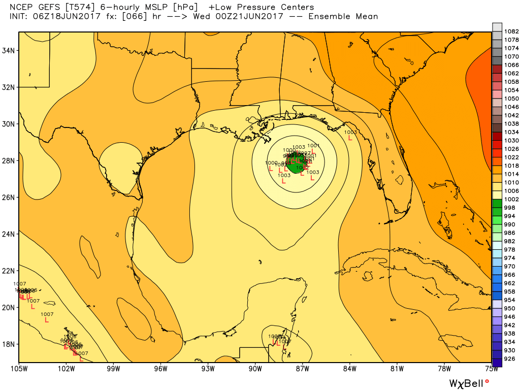
From this point, the models diverge quite a bit (and have consistently done so during the last 48 hours). The GFS continues to develop the storm fairly quickly, and bring a tropical storm north, across the central Gulf of Mexico and into the northern Gulf of Mexico coast, between Louisiana and the Florida panhandle by early Wednesday. If we look at the GFS ensemble model locations for the center of low pressure on Tuesday night, they are clustered remarkably close to one another, suggesting the model has high confidence in the solution.
At the same time, the European forecast model is equally confident in slower movement of the tropical disturbance, and a weaker overall system. This scenario brings the storm toward northern Mexico or the Texas coast by Wednesday or Thursday with a fair amount of moisture. Here’s a look at that potential outcome:
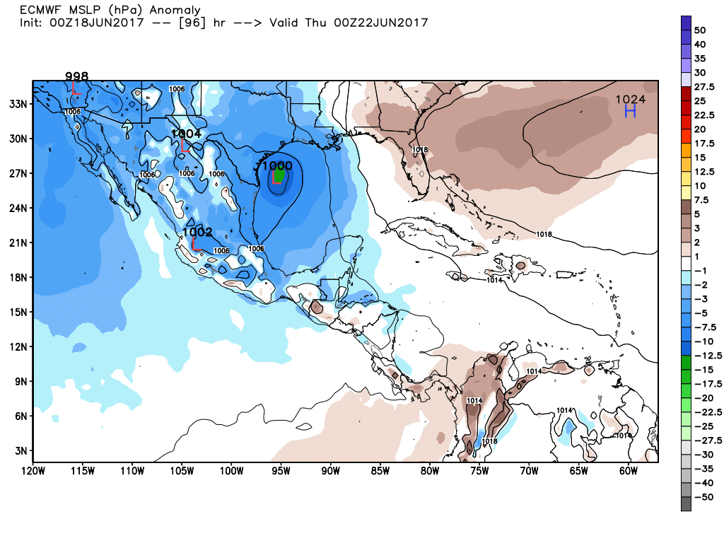
As a general rule, the European forecast model does a better job than the GFS, and because the system remains disorganized, I think that increases the likelihood of a more westerly track across the Gulf of Mexico, toward Mexico or Texas, during the coming week. But we just can’t pick a winner yet, and probably cannot until the system moves into the Gulf of Mexico and develops a more organized center of circulation.
Implications
What we can say is that if the system moves north as the GFS model suggests, Houston will see minimal effects. That is because most of the “weather,” in this case the winds, rains and higher tides, are to the east of the center of this storm. Therefore even a landfall in Louisiana would mean little for Texas.
Conversely, if the system moves toward the central or southern Texas coast, the Houston area would be on the side of the storm with all the “weather,” which could mean a few inches of rain, or more. That remains our primary concern right now.
Posted at 8am CT on Sunday by Eric
Good stuff, Eric. Out of curiosity, why is the European forecast model typically more reliable than GFS?
It typically rates significantly higher on skill scores and forecast accuracy. Generally, it does a better job of taking real time meteorological data and incorporating it into future forecasts.
GFS is an older model, isn’t it?
No, it’s regularly updated. It is the premiere global model operated by NOAA.
Eric, I think you should answer Paul. I’m worried that we may see massive flooding similar to what happened on Tax Day 2016 and Memorial Day 2015! To say nothing of the big winds that’ll probably blow through the area on Wednesday!
I don’t personally see Tax Day 2016 flooding because that particular system moved counter-clockwise. 93L will move clockwise. And there shouldn’t be any blocking high to interfere with its movement.
Paul, this won’t be a major wind event because, fortunately for us, it’s not well organized, but you need to be cautious, because the time window on effects regarding rain and flooding could be in a 48-72 hour range. The models still have a complex forecast to work out as regards direction, strength and timing. It’s just that you need to be aware of the possibility of a significant rain event if the system heads towards Texas. Is my assessment correct, Eric?
Eric- thank you for always being cautious with your forecasting. I watched morning news this morning and The Weather Channel and both gave totally opposite forecast. The local news was using the GFS and TWC was basing their forecast off the European. But comma unlike David Paul and you, neither was paying attention to the fact that 90% of the weather was on the North and East sides of it.
Thank you, Rob.
First, I’d like to thank you for your time in providing the updates and having trying to set realistic expectations.
With a late cold front coming through the next couple of days which will barely reach Houston, would this affect the direction of the tropical disturbance, possibly nudging it more eastward? In addition, would there be enough dry air from the cold front feed into the disturbance to weaken it?
Thanks, keep up the excellent work
I don’t think the front will have much of a steering effect.
Per usual: Be Prepared, but watch the weather. There are too many variables to be sure at this time.
This is the one place that gives it straight. Thanks.
I believe we will see the most significant damage in the area since Hurricane Ike, with millions of homes without power!
Doubtful.
Well, that depends, Eric. If we see any unexpected strengthening…..
I hope it hits Houston.
Believe it or not, Faisal, floods lead to water shortages because so much is lost as runoff. We’re better off on the west side of this storm, trust me.
Thanks, Eric and Matt, for being the one reliable place to turn for weather!
Hopefully, the media won’t go bonkers and tell people to head for the hills. It may sell advertising, but kills their credibility for when the next Cat 4+ heads our way for real. If I were mayor Turner, I’d be having a discussion with the station managers about this.