Good morning. Yesterday was the 16th day this month that we officially hit 95° or hotter in Houston. The last time we did that was 2013. At least this isn’t a repeat of 2011, when we did 95+ on 26 occasions. We will continue to flirt with 95 degrees for the final three days of June. More on that in a second. Below today’s forecast, we’ve got some analysis on the National Weather Service post-Harvey service assessment that was released last week. I farmed out some interesting tidbits for you that may be of interest. First, the forecast.
Today & Friday
More hot weather is in store for us over the next couple days. We had a handful of showers in the region yesterday, and we’ll probably have a handful more today. However, atmospheric moisture looks a bit more robust today than it did yesterday, so that should yield a slightly larger handful of showers than Wednesday. That said, we’re talking like 20 percent chances at best here. Basically, if you see a cooling shower today or tomorrow, consider yourself fortunate.
Temperatures will peak around the middle 90s once again both Thursday and Friday.
Weekend
Shower chances continue to look like they’ll dwindle to near zero this weekend. With that, expect more hot weather. Officially, high temperatures should reach the mid-90s both Saturday and Sunday. Take it easy outdoors, as it will continue to be quite humid and uncomfortable.
As noted yesterday, we will also be dealing with Saharan dust. Skies will be hazy or gray looking at times, despite sunshine. And again, if you have any respiratory ailments or bad allergies, you may want to take it a little extra easy this weekend, as air quality could be a little worse than usual.
Just to clarify, as we’ve gotten a handful of interesting questions, this isn’t a dust storm or big, unique event for us. This happens at least a few times a summer usually. The vast majority of us will notice more haze than usual and the color difference to the sky. Maybe, if we’re lucky, the sunsets and sunrises will be more vibrant, though I’m happy to put a Texas sunrise or sunset up against anyone’s on a normal day. Sometimes, too much dust can have the opposite effect and dull the sunsets or sunrises a bit.
The only real “impact,” per se, is the slight increase in particulate matter, which is why if you have bad allergies or other respiratory ailments, we encourage you to take it easy. It’s certainly meteorologically interesting and a nice reminder of how fascinating this marble is that we inhabit to realize that you’re seeing dust in the sky in Texas that’s come all the way from Africa.
Next week
We do still look to be on track for a change next week, though the details are very uncertain. We’ve got high confidence in Monday still looking a lot like the weekend, with some haze and plenty of heat and humidity. By Tuesday, a disturbance aloft will be approaching western Louisiana, perhaps generating slightly better storm chances east of Houston toward Beaumont or Lake Charles. After about Tuesday afternoon, forecast confidence trends downward. Wednesday will probably see our storm chances peak in the Houston area and just east, but depending on the speed and trajectory of next week’s disturbance, that could easily get pushed back to Thursday.
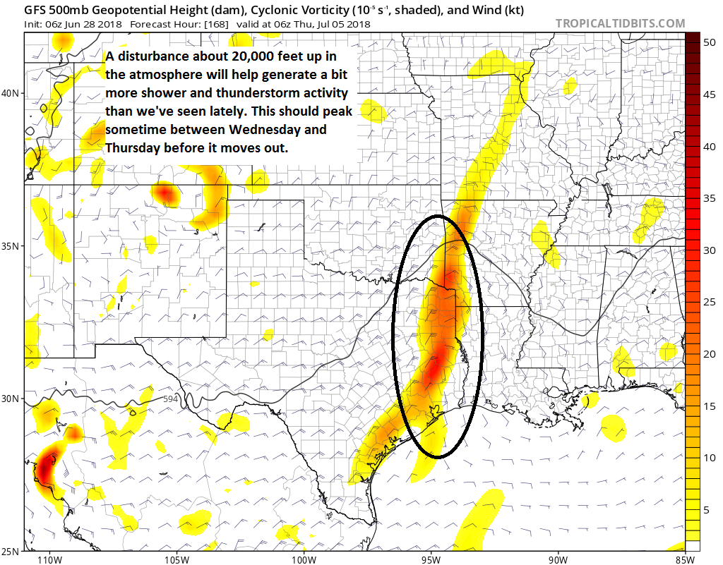
So before you go cancelling any plans, just know that as of right now we don’t expect a washout on the Fourth of July yet, just a better than average chance of storms. That said, yes, if you have outdoor plans you want to stay tuned to the forecast, as this could shift one way or another pretty easily. More on this tomorrow.

Hurricane Harvey assessment
The National Weather Service released their Hurricane Harvey Service Assessment last Wednesday. After major weather events, the NWS usually goes back and reviews their performance, conducts interviews, and produces recommendations based on the findings. The last NWS assessment was Hurricane Matthew in 2016 after it hit the Southeast. The assessments are usually very informative reads and helpful, though they are done by only folks within the government, so there have been arguments made in the past that this prevents a complete picture from being painted. At any rate, this report, at least on the surface, seems mostly non-controversial. I think there has been mostly universal praise of how NWS handled Harvey. Certainly we would agree that the NWS office in League City that serves the Houston area did an exemplary job during Harvey’s fury here. But there’s always room to improve, hence the assessments.
It’s a 78 page report, so if you’re looking for some light reading heading into the weekend, you can certainly pore over it, but in case you’ve already got plans, I pulled out a handful of notable highlights.
- In one of our hurricane season preview articles, I got insights from a couple NWS meteorologists that were personally and directly impacted by the storm. Turns out that did impact employee morale to some extent and the recommendation was to clarify and improve those issues before events next time.
- They found that the NWS had no products that could effectively communicate the impact 60″ of rainfall would have on communities. They recommended that historic flood inundation maps be made available to folks on their websites.
- Decision-makers need probabilistic forecast information to help make plans well in advance of a storm. Probabilistic forecast information basically gives goalposts to emergency managers and others on how bad or not so bad things could be. That would help inform their decision-making process, specifically toward evacuations. This finding was also re-emphasized for regular people in terms of how they were interpreting rainfall forecasts. There was some confusion based on how quickly things changed throughout. Had the risk of that change been adequately communicated beforehand, it could have limited confusion.
- There were discrepancies in what rainfall forecasts were being used, which led to some degree of confusion among the different agencies using those forecasts. The Weather Prediction Center (which generally does an outstanding job with rainfall forecasting) was lauded in this assessment, and the sense I have is that this report implies they should be given some codified authority on rainfall forecasts.
- There were a number of software and technical glitches that occasionally impeded NWS folks from having an optimal setup leading up to, through, and after Harvey. Recommendations are made to fix these problems, a few of which were also noted in the Hurricane Matthew service assessment.
- There was a lack of diversity among NWS partners in a region that is extremely diverse. The authors recommend a push toward improving and expanding relationships with underserved populations and organizations. I attended a talk at a conference earlier this year given by an employee of the NWS office in Milwaukee that explained how they were attempting to reach people experiencing homelessness during significant weather. There are a number of populations that are underserved here in Texas, including the many non-native English speakers that live here. Sometimes what may seem clear to some people in English is not at all clear to those folks. The assessment team did find that language was a barrier to effective response and emphasized continuing to improve that outreach.
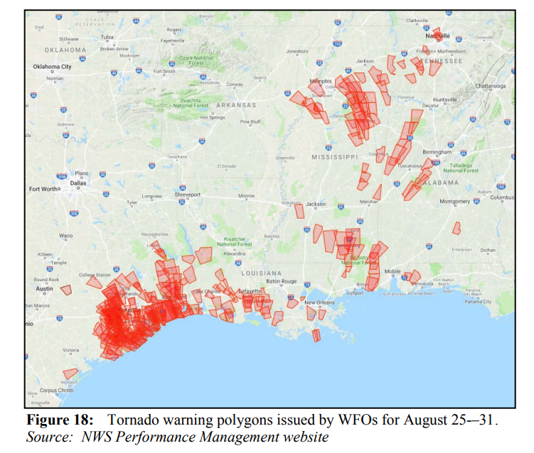
- What I found most interesting: People interviewed by the assessment team generally responded favorably to the quantity and frequency of tornado warnings, which counters a lot of what we’ve believed and heard. People getting wireless emergency alerts said they “appreciated the heads up,” even if they didn’t act for every warning. This is an area that needs more research in my opinion.
Again, the report is lengthy and a bit in the weeds, but it’s a worthy read if you have the patience and time.
Harvey Assessment – Good summary. I have to particularly agree with your tornado comment. While, in general, we appreciated the notices they were not location specific enough. I believe some work has been done to refine this. Notifications that were county wide alarmed more than informed.
Totally agree. Brazoria County is very large and we could have beautiful weather in Pearland and a tornado in Lake Jackson. Need better than county level warnings especially for us neophyte east coast transplants. Love you website and no hype forecasts.
See my reply to Lee.
The problem with the alerts is the same problem with operating system error messages or bad SSL warnings on web sites—99% of the time, they’re nuisance warnings, and so people ignore them. Personally, the first thing I do when I get a new cell phone is disable all government alerts because they’re used so often and so poorly that they’ve become useless.
I recognize that this is very bad, as that 1% of the time that an alert ISN’T useless could save my life, but after being terrified out of sleep by the things or startled when one blares at max volume over my car speakers while driving, leaving them enabled feels crazy.
Your issue with the cell phone alerts may be more related to problems in the cell phone network. Warnings these days are, and for some time have been, targetted to very specific areas. These are the warning polygons in the graphic. However, the method of delivering those with accuracy is somewhat lacking. The cell phone network is most likely using tower triangulation, rather than GPS. I recall reading that there is some work being done to improve the accuracy of wireless alerts. Cell phone apps, as well as Google at least on Android, are going to do better with that due to the use of GPS on your device. Wireless alerts are federally mandated in a law passed sometime during the 2006-2010 timeframe.
NOAA Weather Radio, while still a very good thing, is also able to operate only on a county level; I’ve certainly never seen a receiver with GPS.
I think the NWS and local news outlets did a phenomenal job forecasting and warning the public that a 40” + rainfall event was possible with Harvey. And the warnings were issued 3-4 days in advance so we all had plenty of time to prepare.
Growing up in Houston I have endured two other historic flooding events in Claudette and Allison and no such warning was given. Forecasting is much improved and that had to save lives in Harvey.
So I for one commend the job by the NWS. They did a great job forecasting this event.
Agreed. I remember seeing everyone stocking up on groceries – not because of fear of hurricane winds and loss of power, but because we were told that historic floods would more or less leave us stranded for days. I remember them telling us this would be worse than Allison. They were spot on, and most of us were prepared because of it.
This is one of the best forecast significant events I can recall.
We should be thankful that we didn’t lose power region-wide, or have massive damage done to the cellular communications network. Imagine if for instance Harvey hit more directly the Houston area, then lingered as it did for days dumping feet of rain.
A lot of lives may have been lost because of an inability to both send and receive warnings.
We got lucky Harvey was only a rain event. It was unprecedented, and as such, we should prepare for the next unprecedented event – whether it impacts Houston or elsewhere in the USA.
Interesting and varied findings that are a little more gritty and hopefully more productive than the usual reports with typical findings in the neighborhood of, “More cooperation between authorities is recommended.”
I very much agree that the frequency of the tornado alerts should be looked into a little closer. I appreciate that there really was quite a bit more twister activity than we usually get after landfall, but after about the third day those were driving us all a little batty.
I’ve decided the night Harvey was at his worst that best answer is to get the heck out of Houston and to the mid-South so I don’t experience another hurricane or our annual 100-yr floods again. Continuing to live here is simply to invite more of the same nonsense.
Unfortunately, that will take about three years or so but that’s the plan.
We have a Chinese exchange student who has lived with our family for the past two years & will be returning for her senior year in high school. We live in Katy, and Harvey was eyeopening for her (thankfully we didn’t flood). She is looking at US colleges & one of the things that she has asked us about is the natural disasters that happen in the places she’s considering. There’s no real safe spot on her list–California has wildfires and earthquakes, New York has blizzards (and hurricanes too!), and the South has hurricanes and tornadoes. I can’t say I blame anyone for wanting to get away from the hurricanes though. Hopefully we never have a repeat of Harvey.
There is no place you can go to escape natural disasters. In general, the US is one of the countries best able to withstand them. Our infrastructure, for all its faults, is actually quite good. A large death toll in this country is over 50. In most of the world, that would be unbelievably light.
As a for instance, China has at least nine of the world’s 46 deadliest earthquakes for which we have any kind of record (including a 16th-century earthquake which killed in excess of 800,000 people). Four of these happened in the last century. The top 3 deadliest disasters of all time happened in China, and they have five of the top 10.
We are so accustomed to relatively light death tolls that many people never thought we would see a hurricane kill in excess of 1000 people in this country. Then Katrina happened. Many thought we would never see tornado outbreaks that would kill several hundred people. Then the April 2017 Super Outbreak happened. Many thought a single tornado would never kill over 100 people again. Then Joplin happened. For my part, I was always in the “it’s going to happen” again camp.
In reality, there’s nowhere you can go. The first ever Flash Flood Emergency was issued in Tennesse, and I believe it was for a non-tropical event. You can make a strong case that the worst place to live in this country with regards to tornadoes is not Tornado Alley, but rather in northern Alabama. Indeed, the two largest tornado outbreaks on record (April 1974 and April 2011) happened between the Mississippi River and the Appalachians, with Alabama being especially hard hit in both. Anywhere from the Plains west, you have a heightened risk of wildfires, earthquakes, and volcanoes. The north has blizzards. I think we all know the hazards facing Hawaii. Almost everyone has a risk of severe droughts. Most everyone has a risk of devastating heat waves.
In determining where to live, where to go to school, etc, it should really be about maximizing whatever you determine to be your quality of life. The types of disasters you might face can certainly factor into that. For myself, I would much rather deal with tornadoes and hurricanes than earthquakes. Earthquakes are essentially the only natural disaster that can strike without warning. At best, you might get a few seconds. Tornadoes and hurricanes give lots of warning, ranging from hours to days. The bulk of them also occurs within well-defined times of the year.
I should really turn this into a blog post.
@Jonathan: you don’t mention the New Madrid fault, which is one of the greatest earthquake risks in the US–right through the mid-South–the earthquake there in 1809 or 1814 or whatever actually made the Mississippi River flow backwards.
I have bought a rubber raincoat for hot weather and all of the rain that we’ve been getting.
I felt like for the most part , an assessment of the NWS was looking at the wrong issues…i.e. Houston should have never grown to the size it is , and with more single story residents than many other major metropolitan areas, and as it was all a gigantic ‘swamp’ when the Allen brothers settled around Buffalo Bayou..In the flood of 1935 I believe the water was over 6-8′ in the old down town area..And when the Addicks reservoir was built, Houston had a pop. of about 300.000, probably as large as it should have ever been. And NO homes or business’ should have been allowed to be developed around it as the entire Houston area is a gigantic wetlands and wildlife preserve and should have been left alone..We live just south of The Beltway along Pearland Parkway..and this entire area was once all wetlands, along the Clear Creek watershed and was also a huge wildlife reserve, but no the politicians who wanted Pearland to be the next metropolitian area were convinced by developers to build more residences.. i.e. Our s/d ‘The Lakes of Highland Glen’ would have been inundated had it not been for 13 detention ponds which are in the S/D, and even then, all the streets were flooded..Would I have known the history of this area , we would never have moved here and it will only get worse as they are predicting, to the ‘delight’ of most of elected officials , that in other 10-15 years, the population of Pearland will be over 250,000. At age 73, I probably won’t be around to see it. I either be in my final destination where I won’t have to worry about flooding, or if I am still on this earth, it will not be in immediate Houston area..It’s become way too ‘BIG’ for it’s britches (it’s land type)….And that’s the truth!!!