Good morning. We’ve had quite the array of rainfall totals across the region since yesterday evening.
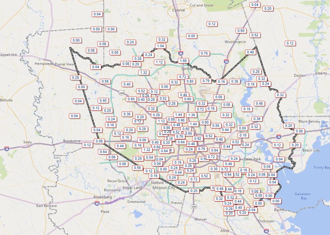
Areas near Spring and The Woodlands saw north of an inch and a half of rain, while parts of Galveston and Brazoria Counties saw virtually no rain at all. East Bernard (not shown) in Wharton County also likely received close to 2 inches of rainfall.
Today
The front is through, and showers continue in its wake. These showers may be a bit stubborn to end. Areas north and west of Houston will likely see brightening skies this afternoon. But showers could persist off and on elsewhere. We’ll struggle a bit in the temperature department today, with cloud cover dictating how warm we get. Those that see sunshine could push 70 degrees, while those under clouds and showers through early afternoon may not get much above the low-60s. Northeast winds will be noticeable, giving today a distinct autumn feel as they gust to 20 mph or so in Houston and as high as 35 mph near the bays and Gulf.
Weekend
Overall, if you have weekend plans, you’ll be fine in most cases. There’s a little nuance to touch on though.
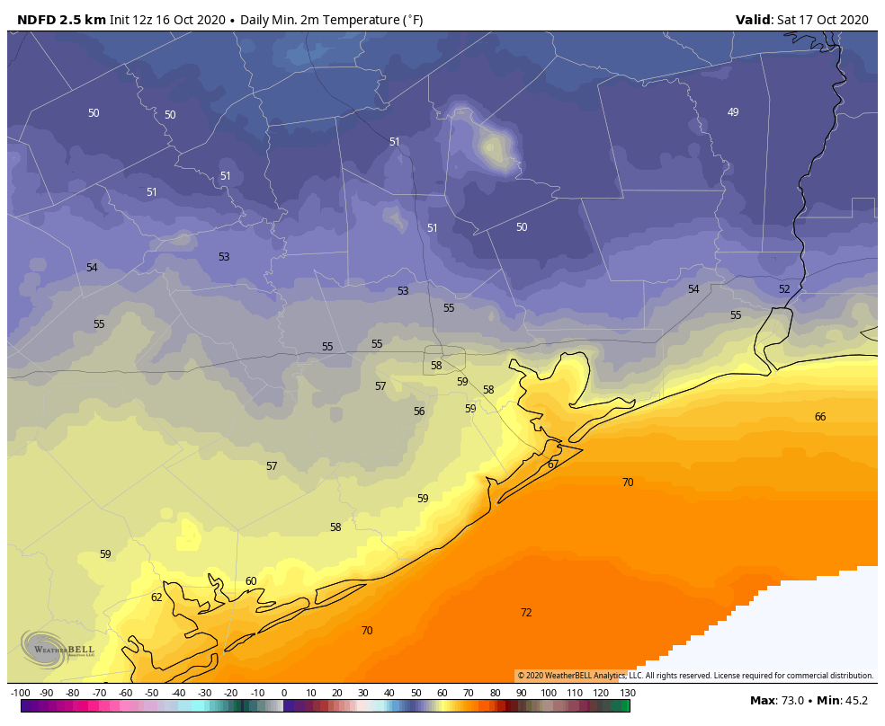
Saturday will be a bit of a toss-up day. The morning should be beautiful, cool and crisp, with temperatures generally in the 50s inland and 60s at the coast.
But we will see some cloud cover around, especially extending from southwest to northeast through the day. A little sporadic light rain or drizzle will be possible, mainly southwest of Houston. High temperatures should find their way into the upper-70s in most spots, perhaps 80 degrees or so with enough sunshine. Winds should be a more reasonable 5 to 15 mph.
On Sunday, the morning won’t be nearly as cool, with lows in the 70s at the coast and mid- to upper-60s inland. Onshore flow resumes, and you’ll notice building humidity by Sunday morning. We should see a mix of sun and clouds, and an isolated shower can’t be entirely ruled out. Looks for highs back firmly into the 80s in most spots.
Early next week
Monday should be a similar day to Sunday with warm temperatures, high humidity, and at least a chance for a passing shower or storm. Tuesday likely carries slightly better chances for scattered showers or thunderstorms. More of the same follows Wednesday. It’s a bit tough to pin down which days and times will have the highest rain chances, as we’re dealing with some fast moving disturbances that are difficult to time out this far in advance. But in general, early next week is clouds & sun, a chance for thunderstorms, and highs in the 80s, lows mostly in the 70s. Our next front is unlikely before next weekend.
Tropics
Eric’s touched on the tropics a bit this week. The bottom line is that we have nothing at all to worry about here.
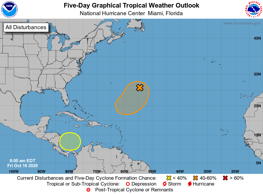
The Caribbean system may develop, but it would track due north and eventually northeast, away from the Gulf and probably away from the U.S. Another system seems likely to develop in the open waters of the Atlantic. The next two names on the list are Epsilon and Zeta.

Hypothetical question: What name would follow “Zeta”?
Eta, Theta, Iota would be the following ones.
Eta. The Greek alphabet doesn’t end with Zeta. It ends with Omega.
Getting back to Delta. If it were a normal name, it would be retired and not used again. But how do you retire a Greek letter?
I read an article that said “Delta 2020” would be “retired” but they would continually to use Delta in future years of necessary.
continue to use if necessary!
As Jean noted correctly, it would be retired as “Delta 2020,” but the name Delta would be cycled back through again if and when we do another season that gets to Greek letters. Now, I’m not 100% sure Delta 2020 would be retired, truthfully. Laura certainly will be. While impressive, I don’t know that Delta belongs in the hall of fame with storms like Laura or Harvey or Andrew. It’s kind of the next level down from there. But we’ll see what the powers that be determine.
I’d be perfectly happy if it didn’t get above 60 deg F until next May. Much disappointment lies ahead…
Eric or Matt – could one of you explain the crazy GFS-Para forecast model? It has the Caribbean system moving north to Cuba and then left into the Gulf and on to the Texas coast? No other model (not even the GFS does that). The GFS model has the system moving north up the eastern US coast. Why are they so different?
I have no idea truthfully. But there’s a reason we don’t use operational, non-ensemble models out past days 7-10. The GFS is known to do some weird things from time to time, and this just appears to be something like that because there is no real ensemble support for that kind of outcome.
Thank you for taking the time to answer my question.
A few more days like this and we’ll be wishing for summer
Oh dear god no.
Space City Weather… does EaDo mean East Downtown?