Yesterday ended up being a nice day after another cold morning. I wanted to highlight a couple superlatives from yesterday. At Bush Airport, we snuck down to 30°, once again, our coldest morning this early in the season since 1999 (11/3/1999). That’s our official tally for the date. Impressively, Hobby Airport got down to 32° on Thursday morning. It hasn’t been that cold this early in the year since 1969, when we hit 28° on November 15th!
30 degrees this morning at IAH; earliest we've done 30 since 11/3/1999 at Bush. It appears Hobby hit 32° this morning, which, if I'm reading the data correctly, would be the earliest freezing temp at Hobby since 1969! pic.twitter.com/Yd5gXjhErs
— Matt Lanza (@mattlanza) November 15, 2018
So for the greater Houston area, it was our earliest freeze in about 20 years, though for a few parts of the area, it was likely our earliest freeze in almost 50 years!
No more freezing temperatures to discuss for a little while, but we will be discussing some more active weather once again.
Today and Saturday
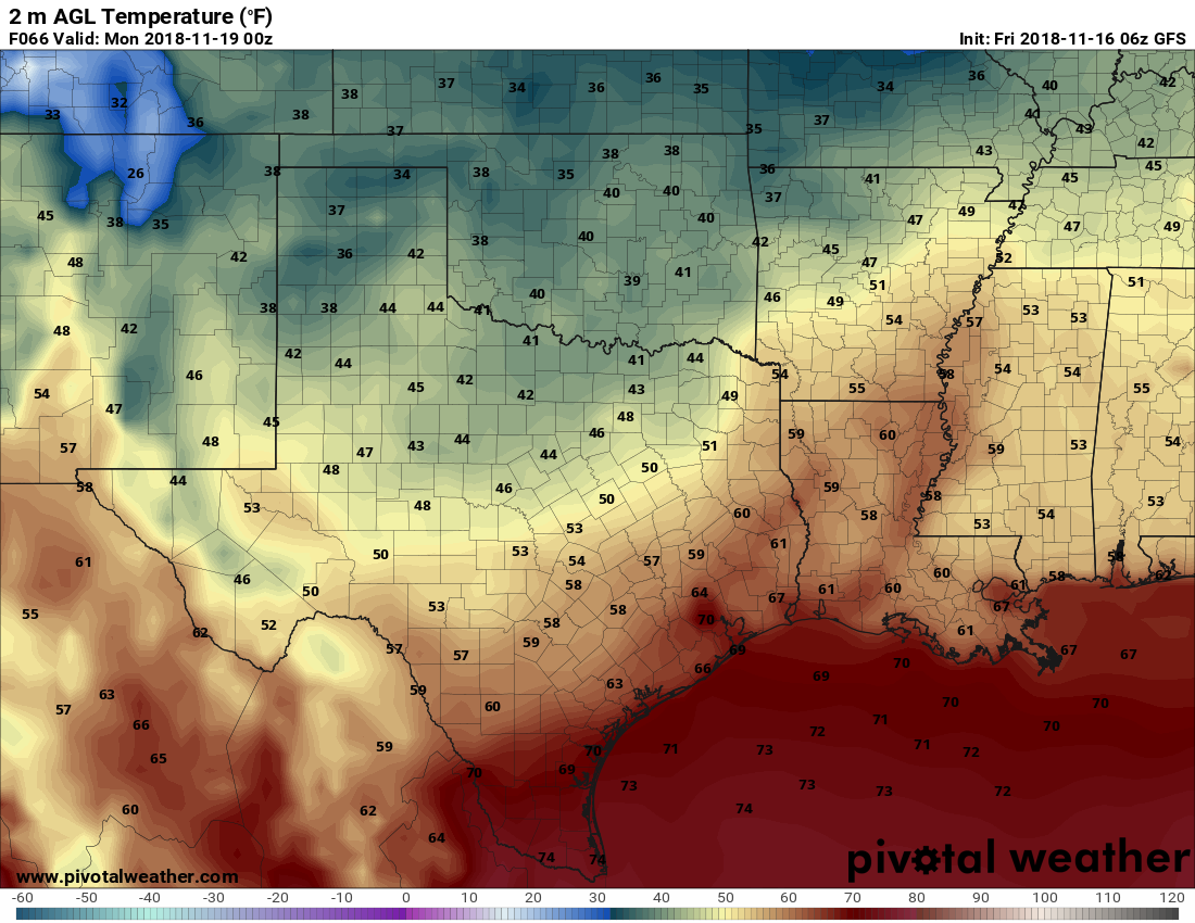
Other than some passing high clouds perhaps, today looks great. Spectacular, even. We’ll warm up into the middle or upper-60s in most of the area. A few spots could push 70 degrees. We added about eight to ten degrees to morning lows today, and I expect we’ll add another six to eight degrees on Saturday morning. Most folks will sneak into the mid-to upper-40s tonight, though a few locations may neglect to drop below 50 degrees.
During the day Saturday, we should see a few clouds rolling back into the area. So we’ll call it partly to mostly sunny. We should be able to hit or exceed 70 degrees on Saturday afternoon.

Sunday & next week
We can sort of break next week into two phases. The first phase is Sunday. Onshore flow will be full swing by Sunday, pumping in clouds and moisture. A few showers or even a rumble of thunder will be possible by afternoon, especially west of Houston. This is courtesy of a cold front approaching the region. The front should be able to push through, but exactly how quickly remains uncertain.
Look for Sunday to be cool for areas north and west of Houston and mild south and east. The front should eventually clear the area in the evening, cooling all of us back into the 50s or even 40s Monday morning. Monday will be cool and probably dry to start, but then the next phase of our weather takes over from here. I’d be lying to you if I told you we had high confidence in how it would play out.
Our best guess right now is that another atmospheric disturbance will travel into and through the state late Monday or early Tuesday. This will bring a period of showers or even some thunderstorms. We may catch a bit of a break later Tuesday into early Wednesday before another, slightly more vigorous disturbance passes by late Wednesday and Thursday bringing another chance of rain and storms. As of this morning, the Thanksgiving disturbance looks like it will pass offshore enough to keep any problems away. But given that we are still five to six days out, it’s our responsibility to remind you that this can change significantly between now and then. The timing is unfortunate (insert snarky comment about Houston and holiday rain here), and I think we will be dealing with changes to the forecast one way or another by Monday.
Right now, between all the systems slated to impact us Sunday through next week we expect around one to two inches of rain area-wide.
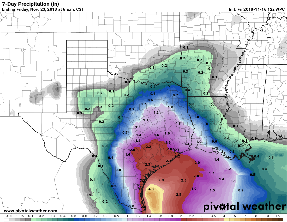
Areas closer to the coast or to the south of Houston could see higher amounts. Most of this falls with Monday and Wednesday’s disturbances. Again, details will change between now and then, so these rain totals may need to be adjusted. We will update you later this weekend or on Monday.
I hope the early cooling is part of a trend. I’d love a genuinely cold winter for a change. More snow days! More snuggling down inside! Maximum hygge!! A guy can dream…
I agree, love the cold! Maximum Gemütlichkeit:@)
did anyone see a giant meteorite last night? At about 9:15 I saw a giant fireball that was orange with green on the edges. I thought that it was a Roman candle.
Just to update, indeed there was a giant meteor over the region on Thursday evening at 9:21. The news reported it, and there were a few videos from dashcams and security cams. I used the word meteorite which I guess is not correct until it hits the earth. I don’t know if it made it to earth or not. It was brilliant and colorful, leaving a green-blue trail in the sky. So, if you saw it, too, you are not hallucinating
Is there any correlation between early freeze and Houston total winter temps/duration (heating degree days etc)? Or is it random.
Good question, Mark. So, this is very roughly scientific…it leaves something to be desired, so just be aware this isn’t perfect. I took the years with the 10 earliest freezes since 1950 in Houston. I then looked at where we ranked in the subsequent winter. Of the 126 years of data we have, those 10 years ranged anywhere from the coldest winter on record (1977-78) to the 104th coldest (or 22nd warmest). When you average where the years rank together, you get about 45th out of 126 years. So there is a skew toward colder than normal, yes. Not a guarantee by any means, but the odds would be tilted toward us leaning colder than normal.
Answers like this are what makes me read the comments. This website is what weather forecasting should be like. Honest, interesting, and imperfect science, explained clearly. I bet this is similar to what the the newspaper weather reports were like, back before the tv news started having people stand in a puddle and scream into the camera.
Never change!
Umm, not a scientific question, but I am planning outdoor feasting on Thanksgiving. What do you think? I am an optimist and my husband is a realist. We both want dry guests. Thank you for your best guess. Rentals have to be cancelled tomorrow.