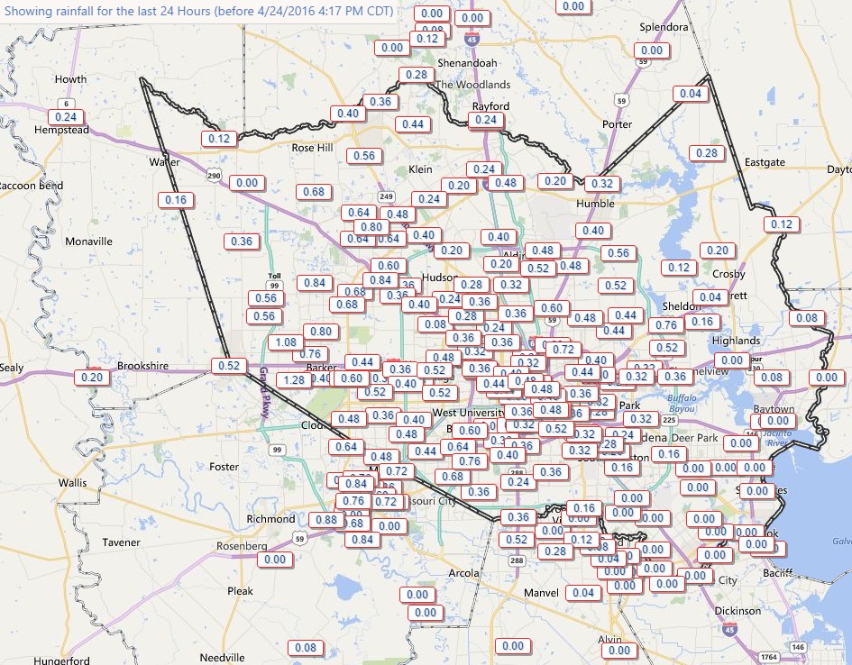
Unfortunately some of the showers moving over Houston today did develop into moderately heavy thunderstorms. Additionally, these storms moved over the western half of the metro region hard hit by rains six days ago, bringing as much as 1 inch of rain to some areas.
The good news is that the storms are moving steadily through, and the core of this system is now lifting north. I expect to see the remaining shower activity die down by this evening.
This should leave us with some relatively calm weather until Tuesday night, when another disturbance approaches. I remain more concerned about the potential for heavy rain this coming weekend, which I discussed this morning.
Thanks, Eric!
Coming down good here in Seabrook, let up then started again.
Dear Eric, Enjoyed a crawfish Boil Birthday Celebration in Kingwood today for Daughter #1 (of 5) at home of daughter in Kingwood. Fortunately we ate early and all departed about 3 PM. As Birthday Girl and I were returning home in her car, south on hwy59, nearing GRB, rains were so heavy we could barely see the lane marking and put on hazard lights- numerous others as well. Going 30mph, we proceeded with caution and realized no standing water. Thank God!
Got to 288 in good order and arrived home safely.
So Eric/Matt…help me out…the time is 7:45 pm, Sunday…I have received three “Extreme Threat Alert Messages” for the NWS…each message stated, “Tornado Warning in this area til 8:00 pm CDT. Take shelter now. Check local media. – NWS”…so I got locked on radar images of the Clear Lake area and did indeed see some “red” areas close by and fairly heavy rain near us close to Space Center and Eldorado Blvd intersection…I could not hear any freight train sounds indicating a twister in the area… might you all be able to help me understand what a message like that from the NWS means by “in this area”? And, I thought “Tornado Warning” meant one in the area had been confirmed, but I certainly could be wrong with that…thanks…Milt
Milt,
The NWS does not wait for tornado confirmation to send out warnings. When there is the appearance of a cyclonic circulation on radar, and perhaps other evidence, they will often send out a warning. I think the false alarm rate is about 50 percent. But if they waited until there was absolute confirmation (say, from a police officer on the ground) the warnings would come too late.
Copy..and do understand…we were prepared to jump in the tub and put a mattress over us…cat would not have been happy to be with us…
Where can I find the NWSWGRFC map for forecast flood severity scale? I have looked on the NWS web site and can’t find it so apparently I don’t understand the terminology. It’s a very useful map for those of us living across Hwy 6 from Barker Dam.
Thanks.
Dear Eric:
Is this low pressure system that is expected to drift over Texas this weekend even MORE powerful than the low that dropped all the rain on SE Texas on April 18?
No.
What Paul is asking you, Eric, is if Houstonians should expect even nastier storms than what we experienced last Monday. That is something I would like to know, myself.
I am confident the answer to that is no.
I am moving to Houston this weekend and will be driving. What is the best way for me to say on top of the weather inot the area?
Right here, Renae. I an promise you that Matt and I will be on top of things.
I’ve lived in Houston for 18 years and I can confirm this is the absolute best way to be on top of Houston weather.
Thanks!