After some rather nasty storms on Sunday afternoon and early evening, which brought as much as 3 inches of rain to Friendswood and sparked some tornado warnings, we’ll see quieter weather—for a bit.
TODAY and TUESDAY
We’ll see partly sunny and warm days, with highs rising into the mid-80s today and Tuesday. Over the course of the next two days we’ll see an increasingly strong southerly wind, which will help amp moisture levels back up over the area. On Tuesday we’ll hear a lot about the potential for multiple tornadoes and heavy rain over northern Texas and Oklahoma as a storm system crosses the central United States. It could get pretty bad for Dallas and points north. Houston appears likely to be on the southern periphery of this system. And as it moves eastward it could begin to affect the Houston region.
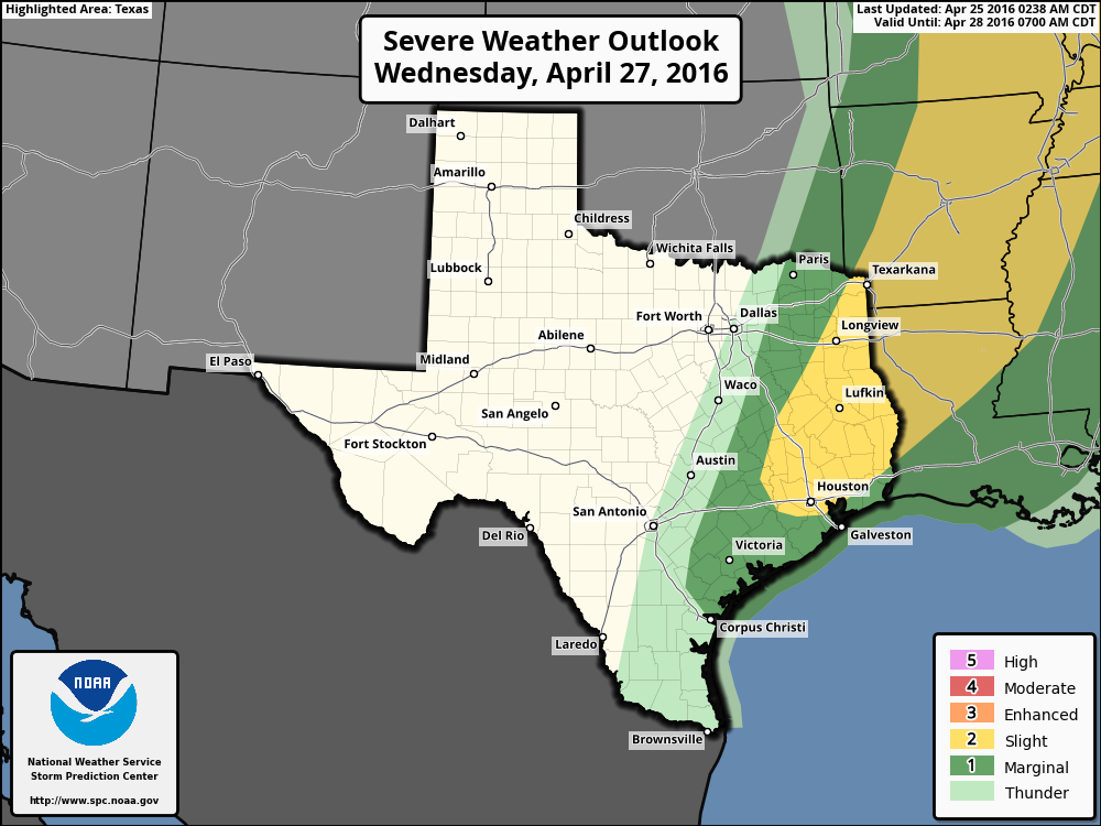
WEDNESDAY
Thus we will see the potential for thunderstorms and potentially tornadoes move into Houston on Tuesday night and Wednesday. Some locally heavy rainfall will also be possible. As you can see from the warning map above, northern areas of the Houston metro area are more likely to be affected than southern regions. With that being said, at this time I am not overly concerned about rainfall totals on Tuesday night and Wednesday. Bigger problems may come later in the week, however.
THURSDAY
We’ll likely see a break in the inclement weather on Thursday, with another warm day in the mid-80s.
FRIDAY and SATURDAY
Another upper-level storm system will move down across the United States, and into Texas. The forecast models are split as to where the heaviest rains will come. The GFS model generally keeps the heaviest rains—5 inches or more—north of Huntsville, whereas the European model brings much of this heavy rain down into the central Houston area.
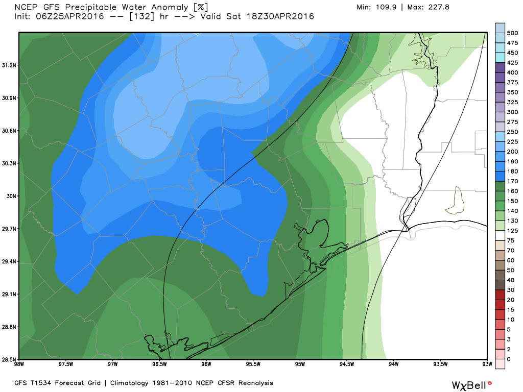
At this time all I’m comfortable in saying is that, by Friday afternoon or so, the potential will exist for heavy rain, and this will continue through Sunday morning. We just can’t say with any confidence where the heaviest rain will come in East Texas (which includes the Houston metro area). I would add that if you have outdoor plans on Saturday I would at least be thinking about a contingency.
NEXT WEEK
If there’s any good news it’s that the global models are both hinting at a fairly strong cool front to move through during the middle of next week. I’d like to see some more lows in the 50s before the onset of summer so let’s hope that happens.
We were planning to go from Houston to Austin for the weekend. Do you think we should consider another weekend?
Thanks.
At this point the storms will probably hit Austin from Friday night into Saturday morning. Saturday evening and Sunday look OK at this point.
News media was reporting last night that a tornado may have touched down in League City and that it would be evaluated by the NWS this morning. Please keep us posted on the results. Thanks.
Will do.
It definitely touched down! I watched it tear up trees, loft debris into the air and cause light damage to a couple roofs and various yard items like a trampoline. I took several photos… I live off of Tallow Forest St. in League City (W of 45 just N of 517).
Eric, now that my home is dry again, I have a question. I went to bed on Sunday night, expecting 4-10 inches of rain over a 2-day event over largely dry soil. Even though I flooded on Memorial Day last year, I expected this storm not to cause any major issues. At 4:30 I was placing sandbags and had water inside the house at 5am. My question, now that we are getting ready to fix a home that has flooded twice in less than 1 year: what happened? Or, to put it more proactively, what do I need to be looking for in the forecast to start pulling out the sand bags to cover every possible water ingress point to the house? Finally, is this an “el niño” connected event?
BTW, I am nowhere close to the areas with 15″ of rain, I am west of town around Memorial City.
Al,
El Nino is very weak now, so I would not blame this storm on that. Nor were the Memorial Day floods related in any way.
As to your other question, I don’t have a good answer. But Matt and I are going to look into these questions in the weeks ahead.