Our forecast remains more or less the same, with a slow warming trend before cooler weather returns by the weekend.
TODAY
It’s a very cold morning, with freezing temperatures over parts of the northern half of the Houston metro area. As high pressure moves off we’ll see only partly sunny conditions today, with highs in the mid-50s and a slight chance of rain tonight. Lows in the 40s tonight.
WEDNESDAY
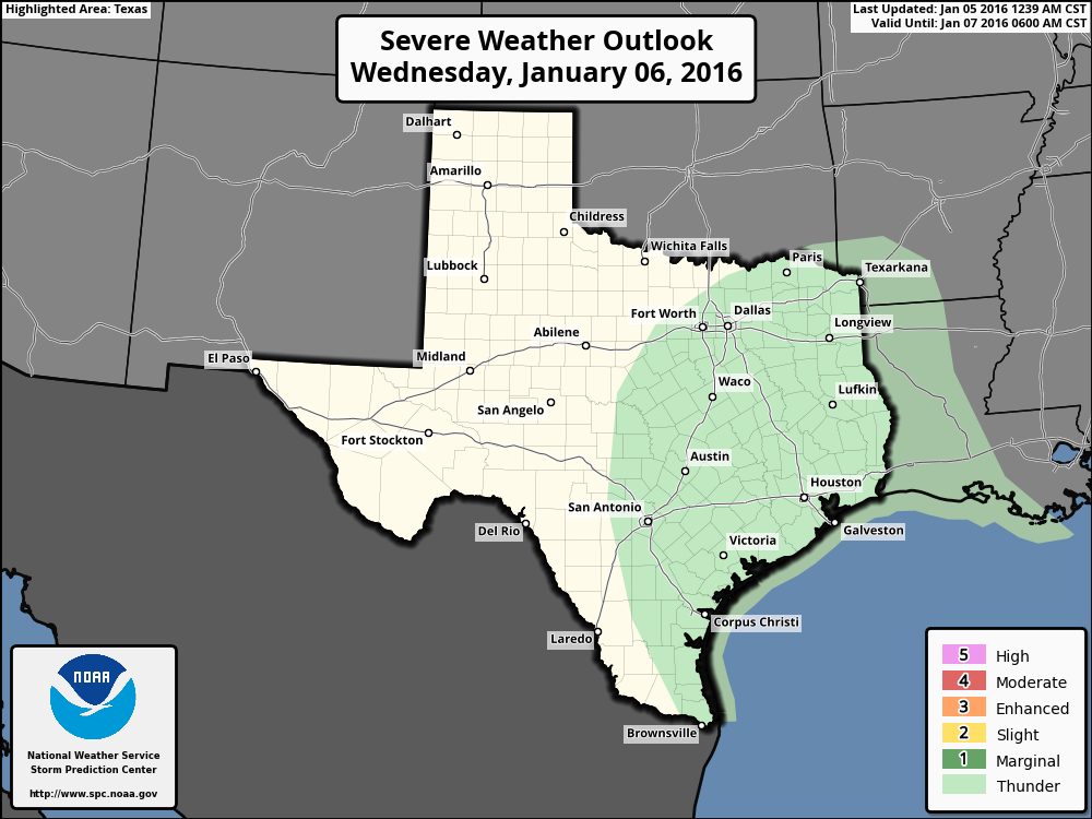
Wednesday, and especially Wednesday night, will see the best chance of rain as a low pressure system in the upper levels of the atmosphere moves through the area. I expect most areas to receive 0.5 to 1.5 inches of rain, with only scattered thunderstorms.
The Houston area is under only a very slight risk of thunderstorms on Wednesday night. (Weather Bell)
As promised, I’ll be providing daily weather outlooks for the Chevron Houston Marathon from now until race day, Jan. 17th.
At 13 days out there’s still not a whole lot we can say with confidence, especially because forecast accuracy after 7 to 10 days is pretty low even though forecast models run out to 16 days. With that said I’m feeling decent about not seeing abnormally warm conditions on race day, and we may very well see cooler than normal conditions. So let’s discuss what we know, and what we don’t.
Perhaps the best way to gauge conditions from this far out is to look at the ensemble runs of global forecast models. That is, the GFS and European models are each run about 50 different times with slightly different starting conditions. This gives a range of outcomes, and from looking at all of these ensemble runs we can get some probabilities on conditions. For example, do most of the ensemble runs show warmer or colder conditions?
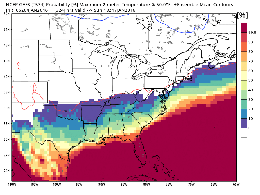
The GFS model is colder than the European during the next two weeks as it predicts a major Arctic outbreak across Texas in about 11 days time. If this event occurs we could see very cold temperatures on marathon day, like in the low 30s on the morning of the run. (Is that too cold for most people?)
Anyway, the model forecasts the probability of a high temperature greater than 50 degrees Fahrenheit at noon to be 30 percent, or less. This is good, obviously, because anything warmer than 50 degrees can become uncomfortable after several hours of running.
Probability of a temperature greater than 50 degrees at noon, Jan. 17th. (Weather Bell)
It has been cold during the last week, but we still haven’t had really, really cold weather yet. Houston’s first Arctic front may come later this month, however. We are certainly due.
LATE FREEZE?
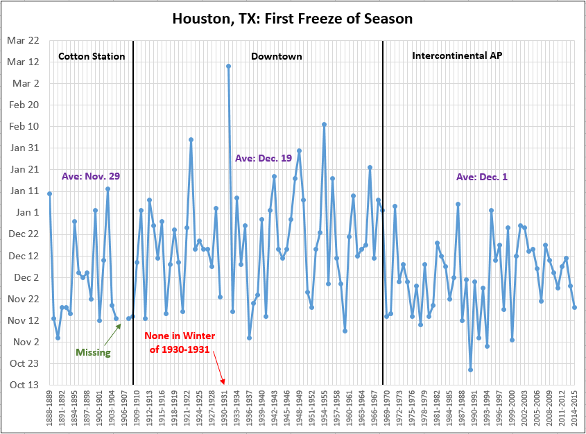
Houston first freeze climatology. (Brian Brettschneider)
Houston is more than a month late for its first freeze of the season. Since the official weather station moved to Bush Intercontinental Airport in 1969 the first freeze has come, on average, on Dec. 1. It’s never been later Jan. 5th, according to data collected by Brian Brettschneider. That’s tomorrow.
TODAY and TUESDAY
Conditions today and Tuesday will be similar to Sunday, with mostly sunny skies and high temperatures in the upper 50s. Tuesday morning will be cold, but I expect most of the area to remain above freezing. If that’s the case this winter will bring the city’s latest freeze since the 1960s.
Good morning. One more gray day before the Sun returns. We’ll also see better chances for heavy rain next week.
TODAY
Light rain showers are moving into the region from the southwest, and I expect that by this afternoon or evening most parts of the Houston area will see at least some mist, if not light precipitation. Nothing to write home about, though, and highs will struggle to reach 50 degrees.
SUNDAY
The aptly named Sunday will see the return of the Sun. Finally. After a cold start at about 40 degrees, highs will climb into the mid-50s. Should be a really nice day after what we’ve been experiencing.
MONDAY-TUESDAY
Partly to mostly sunny skies and cool days in the 50s will remain the order of the day through Tuesday afternoon or evening. Tuesday morning will be quite cold under clear skies, but I don’t think most of the Houston metro area will reach freezing temperatures. We’ll at least be close, however.