Strong storms over central Texas should approach Houston on Monday

Areas along the I-35 corridor are getting hammered by storms today, some of which are producing rainfall rates in excess of 3 inches per hour. The system is not moving much either. It all is likely a preview for what’s to come later this week for parts of Houston. However it should be stressed that predicting how much rain, and where the heaviest storms will occur remains highly uncertain.

TONIGHT

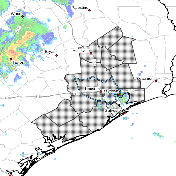
So far today only scattered, light to moderate showers have developed over the Houston metro area, particularly the east side. That’s likely to remain the case throughout the evening. I don’t anticipate any severe weather for the rest of today because most of the action will be off to the west of Houston.

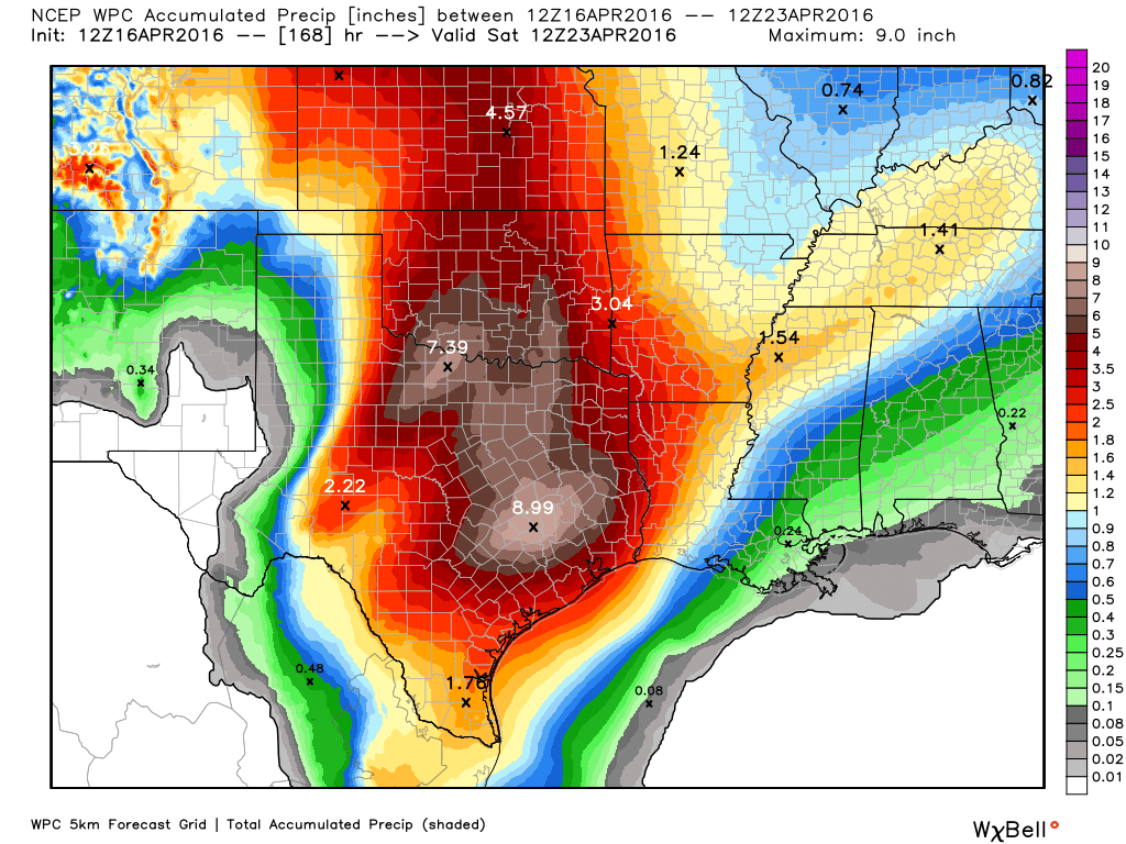
However as that system over central Texas continues to move eastward, the Brazos Valley including College Station should begin to see its effects later, perhaps before midnight or shortly after. Expect 3 to 6 inches of rain (if not more) during the overnight hours for parts of Texas between Houston and Austin.

MONDAY and TUESDAY

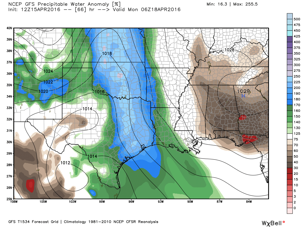
Sometime on Monday, perhaps before noon, Houston will see the main area of showers and thunderstorms approach from the northwest. With ample moisture (being recharged by the Gulf of Mexico) and a slow-moving low pressure system parts of the Houston metro area will very likely see the same kinds of intense rainfall rates as are occurring in central Texas today.

A flash flood watch is in effect for Houston through Tuesday morning. (National Weather Service)

See full post

Heavy rains coming, flooding possible especially along the Brazos River

Stepping outside one can feel the moisture in the air, and it most definitely augurs what is to come—heavy rain. So let’s discuss that.

TODAY

Strong winds from the southeast have done their work, increasing atmospheric moisture levels over the region. They’ve also led to a Coastal Flood Warning from the National Weather Service, pushing seas 2-3 feet above normal and flooding low-lying areas. The warning remains in effect through 1 p.m. on Monday.

Large scale features are still coming together for very heavy rains across parts of the eastern half of Texas today, Monday and Tuesday. There are near-record high levels of atmospheric moisture, a potent-upper level feature, and an inflow of moisture from the Gulf of Mexico to recharge the moisture with atmosphere. None of these large-scale patterns will tell us exactly where the heaviest rains will fall, however, as that will be due to more localized features like the locations of slow-moving boundaries related to individual storms. I write all of that to say this: There is the potential for very heavy rain, but we can’t say exactly where the storms will bomb out.

Depiction of the upper-level low feature driving storms. (NOAA)

See full post

Flash flood watch likely with coming storm system

Here’s the latest on storms likely to bring heavy rain to Houston during the period of Sunday night through Tuesday.

TODAY

It’s cloudy and breezy this morning, and we’re going to see more of the same throughout the day. Winds should increase to the point today where we see gusts up to 25mph, and those southeasterly winds will bring lots of atmospheric moisture inland. Highs should reach into the upper 70s today and there will be a slight chance of light rain later today and tonight.

SUNDAY

Sunday will start out a lot like today, mostly cloudy, breezy and with similar temperatures. However a potent upper-level low pressure system will move into west Texas and should bring heavy showers and thunderstorms over central Texas, from Austin to Dallas, during the middle part of the day. Light to moderate rain will be possible in Houston during the afternoon and evening hours, but the potential for heavy rain really does not arrive until Sunday evening or during the overnight hours. For the most part travel on Sunday, during the day, should not be affected in the Houston region.

MONDAY

Some flooding is possible Monday morning, with the potential for heavy rain during the overnight hours on Sunday. However it now appears the best chance of strong showers and thunderstorms, and potential flooding, will come later on Monday and Monday night. In addition to ample moisture flowing off the Gulf of Mexico and the upper-level low pressure system, there will be divergent winds in the upper atmosphere that really force moisture at the surface to rise. This does not guarantee rainfall, but it does tell us that nearly all the conditions needed to produce very heavy rains will be in place.

NOAA's latest rainfall accumulation forecast shows the heaviest rain just to the northwest of Houston. (Weather Bell)
NOAA’s latest rainfall accumulation forecast shows the heaviest rain just to the northwest of Houston. (Weather Bell)

See full post

Heavy rain event on tap for at least part of the Houston area

Well, it’s a beautiful day today. Sunny, cool breeze, nigh perfect. But it’s springtime, and that means the potential for heavy rain and storms, and later this weekend Mother Nature is going to deliver. I want to give an idea of what to expect.

SUNDAY

For the most part, during the daytime in Houston on Sunday, I expect to see only light rain. Not that it’s going to be particularly pleasant outside, with southeasterly winds gusting to 25 mph. But the storms should hold off until at least the mid- to late afternoon hours. However by Sunday night a potent upper-level low pressure system should force air in a very moist atmosphere to rise, and create conditions conducive for very heavy rainfall. (The second day of the MS 150 ride has already been canceled as areas in central Texas will experience these conditions earlier than Houston.)

There’s still no consistency in terms of location for the heaviest showers, but while some areas may receive just light rain, other parts of the area get 2 to 4 inches, if not more, during the overnight hours. Whatever your going to do Monday morning, best to plan on the possibility of needing extra time. Hail and damaging winds are also possible with these overnight storms.

Precipitable water forecast for Sunday, at midnight, shows 200 to 250 percent above normal levels of moisture in the atmosphere. (Weather Bell)

See full post