Tropics heating up: One storm may track toward Florida this weekend

As one would expect toward the end of August, the Atlantic tropics are starting to heat up, and we may see both a Gaston and a Hermine within the next week. As of 1pm CT on Monday, here’s the state of play in the Atlantic tropics.

(National Hurricane Center)


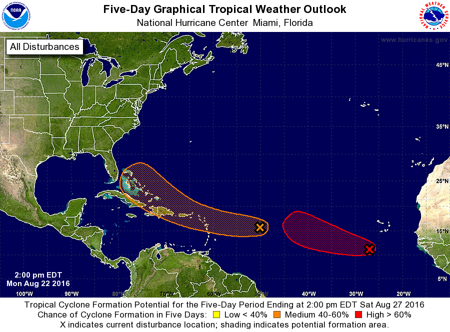
The red blob on the right is Invest 90L, and it’s soon to become Tropical Storm Gaston. I feel pretty confident that that’s all we’re going to gave to say about Gaston as a threat, because it has the look of a “fish storm,” meaning the system will probably recurve before it reaches the United States. We may have some concerns down the road about this being a threat to Bermuda, but I don’t think it gets that far west.

So what about the other storm?

Unfortunately we can’t be so dismissive about the orange blob, which is Invest 99L. The system remains rather disorganized right now, and due to the influence of dry air the National Hurricane Center only gives 99L a 50 percent chance of developing into a tropical storm or depression during the next five days.

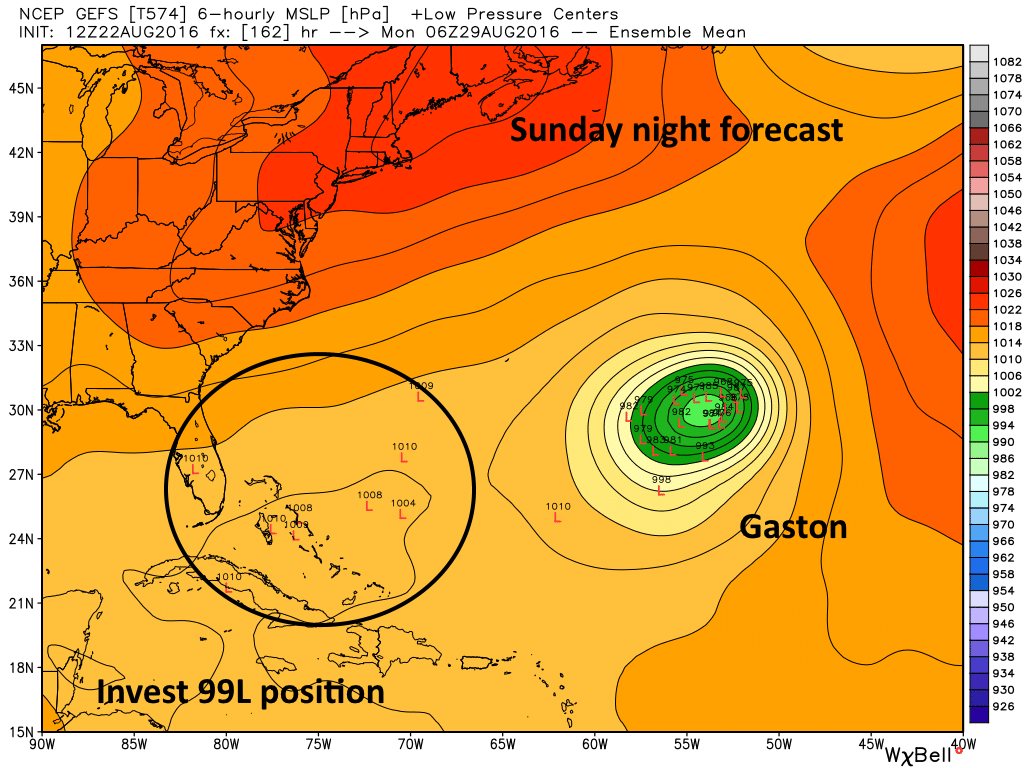
While the system may not develop it’s expected to drift toward the Bahamas by this weekend. Here’s a look at the GFS model forecast positions for the “low” associated with 99L by Sunday night:

(Weather Bell)
GFS model forecast for Sunday night. (Weather Bell)

See full post

Drying a bit this week in Houston, but “mild” August weather to continue

It has been quite a different middle of August for the greater Houston region. During the last eight days the high temperature has stayed in the 80s for six of those days, with a maximum of 92 degrees. And the rain. We’ve had lots of it. The greater Houston metro area has recorded 4 to 16 inches of rain during the last two weeks—an uncharacteristically wet spell for the dead of summer.

Here’s a rainfall accumulation map for the last 14 days:

Rain totals over the last 14 days in the Houston area. (NOAA)

See full post

Severe storms west of Houston, one more wet bout ahead for the city

It has been a partly to mostly sunny day for much of the Houston with a few rain showers developing across the city. But the second half of the weekend and into Monday looks notably wetter.

Saturday night

For tonight heavy rain will remain to the west of Houston, most concentrated over the Hill Country. A stalling cold front along with ample moisture will set the table for potentially flooding rains in the San Antonio and Austin areas. Forecast models support the idea of some areas receiving in excess of 10 inches of rain between Saturday morning and Sunday night.

Excessive rainfall outlook through 7am CT on Sunday. (NOAA)

See full post

Rinse, repeat cycle in Southeast Texas

We are firmly in what I like to call a rinse and repeat cycle here in Houston. Showers and storms have been resilient much of this week, and with that in mind, I’d expect we see another round of storms today.

While not unprecedented, our current “cool” streak continues to lengthen. Yesterday marked five straight days below 90°, which hasn’t happened within August since 2001. If we manage to avoid 90° again today, it will be the first time in 20 years that we’ve accomplished six in a row in August.

Today

Radar is quiet this morning, with just a couple showers at the coast, perhaps even fewer than yesterday. Similar to Thursday though, with the sea breeze spreading inland from late morning into early afternoon, showers and storms should fire up over a good chunk of the area. We may see locally heavy rain as this happens. Also like yesterday, we could see locally high water on some area streets, especially those typically prone to flooding. It shouldn’t take a lot of rain to accomplish this. Storms will keep moving though and it shouldn’t rain in any one place for too terribly long. All in all, similar to Thursday, but perhaps a bit less coverage/intensity than we saw yesterday.

Forecast radar from the HRRR today shows scattered afternoon showers  & storms, though perhaps a bit less coverage than we saw Thursday. (Weather Bell)
Forecast radar from the HRRR today shows scattered afternoon showers & storms, though perhaps a bit less coverage than we saw Thursday. (Weather Bell)

Temperatures today will be contingent on how quickly the rain arrives. We still managed 88° yesterday despite a good deal of cloud cover in the morning, but with rain arriving  just after Noon, temperatures were cut down. So upper 80s to around 90° is reasonable for today. If rain arrives a little later, we could break our 90-free streak today.

See full post