Rains ending for Sunday, but moderate rains return Monday before this mess clears

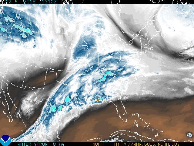
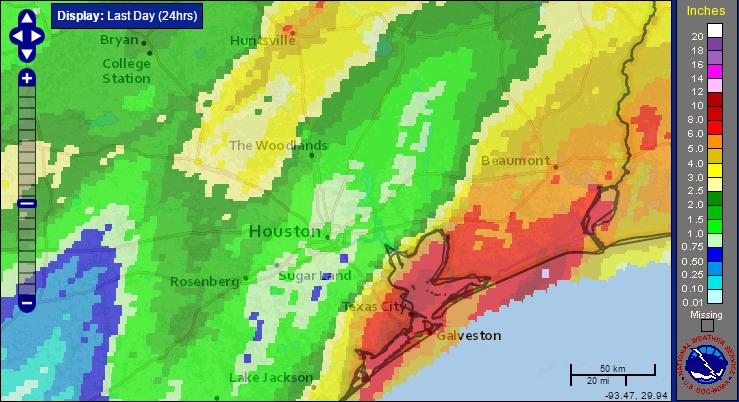
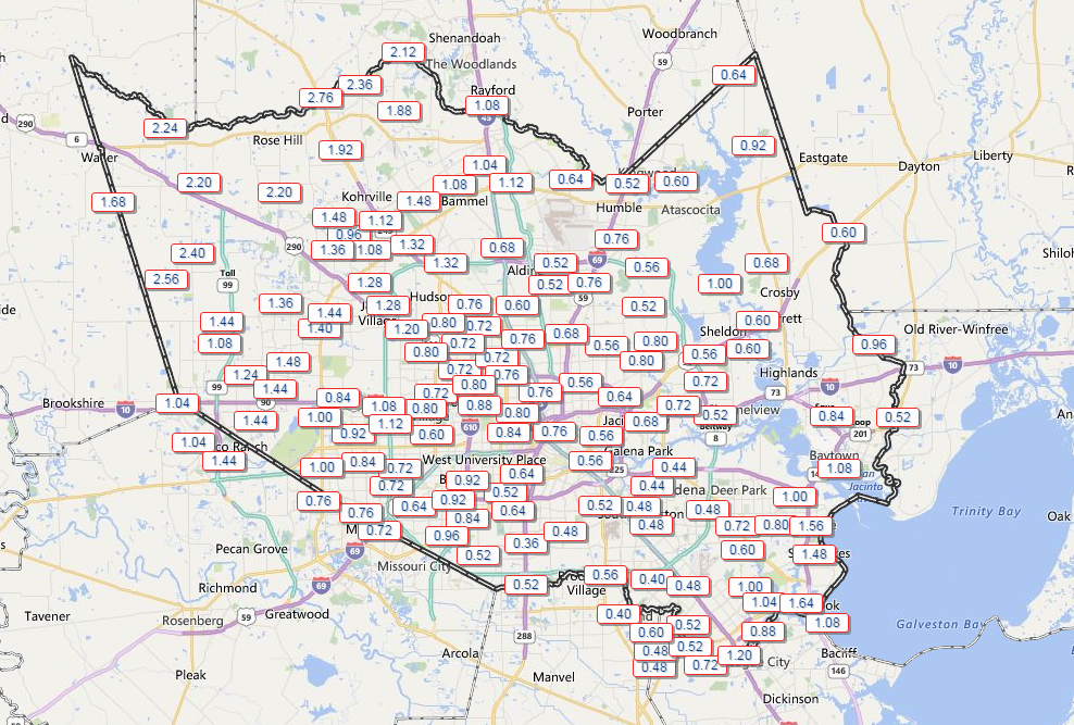
After steady, light to moderate rain this morning and early afternoon across Houston, showers have ebbed across the region as we go toward evening. Fortunately today only brought an additional 0.5 to 2 inches for pretty much everyone, which was manageable even for the coastal areas hard hit on Saturday.

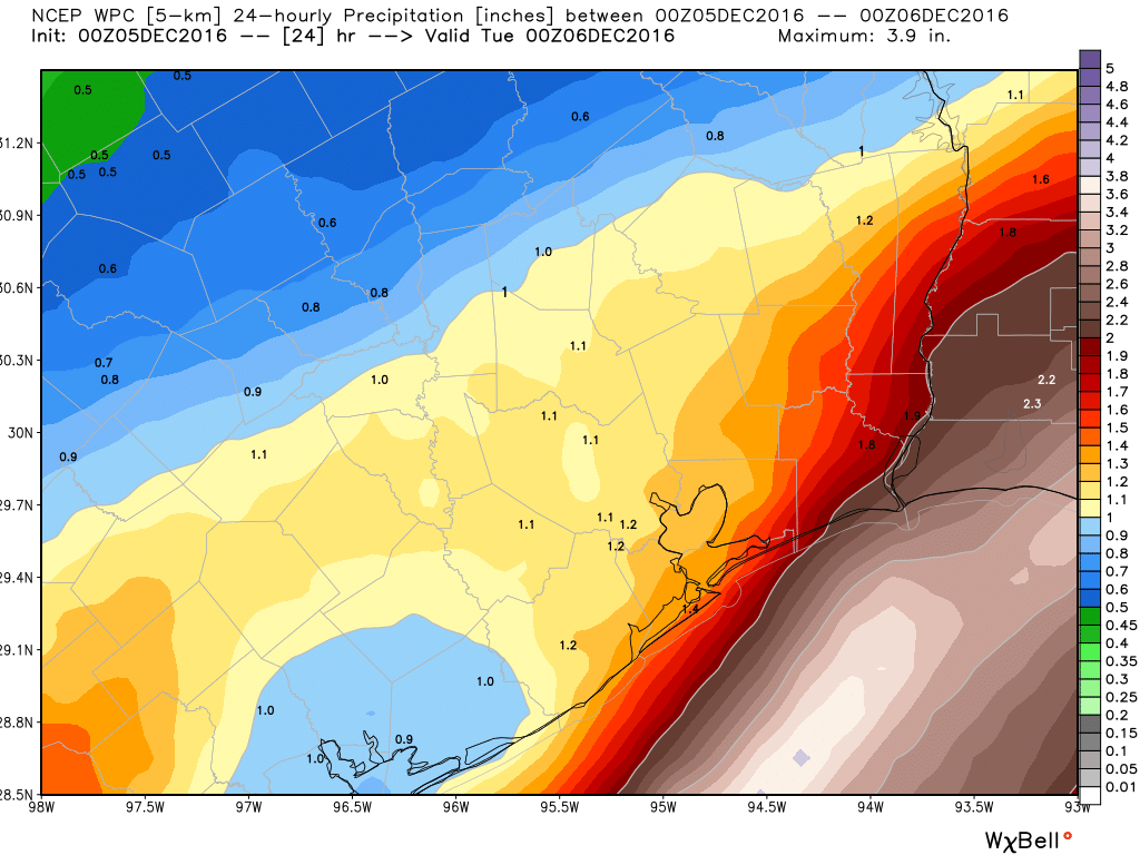
It seems likely we’ll remain mostly dry this evening, but there’s one more round of rainfall coming as low pressure lingers along the coast on Monday. Fortunately this event doesn’t look particularly extreme for Houston, with 1 to 2 inches of rain, maximum, likely falling between late Sunday night and late morning or early afternoon on Monday. So while your commute into the office may be soggy on Monday morning, I wouldn’t look for any significant flooding problems.

NOAA rainfall accumulation for the period from Sunday evening through Monday evening. (Weather Bell)
NOAA rain accumulation forecast for Sunday evening through Monday evening. (Weather Bell)


After the rains end Monday, look for a cool night down around 50 degrees, and then quite a pleasant day on Tuesday, with highs in the low 70s. Our next cold front remains on track for late Wednesday or so, and it will be a really strong one. I’ll have full details in Monday morning’s update.

Posted at 4:45pm CT on Sunday by Eric

More rain on the way for flooded coastal regions of Houston

Good morning. The greater Houston region experienced very heavy rains on Saturday, particularly along the coast. With 7.68 inches, officially, Galveston recorded its single wettest day during any winter month, on record. Just inland in Texas City conditions were more grave still, with as many as 11 inches of rain falling. Parts of Galveston Island, Tiki Island, and La Marque all experienced significant flooding, and a Red Cross shelter was established in League City at Bay Harbour UMC, 3459 Deke Slayton Highway, for affected residents.

After a relatively quiet Saturday night, storms began moving into the Houston region a couple of hours before sunrise on Sunday, setting the stage for another wet morning. Due to lower pressures offshore, moist Gulf air will continue to flow inland at the surface, and at the same time in the higher levels of the atmosphere there is a pronounced flow of moist air from the west. The net effect of this is a water vapor “highway” flowing into Texas from the southwest, up through the eastern half of Texas and along the coast.

Behold, the water vapor highway in this enhanced satellite infrared imagery. (NOAA)

See full post

Flash flood warning for some coastal areas as heavy rains continue

Grim, gray weather has persisted across the Houston metro area on Saturday, but by far the heaviest rains have developed along the coast, where as much as 10 inches of rain have fallen in the last 24 hours. The following map shows estimated satellite rainfall accumulations through the middle of Saturday afternoon:

Rain accumulation during the 24 hours preceding Saturday afternoon. (NOAA)


Officially, at of 4:15pm CT, the city of Galveston has recorded 6.14 inches of rain on Saturday, and when the city reaches 6.31 inches it will surpass Dec. 17, 1995, as the wettest December day ever recorded on the island.

Rest of today

A flash flood watch remains in effect for the entire area through Sunday evening, but as we’ve seen the heaviest rains have set up along the coastal counties, that’s where the biggest concern lies. Accordingly a flash flood warning is in effect through 5:45pm CT on Saturday for northwestern Galveston, and northeastern Brazoria counties. Grounds there are now fully saturated.

Area of flash flood warning in effect until 5:45pm CT on Saturday. (National Weather Service)

See full post

Houston under a Flash Flood Watch through Sunday

Good morning, everyone. The National Weather Service in Houston has posted a Flash Flood Watch for the entire region through tomorrow evening. As expected, conditions will become more favorable for flooding to occur in the hardest hit parts of the area as we go deeper into today, tonight, and tomorrow.

The NWS hazards map as of 8:30 AM shows a Flash Flood Watch posted for just about the entire region. (NWS)
The NWS hazards map as of 8:30 AM shows a Flash Flood Watch posted for just about the entire region through Sunday evening. (NWS)


Rainfall since yesterday afternoon across the area has been mostly manageable to this point. Northwest Harris County has seen 1-3″, while central and southeast portions of the county have received about a half inch to perhaps up to 1.5″ of rainfall.

An average of about 1-2" of rain has fallen over much of the area since yesterday. (Harris County Flood Control)
An average of about 1-2″ of rain has fallen over much of the area since yesterday. (Harris County Flood Control)


Outside of Harris County, Galveston has already set a daily rainfall record for today with over 4″ reported as of the 8 AM observation.

See full post