Summer finally ends, winter definitively begins

Summer, which began March 13th with a high of 87 degrees and remained persistently alive through the sultry months of September and October, died on Thursday morning of winter-like causes. She was eight months old.

Today

It kind of feels like summer finally died, right? With the forceful arrive of a cold front early this morning, Houston has definitely moved into a winter-like pattern. Highs this morning in the mid-50s will slowly fall throughout the day, and gusty winds will blow all day. Harris, Fort Bend and Wharton counties, as well as those counties immediately along the coast, are under a wind advisory through 6pm CT with gusts up to 35mph possible.

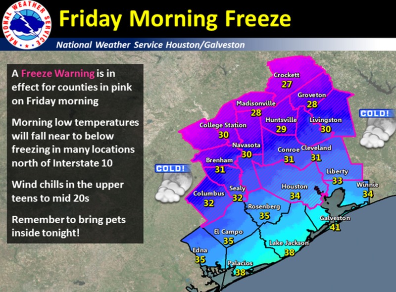
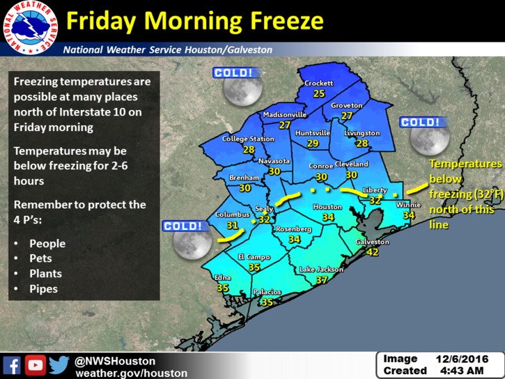
Tonight Houston faces the possibility of its first freeze. Harris and inland counties are under a freeze warning tonight from midnight through 9am. A freeze is most likely for those north of a line from Katy to Spring, but please remember there are a lot of factors at work here. The potential for some clouds, and moist ground (which will retain some warmth) may mitigate against the possibility of a freeze for these areas. In any case, tonight will be the region’s coldest since last winter.

Friday morning's freeze possibilities. (National Weather Service)
Friday morning’s freeze possibilities. (National Weather Service)

See full post

Strong winds likely Thursday as a “real” front moves into Houston

Good morning. Cool ground and calm winds are producing some patchy fog across the Houston area near Galveston Bay and a few other locations. This should persist until 8 or 9am CT this morning. On a related note, Matt and I want to wholeheartedly thank all of the supporters who bought t-shirts to support the site, and made donations to support our work. The fundraiser was a tremendous success. Look for your t-shirts to arrive a few days before Christmas.

Today

Expect mild conditions today, with partly to mostly cloudy skies and high temperatures in the upper 60s. With only a modest amount of moisture pooling ahead of a strong cold front, conditions won’t be ideal for rain showers this evening and during the overnight hours, and most areas probably will only see a tenth of an inch, or two.

Wednesday night and Thursday

A cold front racing across the plains states today should reach northern parts of the Houston area before or around midnight, and sweep through the city and be off the coast around, or shortly after sunrise Thursday. We’re going to wake up to blustery, cold conditions with temperatures generally around 50 degrees, and feeling quite a bit colder due to winds gusting to about 30mph for inland areas, and up to 40mph along the coast. Highs Thursday are unlikely to top 50 degrees and will fall during the afternoon hours.

Dewpoint gradient on Thursday morning, from negative numbers on the upper plains to the 60s along the Texas coast. (Texas Tech)

See full post

Near freezes? Highs in the 40s? Welcome to winter, Houston.

Good morning. It’s cool across the region this morning, with lows starting at about 50 degrees. But this is only the beginning of winter in Houston…

Today

The radar is clear this morning, but with virtually no wind and the moist ground, expect some low-lying clouds to persist for a few hours. After the fog burns off we’ll see mostly sunny skies today with high temperatures around 70 degrees—a bit warmer closer to the coast and cooler for inland areas. A weak cool front arrives later today, which will allow for temperatures tonight to again fall to around 50 degrees.

Wednesday

The front will keep temperatures moderate on Wednesday, with partly sunny skies and highs near 70 degrees. Rain showers should hold off until Wednesday night, when there may be a broken line of storms along with, or just ahead of a strong cold front moving through the Houston region. I’m not expecting much accumulation.

Thursday

Low temperatures on Thursday morning will be around 50 degrees, and as the front blows in they’re not going to rise during the daytime hours. As the season’s first real blue norther we’re going to see strong, gusty winds out of the north beginning early Thursday, with gusts perhaps exceeding 30 mph along the coast. The winds should continue for most of the daylight hours. Temperatures will probably fall during the afternoon hours, and lows Thursday night will be the coldest of the season.

Will it freeze? I’m still betting that enough clouds linger Friday morning to keep most of the Houston metro area just above freezing. Here’s the latest forecast map from the National Weather Service as to their best guess for a freezing line.

(National Weather Service)

See full post

Goodbye rain—hello Jack Frost

Note: Today’s the last day of our fundraising campaign to support Space City Weather in 2017. You can help by buying a t-shirt, or making a donation. For businesses, we also have a handful of monthly sponsorship opportunities still available for the first half of the year. If you can help, Matt and I really appreciate it! Now, on to the forecast, and our looming encounter with Jack Frost.

Monday

The rain’s almost over, and most of us are probably good and ready for that. As previously noted, on Saturday Galveston set a record for daily rainfall with 7.68 inches, for any winter day, in any winter year, in more than a century of records. Texas City faced significant, widespread flooding. All told, here are the estimated accumulations for rainfall from Friday evening through Sunday for the Houston metro area.

Rain totals from Friday through 5am CT on Monday. (NOAA)


As expected one final round of showers is moving through the metro area this morning, but the rainfall rates are low enough with the fast-moving storms for them to just be nuisance showers rather than threatening any kind of significant flooding in the Houston metro area. Expect the flash flood watch for Harris and the coastal counties to expire at noon CT today. As the upper-level low pressure system moves out of the Houston area today expect the rain showers to end as well, drying out from the southwest to the northeast. For today, the severe weather chances have moved off to the east, to the Gulf regions of Louisiana and Mississippi.

See full post