Houston Marathon forecast at 11 days: Still trending warm

Good afternoon. Here’s another update on weather for the Houston Marathon, and unfortunately the outlook at this time still favors warm conditions for the morning of January 15.

The GFS model

The North American model is downright warm. According its ensemble output, the GFS model forecasts a 0 percent chance of low temperatures 40 degrees or below on Sunday morning, which would be ideal for long-distance running. Conversely, the model predicts a 60 to 70 percent chance of a high temperature of 70 degrees or above that day. This still leave some wiggle room, but the outlook is not good. Essentially we’d be looking at start-time temperatures in the 60-65 degree range with high dewpoints.

The European model

The European solution is slightly more optimistic. The graphic below is busy, but instructive, so let’s take a moment to explain it. The bottom panel shows “minimum” temperature forecasts for a given six hour period. I’ve indicated the period for Sunday morning’s low temperature, and the range of 50 ensemble outcomes peg it anywhere from 30 degrees to 70 degrees.

However the highlighted green area shows the most likely range of temperatures that morning, from the upper 40s to the upper 60s (the model average is 59 degrees). Similarly the model’s most confident range of high temperatures on Sunday afternoon runs from 60 to 75 degrees.

15-day European model ensemble output. (Weather Bell)

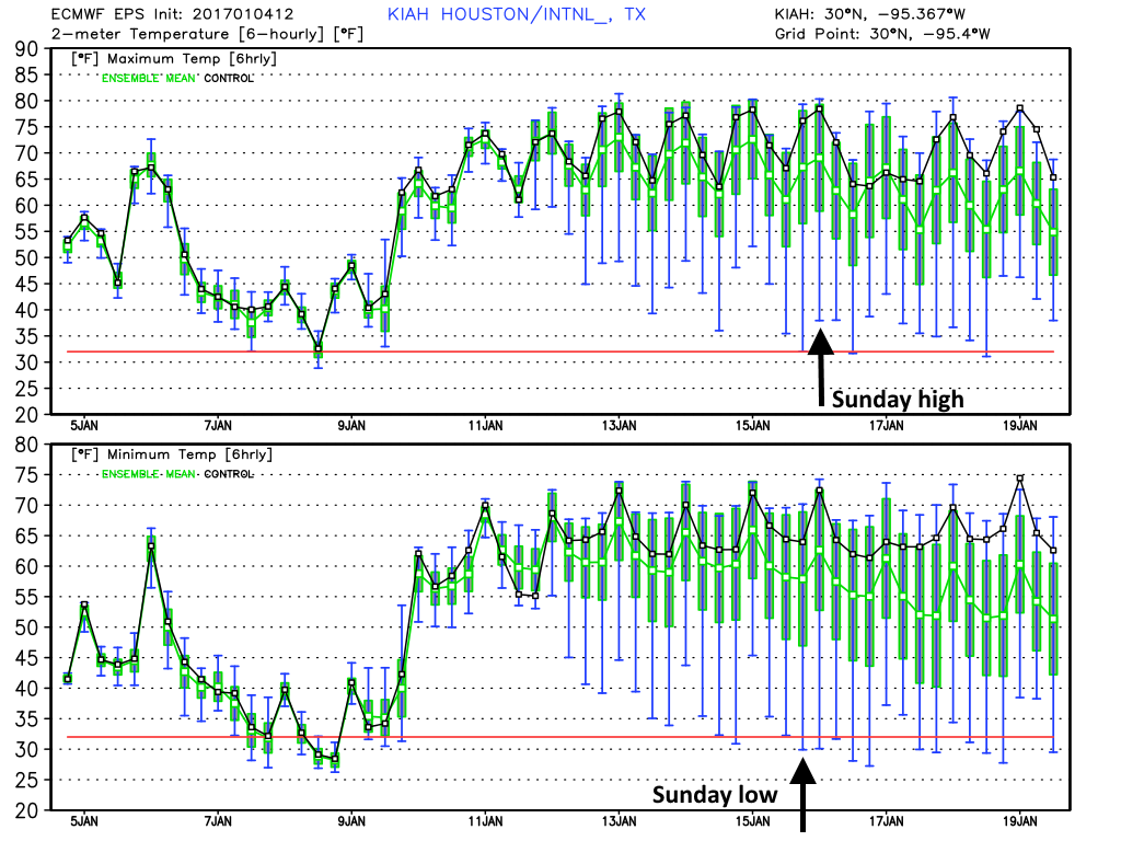
My take on the European model is that it’s forecasting about a 50 percent chance of significantly warmer than normal temperatures, 60 degrees or higher at race time. There’s probably a 25 percent chance of lows from 55 to 60 degrees, and a 25 percent chance of lows below 55 degrees (fingers crossed!).

The only positive thing I can say is this: We’re still nearly 11 days away from marathon day. That is a long time in weather forecasting, and predictions this far out are simply not locked in, even when the models seem pretty consistent. While a warm race day is certainly most likely, it is far from certain. But damn, I have to say the prospect of running a race in the 60s and moderate to high humidity is very, very far from enticing.

Tomorrow I’ll start looking at rain chances as well.

(Space City Weather is sponsored by Westbury Christian School for this month)

Posted at 4:20pm CT on Wednesday by Eric


Very cold weekend ahead for Houston, light freezes possible

Good morning. It’s in the 40s across Houston this morning, and we’re now going to remain in a cooler pattern through the weekend, with a light freeze possible on both Saturday and Sunday mornings.

Today

Northerly winds will keep conditions across the area winter-like today, with highs likely rising only into the mid-50s under partly sunny skies. Look for another cool night tonight in the mid-40s.

Thursday and Friday

Winds should veer back out of the south on Thursday during the daytime hours, and with some moisture in the air we can’t rule out a few scattered showers along with highs in the low 60s. Accumulations will be slight, however. A cool front will move into Houston later on Thursday to reinforce the colder air mass already in place.

The big question is rainfall later on Thursday night, Friday, and Friday night. An atmospheric disturbance will move into the area Friday morning, but there’s not going to be an overly amount of moisture to work with. At a minimum Friday looks to be cloudy and cold with highs in the mid-40s, and with northerly winds it will feel colder. Any light rain on top of this will make for a pretty grim winter day. If this precipitation persists into Friday night across northern Houston and counties such as Montgomery and Walker, some sleet is possible. We’ll continue to track that possibility.

GFS forecast for 6pm on Friday. It’s not cold enough for snow in Houston, but if precipitation lingers late into Friday night some sleet is possible for northern counties. (Weather Bell)

(Space City Weather is sponsored by Westbury Christian School for this month)

See full post

Houston Marathon forecast at 12 days: Grim, but not without hope

I lacked the heart to post an update this morning about weather conditions for the 2017 Houston Marathon because, well, the forecast was really rather grim. Grim as in warm—or perhaps even really warm with race time conditions in the 60s, rising into the 70s. I’d hoped that maybe, just maybe, the 12z models that came out this afternoon would offer some hope for a cooler race day.

I’m happy to report that the outlook is a tiny bit better.

As ever there is extreme caution required when considering long-range forecasts, especially at 12 days out. However temperatures in winter are a little bit easier to forecast than, say, a hurricane. That’s because a hurricane is a relatively small meteorological phenomenon, which can be perturbed by relatively small changes. Temperatures are largely controlled by very large upper-air patterns, which are a little bit more predictable. And in this case the global models are showing a rather large area of high pressure building over the United States next week, for much of the central and eastern United States. This will bring temperatures up.

If you click the graphic below (which shows the GFS model forecast for daily temperature anomalies for the next 16 days) to enlarge it, it should make a little more sense.

As high pressure builds next week, so does the warmth toward the end of next week, as shown in this GFS forecast for temperatures in the lower levels of the atmosphere. (Weather Bell)

(Space City Weather is sponsored by Westbury Christian School for this month)

See full post

Major cooldown on tap for Houston this week

Houston’s weather has quieted down after Monday morning’s severe thunderstorms, which brought generally 0.25 to 2 inches of rain to the entire metro area. This map shows the heaviest accumulations just to the northwest of Houston:

Rainfall totals on Monday for the Houston area. (National Weather Service)


And although December may have ended on a warm note, with five of the last eight days seeing highs of 80 degrees or greater, a cooler start to the month kept the average temperature to 58.6 degrees. This was cool enough to finish just outside the top 10 warmest Decembers on record for Houston.

Today

It’s noticeably cooler this morning, as lows have generally fallen into the 50s across the region. Houston will warm up considerably this afternoon under mostly sunny skies as winds are already blowing in from the southwest at 5 to 10 mph, and this should allow highs to climb into the mid-70s. But another, likely dry front will move through this afternoon, putting the kibosh on any significant warming this week. Lows tonight should fall into the 40s, except for immediately along the coast.

(Space City Weather is sponsored by Westbury Christian School for this month)

See full post