Good morning. After a torrid day on Tuesday, when Houston tied a record high of 88 degrees set back in 1897, spring returns to the region. We’ll see moderate temperatures for now through most of the weekend.
Wednesday
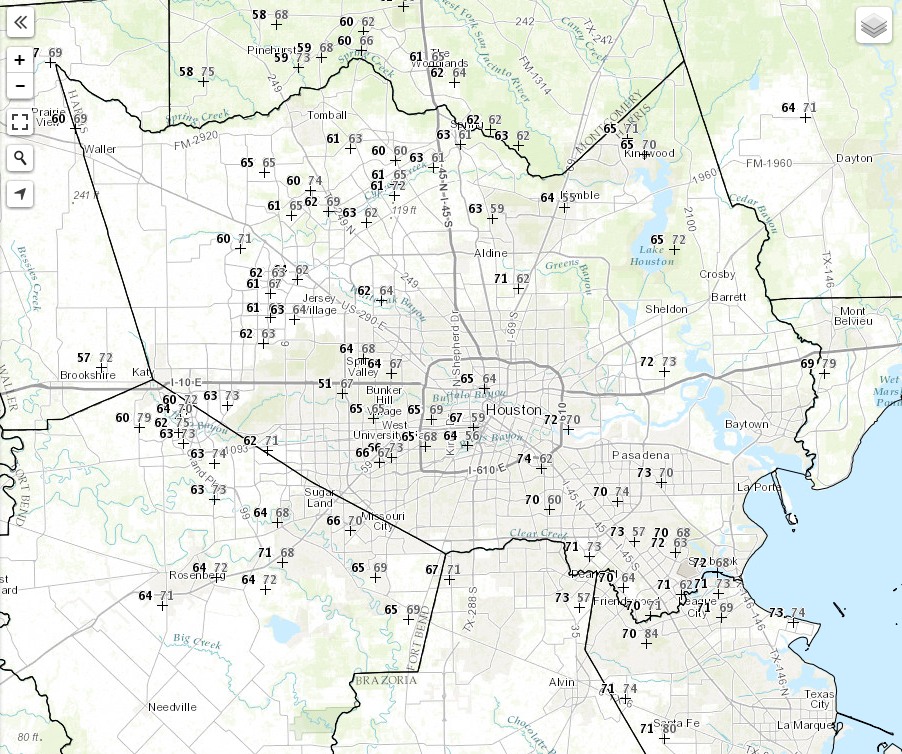
A cold front swept through Houston during the pre-dawn hours, bringing a few scattered showers. But mostly it was a dry front, heralded by a wind shift to the northwest. At Bush Intercontinental Airport the relative humidity dropped from 89 percent at 2:30am to 59 percent at 6am.
A cold front has knocked pre-dawn temperatures (black) into the 50s this morning. Gray numbers denote relative humidity. (NOAA)
So it will go for much of the region today, with highs in the mid-70s, much drier air, and breezy, northwesterly winds. Gusts could reach 25 or 30mph today before dying back tonight after sunset. Lows tonight should fall into the upper 40s for inland areas, and mid-50s along the coast.
Thursday and Friday
As I’ve been suggesting, the end of the work week will be spectacular for early April. Look for mostly sunny skies, highs in the upper 70s, and lows in the mid- to upper-50s.
The return of warmer air from the south, and mostly sunny skies today, should lead to quite warm temperatures. In fact, there’s at least a slight chance that Bush Intercontinental Airport will record a high of 90 degrees today—and that would be early, but not unprecedented. Houston’s earliest high temperature in a calendar year has come on Feb. 20 (1996), but a more normal time of year is the end of April, or early May. In this case, the heat won’t last long before we return to spring-like weather.
Today
Sunny conditions today, and very warm, before a mild night tonight in the mid-60s.
Wednesday
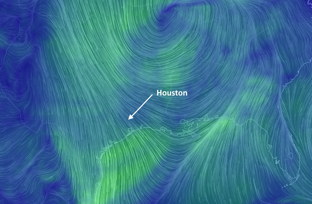
A cold front will move through Houston early on Wednesday, likely just before, or around sunrise. Despite the moisture return on Tuesday, there probably won’t be more than enough water in the atmosphere to squeeze out a few light, scattered showers. Certainly nothing to be concerned about. Skies should clear out after the front’s passage, and the bigger issue later on Wednesday will be winds, gusting out of the north-northwest at about 20 to 25 mph for most of the day. Winds will die down around sunset, and overnight temperatures will cool down into the low- to mid-50s for most of Houston except for the coast.
Brisk, northwesterly winds bring a taste of spring back into the Houston area on Wednesday. (earth.nullschool.net)
We’re looking at two gorgeous days across the Houston region, with highs generally in the mid- to upper 70s, and lows in the mid- to upper-50s. Ample sunshine. Hard—very hard—to beat the weather to end this week. Summer may be coming to Houston, but for now enjoy spring!
Saturday, Sunday, and beyond
We’ll remain mostly sunny this weekend, with highs of around 80 degrees. Lows are going to creep back up, however, with the return of moisture from the Gulf and rising humidity levels. By Sunday night into Monday morning, I think we’ll again see lows only touching about 70 degrees.
The forecast is cloudy for next week—probably the oldest meteorology joke right there, folks—as the potential returns for rain next week. But it’s not clear how much rain comes in. The European model is pretty aggressive, bringing 1-3 inches of rain during the first part of next week, while other models are less wet. Not something to be too concerned about at this time.
Good morning everyone. After a fairly stormy period for the region (not counting Sunday, which yes, was a lousy forecast for much of the area), the Houston region will enjoy some really nice April weather later this week after a front that “sticks.”
Today
The large storm system that raked east Texas and western Louisiana on Sunday has moved on to Alabama, Mississippi, and the toe of the Louisiana boot. In its wake Houston will see clear skies today, and the short-lived effects of Sunday’s cool front (this morning, basically) will give way to a warm day in the mid-80s. Lows tonight will only fall into the low- to mid-60s.
Tuesday
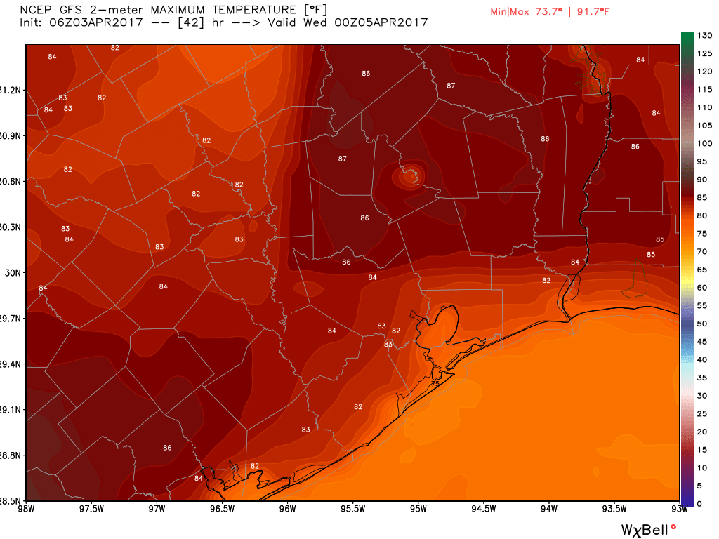
Another warm day that may test some high temperature records across the region. I’m looking for highs in the mid- to upper-80s with lots of sunshine for Houston. Look for some gusty southerly winds during the daytime as the onshore flow really gets moving.
Tuesday will be a warm one across the Houston region. (Weather Bell)
Wednesday
A cold front appears set to push into Houston late Tuesday night or early Wednesday—and right now I’d peg the timing at around sunrise Wednesday. Although there will be a bit of moisture to work with, the frontal passage will probably be dry for most people.
On Saturday evening Matt and I exchanged several e-mails discussing the possibility of storms today. We were concerned about the ongoing forecast, given that a number of forecast models weren’t showing much support for widespread severe weather in Houston on Sunday. This was largely due to the potential for the atmosphere over Houston to remain capped, which seemed like a distinct possibility based upon some of the available data. At the same time, other variables indicated the likelihood of an active weather day, and the National Weather Service and NOAA were continuing to forecast Houston under a “moderate” risk for severe weather, including the potential for tornadoes. So we were left with a dilemma—should we be an outlier and call attention to the possibility of a bust?
We decided not to, both because we still thought there was a decent threat of severe weather, and we didn’t want to offer a conflicting message to that from the official forecast warning offices, whose work we respect and trust.
Probably how you’re feeling right now
Understandably, if you live in Harris County or closer to the coast, you’re probably wondering where the tornadoes are, not to mention the rain. Probably half of the region didn’t see more than a sprinkle on Sunday. Some people canceled plans for today, based upon forecasts for severe weather. That is how it goes sometimes, and we are the first to acknowledge that we will make mistakes, as we did Friday, Saturday and Sunday with regard to storms in Houston today. What we want readers to understand is that our mistake was made out of imperfect information, rather than a desire to cause unnecessary alarm. (It is also worth noting that some very severe weather developed north, and northeast of Houston today, it just happened to be about 100 miles, or more, away from central Houston).
Why should you believe us? Our web site has no advertising. We have a sponsor, and we have sold out sponsorships for the rest of the year. There is literally no incentive for us to push the threat of severe weather for clicks, page views, or ratings. We have support for the site regardless. If our credibility is our most valuable asset—and we believe it is—then we actually have a strong disincentive to hype weather.
In any case, we’ll continue to do the best we can for you. Happily, after some lingering showers clear the area this afternoon, Houston is going to have some pretty darn nice weather this week. We’ll have full details on that in the morning.