Round one over, but more storms move into Houston this afternoon

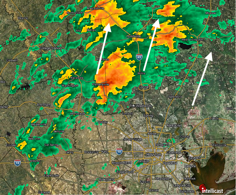
Northern parts of the Houston region experienced some pretty gnarly weather this morning, with damaging winds, reports of dime- and quarter-sized hail near Conroe, and rainfall rates in excess of 2 inches per hour. The radar also indicated the formation of some tornadoes, but they were not confirmed by ground observations. However those storms, associated with a warm front, have now moved out of the greater Houston region. Conditions should be mostly calm area wide for the next couple of hours.

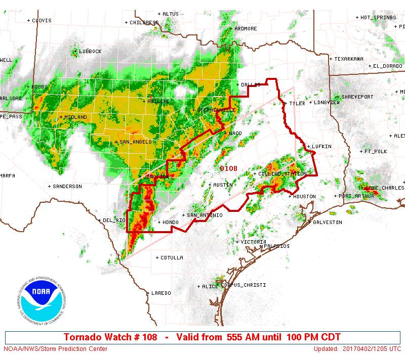
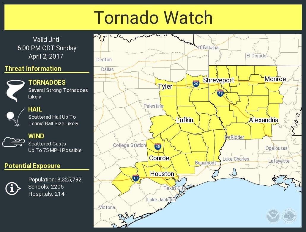
With that said, a large squall line of storms now east of Interstate 35 will move toward Houston this afternoon, likely reaching the region during the 1pm to 4pm CT time frame. Because of the moist, unstable air mass, the National Weather Service has issued a tornado watch from 1pm to 6pm for the entire metro area along, and north of Interstate 10.

Area of tornado watch in effect Sunday. (National Weather Service)

Why are we not as concerned about the southern half of Houston? Based upon the movement of storms in central Texas, it appears that most of the severe weather will occur over the northern half of the metro area. It is not entirely clear to me how much rain will fall south of Interstate 10, or whether it will just be mostly windy with dark clouds.

In summary

Matt has put together the following graphic to help understand the various elements we’re watching this morning, and into the afternoon hours (click to enlarge).

Areas of interest as of 11am CT. (Matt Lanza)

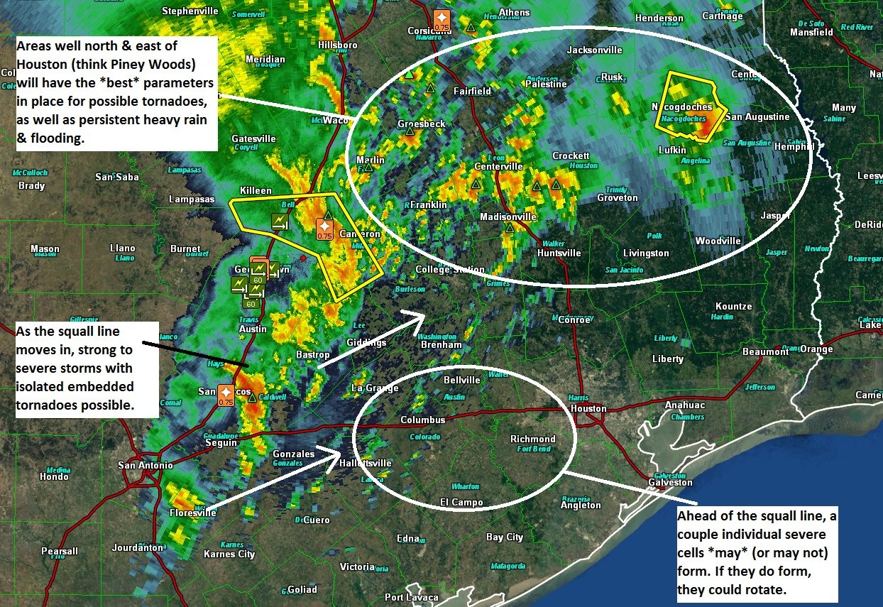
The bottom line is this: We’re most concerned about the threat of tornadoes north of Houston, but we can’t rule them out in Harris County. The heaviest rain this afternoon is also likely to occur north if I-10, but we can’t be sure how the storms will evolve as the move east from central Texas into the Houston region—will they strengthen, or weaken; and will they redevelop closer the coast?

Posted at 11am CT on Sunday by Eric

(Space City Weather is sponsored this month by The Mole, a Jonathon Price novel.)

Stormy day on tap for Houston, especially north of the city

Good morning. It’s going to be a stormy day for parts of the metro region, so let’s get right to it.

This morning

A number of showers and thunderstorms have developed along a warm front that’s moved in from the coast, and this will serve as a focus of showers and thunderstorms during the morning hours for the Houston area. These storms are developing primarily to the north of Interstate 10 (along the warm front) and bringing some heavy rainfall and severe weather to Waller and Montgomery counties, and points north.

Houston radar as of 7:10am CT showing storms north of I-10. (Intellicast)

The biggest concern is instability and rotation in the atmosphere, which is favorable for the development of tornadoes. Several tornado warnings have already been issued this morning—and a tornado watch is in effect through 1pm for the northern half of the Houston metro area, as well as much of central Texas.

Area of tornado watch in effect until 1pm CT. (National Weather Service)

It is possible that most areas south of, and along Interstate 10 don’t see much rainfall this morning.

This afternoon

Meanwhile, a large cluster of storms has developed across west Texas and is now (6:55am CT) moving eastward toward Interstate 35. These storms have formed along a cold front, and this mess will move into the Houston area this afternoon. Again, it seems likely the dynamics for severe weather and heavy rains will be most favorable north of Interstate 10 later today, but we’re going to have to watch the evolution of the system closely.

We’ll update again later this morning.

Posted at 7:05am CT on Sunday by Eric

(Space City Weather is sponsored this month by The Mole, a Jonathon Price novel.)

Severe weather is likely on Sunday in or near Houston

We’ve been tracking the possibility of heavy rain and severe storms on Sunday for several days now, and unfortunately the forecast remains on target. If anything, the outlook is worse for Sunday than it’s been.

NOAA’s Storm Prediction Center issued an updated “severe weather outlook” for Sunday, and the entire Houston metro area now lies under a “moderate” risk, the fourth highest category out of five. According to Jeff Lindner, a meteorologist with the Harris County Flood Control District, the severe storm warning level has not been that high for Houston since February, 2008.

Severe weather outlook for Sunday in Houston. (NOAA)

A combination of a potent upper level storm system, moisture moving in from the Gulf of Mexico, and the potential for supercell development will set the stage for storms on Sunday, some of which may become severe.

(Space City Weather is sponsored this month by The Mole, a Jonathon Price novel.)

Forecast models still aren’t in agreement about whether chances for severe storms will begin around sunrise on Sunday, or hold off until the early afternoon hours for most of the Houston area. There also remains some uncertainty about whether the best setup will occur over Houston, or to the northwest of the metro area, between Austin and Lufkin. But tomorrow will definitely be a day to pay attention to forecasts (we’ll be covering), real-time conditions, and official warnings issued by the National Weather Service. We’re concerned about tornadoes—some of which may be more severe than the EF-0 and EF-1 the Houston area typically gets—large hail, and damaging winds.

Heavy rainfall is also a secondary threat, with most of the area likely picking up between 1 and 3 inches, and higher isolated amounts. In short—a mess.

Posted at 9:15am CT on Saturday by Eric