Harris County Judge releases 15-point plan to address Houston flooding

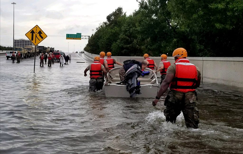
Nearly two months have passed since Hurricane Harvey drowned the upper Texas coast. There have been numerous public hearings, state meetings, and some squabbling about who should pay for cleanup, reconstruction, and mitigation.

But for the first time, this week, Harris County Judge Ed Emmett stepped forward with some concrete ideas about how the make future flooding events like Harvey less worse. “Now is not the time for a piecemeal approach,” he said Wednesday, during a news conference, in which he released a 15-point plan. “The sense of urgency created by Harvey will fade, so we must quickly commit ourselves to a comprehensive plan to redefine Harris County and the surrounding region as a global model for living and working in a flood-prone area.”

Texas Army National Guard soldiers move through flooded Houston on Monday, August 28. (US Army photo)

We have included each of Emmett’s 15 proposals below to spur the community discussion. There are a lot of good ideas here. One of the things that makes the most sense, from our perspective, is the creation of a regional floodwater management organization that would consist of representatives from area cities, counties, and other government organizations. Such a body could take a holistic approach to flooding, which is truly a regional problem, identify problems, find solutions, and then present them with a unified voice from the greater Houston community.

The biggest problem is that enacting a lot of these ideas will require cooperation between city, county, state, and federal officials. The political environment for such cooperation seems poor at this time, but Emmett is correct that if the region does not act now, Harvey will fade into memory and Houston will remain as vulnerable as ever to flooding. Ultimately, making a lot of these changes will require pressure from citizens, civic organizations, non-profits, and those who take the long view that Houston should be a great, livable city for decades and centuries to come.

See full post

Houston warms briefly before a very cold October weekend

Some warmth returns to Houston briefly on Thursday before a cool front sweeps into the region on Friday, bringing the coldest weather since February. While the greater Houston area is unlikely to freeze, inland areas have a decent chance of seeing overnight lows on Saturday and Sunday morning fall into the 30s. Let us hope the Dodgers’ bats go as cold this weekend.

Thursday

As a southerly flow resumes this morning, humidity will return to Houston, and highs will climb into the lower 80s under sunny skies. There could be some gusty southerly winds later this morning, especially closer to the coast. Lows tonight will be in the 60s.

GFS model shows front moving through most of Houston by noon, Friday. (Weather Bell)

Friday

A strong cold front will approach the northwestern areas of Houston on Friday morning, likely pushing into the city around 9 or 10 am (give or take), and off the coast by or before noon. Some scattered showers and thunderstorms may accompany the frontal passage, but we’re not expecting any kind of significant rain accumulations, and rains should end during the afternoon hours. Highs should reach around 70 degrees on Friday before a steep dropoff in temperatures during the evening hours.

See full post

Houston may reach record lows on Sunday morning

The record low temperature for October 29th in Houston is 39 degrees—and there’s a chance we just might beat that on Sunday morning. Yes, the air mass moving into the region this weekend looks just that cold. And after a chilly weekend, temperatures should rebound for pleasant conditions on Halloween.

Wednesday

After a cool start to Wednesday, with much of Houston in the mid- to upper-40s this morning, we’re going to have absolutely splendid weather with highs in the upper 70s across the region. Look for another pleasantly chilly night, with lows in the upper 40s inland, and 50s for the southern half of the region.

Thursday

Gulf moisture returns Thursday, setting the stage for a bit of a warmer day with a high in the low 80s, under sunny skies. Overnight lows will only fall into the lower 60s. But then, yet another front will move into the area on Friday.

Friday

With just enough moisture moving onshore Thursday, a front moving through the area on Friday morning will bring a chance of scattered showers during the morning and afternoon hours. None of the models are overly bullish on rain chances, and people that do see rain probably will see a tenth or two.

Rainfall accumulation forecast for Friday during and after the front’s passage. (National Weather Service)

Conditions will clear later in the day under breezy northerly winds. Lows Friday night will fall into the mid-40s for central Houston, with colder conditions north, and warmer toward the coast.

See full post

Get ready for Houston’s coldest weather since February

It’s a bit warmer this morning, with lows only falling into the lower 60s for most of Houston. But the air is also pleasantly dry, with relative humidity levels around 50 to 60 percent across most of the area when, during more muggy times, they would be closer to 100 percent. A reinforcing cool front will keep things on the dry side for Houston.

Tuesday

A cool front will move through the region today, increasing wind speeds this afternoon into the teens, with gusts up to around 20 mph. With the air so dry, there is virtually no chance of rain. Highs should reach the low- to mid-70s under mostly sunny skies.

The image of cloud top heights shows a low pressure system over the Midwest pushing a front through Texas this morning. (NOAA)

With the front’s arrival and influx of drier air, temperatures will fall pretty quickly after sunset, and inland areas should see lows in the 40s, while central and southern parts of the metro area are around 50 degrees or a bit warmer. While Los Angeles swelters under the heat of the Astros bats (and 100 degree temperatures this evening), Houston will be enjoying fine, fine weather.

Wednesday

A splendid day. Highs in the mid-70s. Sunny. Low winds. Another cool night.

See full post