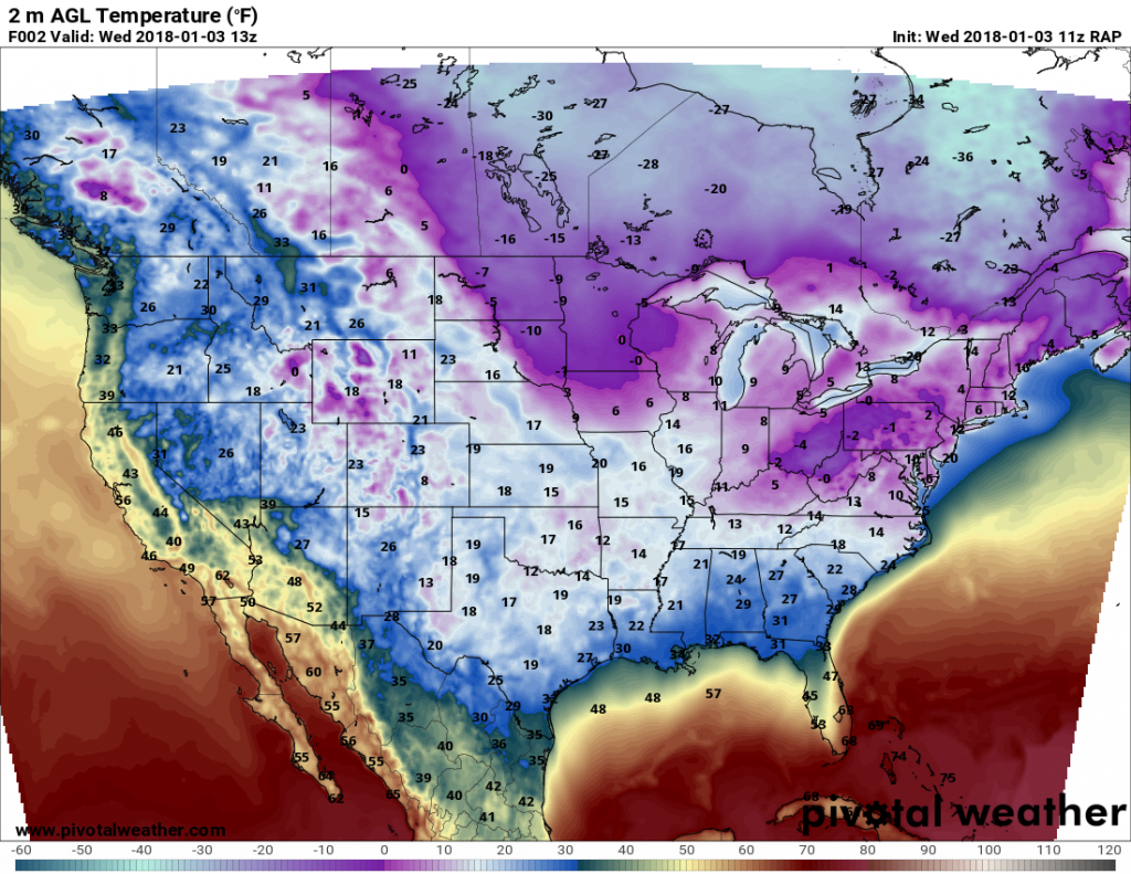
Houston saw some scattered light snow and sleet on Tuesday evening, but drier air at low levels of the atmosphere prevented more widespread coverage. After this system moved out of the area, skies began to clear from west to east across the region after midnight and this allowed for very cold temperatures to settle into southeast Texas. As of 6:30am CT, lows range from about 20 degrees in College Station, to 25 in the city of Houston, to 30 degrees in Galveston. Up north, this is nothing. But for Houston, this is very cold—with many sites tying or breaking record low temperatures for January 3. If you’re tired of this, there’s good news. We’ve seen the worst of it now.
When you look at forecast low temperatures for Wednesday morning, suddenly the mid-20s doesn’t seem all that bad. (Pivotal Weather)
Wednesday through Friday
One big thing happens today: full sunshine returns to Houston. It’s been awhile. But the next three days should see nearly continuous sunshine during the daytime hours. This will allow for a sloooow warming trend, from highs today in the low 40s to the low 50s by Friday. Overnight lows, too, should climb from around 30 degrees Wednesday night to about 40 degrees by Friday night.
This has been a rocking winter for H-town if you like snow or sleet. We had some surprise sleet across much of the area this morning, and if what we’re seeing is correct, we’ll be talking about some more surprise sleet or even snow this evening.
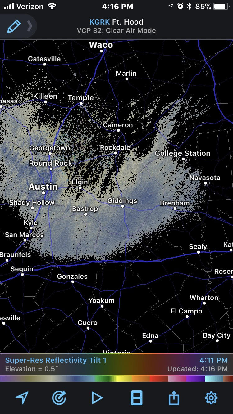
As of 4:15 PM Tuesday, some light snow is showing up on radar between Houston and Austin. Though that is likely not yet reaching the ground, as it slides east and organizes a bit more, we could see that change.
Radar as of 4:15 shows light snow falling (though likely not reaching the ground just yet) between Houston and Austin. (Radarscope)
All of this is being driven by a pretty potent little disturbance a few thousand feet up that will help deliver snow or sleet to Florida and Georgia tomorrow and eventually New England on Thursday. That slides into Houston after 9-10 PM or so tonight.
I’ve been watching the HRRR model literally all day today, and with each run it has boosted or maintained its depiction of what happens over Houston as the disturbance exits tonight. The HRRR is a really short-term weather model that we use in the 0-18 hour timeframe for forecasting. By no means is it perfect, but it’s been tough to ignore the trend it has shown today, somewhat corroborated by some other modeling this afternoon.
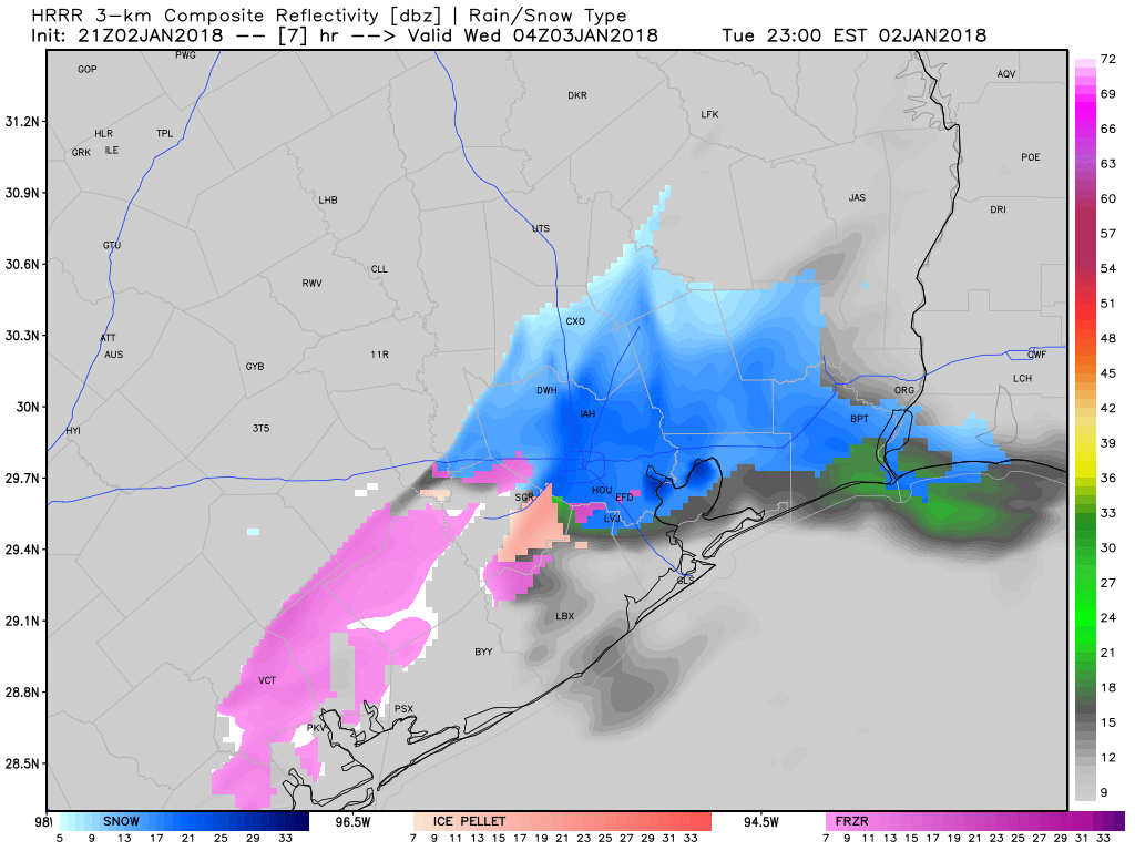
Here’s a forecasted radar depiction from the HRRR model this evening at 10 PM.
The HRRR model indicates some snowflakes or a mix of snow and sleet (ice pellets) this evening across Houston, especially east of I-45. (Weather Bell)
This shows a quick burst of snow or mixed snow/sleet as it moves through. The prime time for this to occur would be 7 PM-1 AM. After that, it will move offshore and skies will clear out allowing temperatures to plummet.
So what to expect?
A brief (1-4 hour) burst of snow or sleet this evening is possible.
Snow or sleet could actually come down at a healthy clip for a short time in a few places.
Any accumulations would be minor and probably not cause severe problems for travel, but (there’s always a but) just keep in mind that this may occur tonight if you have to be on the roads after, say, 8 PM and drive with extra care just to be safe.
With cold temperatures in place and several days of cold built up, if it were to snow a little heavier than expected, it could lead to a dusting on roads (similar to what we saw southeast of Houston this morning from the sleet).
Any snow or sleet ends from northwest to southeast from 11 PM to 2 AM, with clearing overnight, followed by bitter cold overnight and Wednesday morning low temps in the Houston metro area. A hard freeze is likely over most of the metro area tonight.
Please share any of your observations tonight with us here, Facebook, or via Eric or Matt’s Twitter feeds!
Hello fellow marathon runners and volunteers. In 12 days, it will be all over but the recovery. And now that the big training runs are over, all that we can do is trust our preparation, and hope for good—cold—weather on the big day. To that end, for the rest of this week, I’ll be providing afternoon updates on what we can expect for Sunday, Jan. 14th.
Of course any weather forecast beyond about seven days out is going to have a lot of uncertainty, and anything beyond 10 days is even more problematic. But that does not mean such forecasts have zero value. The best way to look at weather this far out is to study the ensemble forecasts of the main global models. These are the 50 or so lower resolution runs of a given model, with slightly different initial conditions. By looking at the spread in output from these models, we can gauge the probability of cold, normal, or warm weather for 12 days from now. Looking at the 12z runs of the European and North American models, here’s what I have for you.
Starting with the European model I have broken down the possibilities for start line temperatures into four different categories:
Warm: 3 degrees F or more warmer than normal
Normal: +3 to -3 degrees within normal (average high is 65, low is 47 degrees)
Cold: -3 to -10 degrees below normal
Very cold: -10 degrees or more below normal
In looking at each individual ensemble member of the European model, here are the Houston temperature anomaly outputs sorted by category:
Warm: 5
Normal: 4
Cold: 33
Very cold: 8
Too obtain probabilities, just multiply those numbers by two. So, roughly, according to the European model this afternoon, there is a 20 percent chance of warm or near-normal weather for the marathon, and an 80 percent chance of cold or very cold weather.
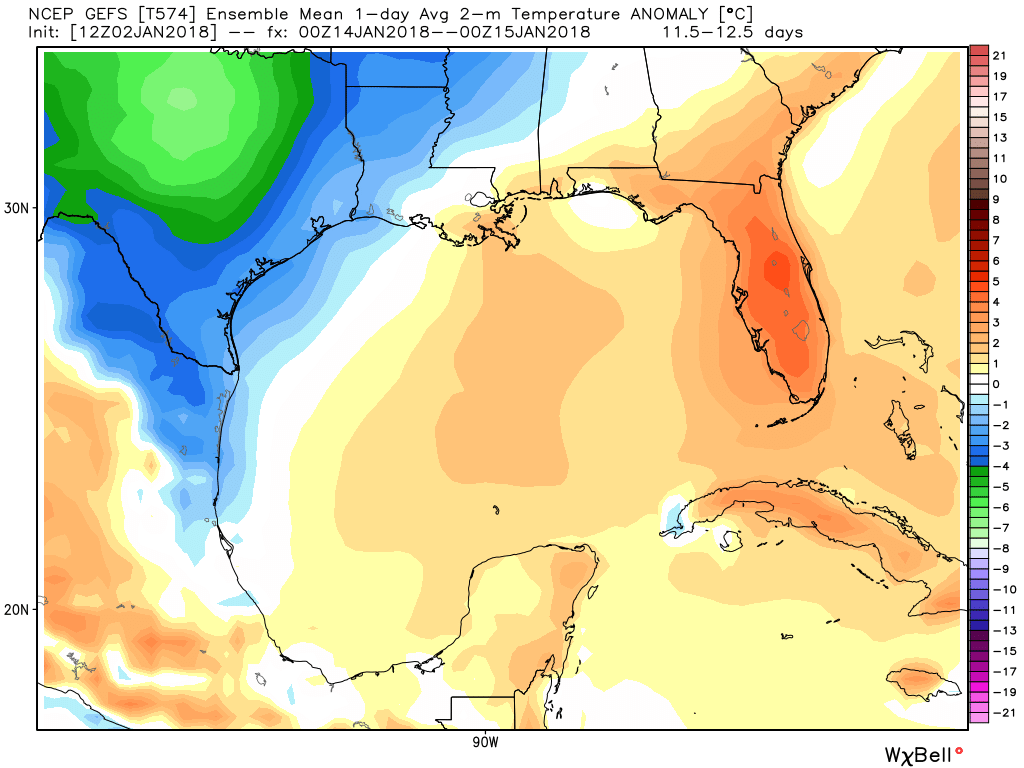
Looking at the GFS model, the we can see the mean of the ensemble members for January 14th is about 2 Celsius degrees (4 degrees Fahrenheit) below normal. But this model isn’t as cold as the European model.
Average temperature anomaly produced by the GFS ensemble members. (Weather Bell)
This is a much better forecast for the 2018 run than what we saw in 2017 (warm and very humid), but it is far from locked in. There are also some concerns.
The models are suggesting that some kind of fairly strong cold front moves through the region toward the end of next week, and this could bring with it some decent precipitation. If that front is late, we could still be warm for the marathon. Or the front could drag through on a Friday or Saturday, leaving behind some cold rain for the marathon itself. That, obviously, wouldn’t be ideal either. All that said, I’d still rather be looking at probable cold weather more than just about anything.
It’s cold—but not extremely cold—across the Houston region this morning. Although wind chill temperatures are in the teens, the mercury has generally remained in the upper 20s for most of Houston during the overnight hours due to persistent cloud cover that has helped the surface retain some of its heat. That should change Tuesday night, with clearer skies allowing for colder overnight temperatures.
Tuesday
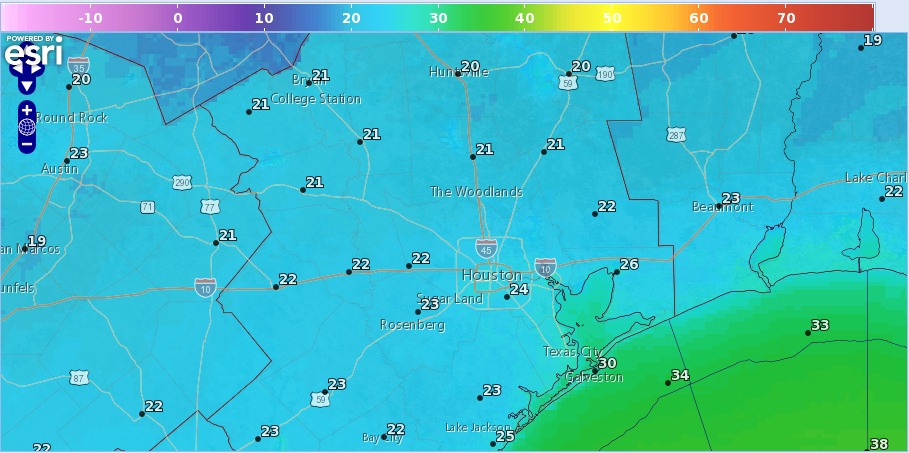
On New Year’s Day, the high of just 41 degrees gave Houston its coldest daytime temperature since Jan. 10, 2015. We’ll probably be colder today as skies remain partly to mostly cloudy for Houston, and limit highs to the upper 30s. For coastal areas, there is also a slight chance of sleet today, but we aren’t worried about any kind of freezing precipitation accumulation. For one, much of the sleet is likely to evaporate before reaching the ground. And secondly, temperatures along the coast will be sufficiently above freezing today.
Low temperature forecast for Tuesday night. (National Weather Service)
As skies clear across the region tonight we’ll see ideal weather for radiational cooling, and this is when we expect to see very cold overnight lows ranging from about 20 degrees for far inland areas to 30 degrees along the coast. Houston’s record low temperatures for January 3rd is 25 degrees, and I believe we will definitely threaten that at Bush Intercontinental Airport.