Weekend forecast coming into better focus for Houston

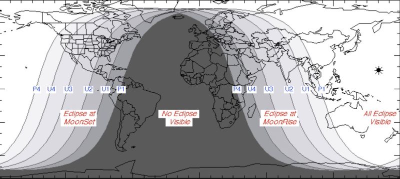
Clear skies have allowed temperatures to cool down this morning, and more importantly they’ve afforded most of the region a good view of the total lunar eclipse. The Earth passed between the Sun and Moon just as the Moon set, and Sun rose over southeast Texas on Wednesday morning.

Wednesday

Southerly winds have returned to Houston, and this will allow temperatures to climb today to about 70 degrees under partly to mostly sunny skies. All in all, it should be a fairly pleasant day for the region, with temperatures tonight 10 to 15 degrees warmer than Tuesday night.

Thursday

Thursday will be even warmer, with highs in the mid-70s as southerly winds draw in warmth to the region. Some scattered, light showers are possible during the afternoon, evening, and overnight hours as a cool front approaches the area, and moves through. It should be off the coast before sunrise on Friday.

Thursday will be one of the warmest days of the winter in Houston. (Pivotal Weather)

Friday

A much cooler day, with mostly cloudy skies and highs generally in the upper 50s. Winds will be out of the north, but I don’t think they’ll be too gusty like they are after some cold fronts we get. Lows Friday night should fall into the 40s for most of the region.

See full post

Mostly clear weather for Wednesday’s total lunar eclipse

Houston is seeing temperatures this morning that range from the mid-30s inland to the upper 40s along the coast. This will probably be the region’s coldest night for about a week or so, and at this point another freeze seems unlikely for the next 10 days.

Tuesday

The region will see quintessential winter weather, with highs of around 60 degrees under full sunshine. Lows Tuesday night and Wednesday morning will probably be about 5 degrees warmer than Tuesday morning and, importantly, skies should be mostly clear.

Lunar eclipse

Clear skies are important because of the opportunity to see a total lunar eclipse shortly before the Moon sets. For Houston, the totality begins at 6:51 am but the partial eclipse begins about an hour before that, so plan to get up a little early tomorrow to see a neat celestial sight. You’ll want a jacket.

Texas will see a total lunar eclipse on Wednesday morning as the Sun rises, and Moon sets. (Fred Espenak)

Wednesday

Southerly winds will return sometime on Tuesday, and that will allow for the return of scattered clouds on Wednesday, and nudge temperatures into the upper 60s. We should also see a much more mild night, with lows only in the 50s across the area.

See full post

Sunny to start the week in Houston, with an uncertain weekend

Houston had less than an ideal weekend, with storms Friday night and into Saturday morning, a gray day Saturday, and with skies only beginning to clear on Sunday afternoon. I’m sorry to say that next weekend doesn’t look ideal for outdoor activities either—although I wouldn’t bet on a total washout just yet.

Monday

It’s chilly out this morning, with lows ranging from the upper 30s up north to around 50 degrees right along the coast. A reinforcing cold front will move into Houston today, likely before noon, and along with this we’ll see noticeably stronger northerly winds. This will bring drier, cooler air into the region. Expect highs in the mid-60s and sunny skies, with overnight lows tonight in the upper 30s to lower 40s for most of the Houston region. A freeze is possible for far northern Houston.

Tuesday morning will probably be the coldest one of the week. (National Weather Service)

Tuesday

A cool winter day with a high only of about 60 degrees under sunny skies. Overnight lows Tuesday night will be a few degrees warmer than Monday as winds shift from the northeast to the southeast.

Wednesday

A pretty nice day. Moisture levels begin to return, but we’ll still see mostly sunny skies, and highs should climb to about 70 degrees for most of the area.

See full post

Weekend weather and another look back at Hurricane Harvey

A lot of stuff to get to today. We’ll go through the forecast first, and then jump into the National Hurricane Center’s final report on Hurricane Harvey, released yesterday.

Today & Saturday

We’re thinking today will be a rather uneventful weather day. We should see a good deal of cloud cover around, with limited (if any) sunshine. Temperatures are starting the day much warmer (around 50° in most spots, roughly 15° milder than yesterday at this time), and they’ll likely finish warmer than yesterday too. We should manage about mid-60s this afternoon.

In terms of rain, the bulk of today should be dry, but there could be some sprinkles or showers.

Things do change tonight as onshore flow continues, driving in ample moisture. A weak disturbance passes offshore, and this combination will lead to increasing rain chances as the night goes on. The best chance for the most shower activity will be south and east of US-59. The general rule of thumb will be that the closer to the coast you get, the better rain chances will be. Saturday will see shower chances continue in the region, but I think they’ll be highest both in the early morning and later afternoon. And once again, they’ll be highest south and east of Houston. Still, have an umbrella handy Saturday. It will be warm again, with highs near 70 degrees.

Total rainfall tonight and tomorrow will be highest well south and east of Houston. (Weather Bell/WPC)

Generally, we’re only expecting about a half inch or less in and around Houston. Some coastal locations could see upwards of three-quarters of an inch or so of rain. Higher amounts will be possible as you move toward Beaumont-Port Arthur and Lake Charles. Also, watch for some patchy dense fog along the coast (or even in some inland spots) later today through Saturday night.

Sunday into next week

A cold front will pass through the area Saturday night without much punch. You’ll notice it more Sunday with lowering humidity and gradually decreasing clouds. Expect temperatures to top off near 65° or so on Sunday. Sunday night will be chilly, with lows back into the 40s in the area. Monday and Tuesday continue to look splendid, with highs in the low-60s and lows in the 40s. We’ll see a warm up with increasing clouds and minor rain chances after Wednesday.

See full post