After a prolonged period of wet weather, the Houston region will see a moderate reprieve as we break from a pattern of widespread, daily rainfall. (Showers aren’t going away entirely, however). It is during this break that we will look for the region’s first real fall cold front. We’re overdue, now—way overdue. As you may recall, we’ve made the arbitrary decision to define this front as the first night after September 1 with an overnight low temperature of 65 degrees or lower at Bush Intercontinental Airport.
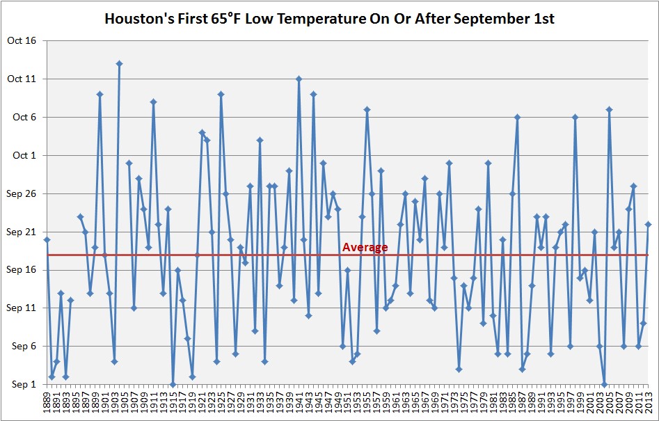
The average date for this first front is Sept. 18—two weeks ago—but there is a wide range of variability. For example, it is not unheard of for the first front to arrive in October. It happens about once every 10 years, on average. However, it is rare to get too deep into October without a cold front, and the latest Houston has waited since at least 1889 is October 13th. I’m afraid we’re in danger of setting this record this year.
Per the ensembles of the GFS and European forecast models, the region’s first cold front is unlikely to arrive in Houston this year any time before a time period between Oct. 11 and Oct. 15—nine or 10 days from now. Ughhhhhh.
Tuesday and Wednesday
As higher pressures move into the region, our weather pattern will turn moderately warmer, with high temperatures likely in the upper 80s. Temperatures will ultimately depend upon the amount of sunshine this afternoon, as we expect partly sunny skies. Rain chances will fall back into the 30 percent range, with showers most likely during the late morning and afternoon hours along with daytime heating. Lows in the mid-70s.