After a prolonged period of wet weather, the Houston region will see a moderate reprieve as we break from a pattern of widespread, daily rainfall. (Showers aren’t going away entirely, however). It is during this break that we will look for the region’s first real fall cold front. We’re overdue, now—way overdue. As you may recall, we’ve made the arbitrary decision to define this front as the first night after September 1 with an overnight low temperature of 65 degrees or lower at Bush Intercontinental Airport.
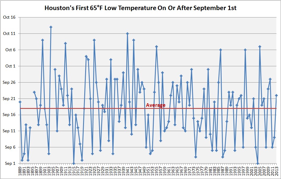
The average date for this first front is Sept. 18—two weeks ago—but there is a wide range of variability. For example, it is not unheard of for the first front to arrive in October. It happens about once every 10 years, on average. However, it is rare to get too deep into October without a cold front, and the latest Houston has waited since at least 1889 is October 13th. I’m afraid we’re in danger of setting this record this year.
Per the ensembles of the GFS and European forecast models, the region’s first cold front is unlikely to arrive in Houston this year any time before a time period between Oct. 11 and Oct. 15—nine or 10 days from now. Ughhhhhh.
Tuesday and Wednesday
As higher pressures move into the region, our weather pattern will turn moderately warmer, with high temperatures likely in the upper 80s. Temperatures will ultimately depend upon the amount of sunshine this afternoon, as we expect partly sunny skies. Rain chances will fall back into the 30 percent range, with showers most likely during the late morning and afternoon hours along with daytime heating. Lows in the mid-70s.

Thursday and Friday
The pattern more or less continues, although as the influence of high pressure backs off, we may see slightly more rain coverage toward the end of the work week. There’s still no signal for heavy rainfall, so the 40 to 50 percent of the region that does see rain will likely only see tenths of an inch, rather than inches. Highs, again, should be in the mid-80s, with lows in the mid-70s.
Saturday, Sunday, and early next week
With no real fronts on the horizon to clear out this muggy weather, for now we expect it to carry into the weekend and early next week. We expect a healthy chance of rain, especially on Sunday and Monday, but for now there’s nothing to indicate anything too extreme. We’ll try to have a more dialed in weekend forecast tomorrow, but for now there’s not a whole lot of clarity beyond these generalities.
In terms of rainfall, overall, the region may see between 0.5 and 1.0 inch of rain through next Monday, with higher localized totals.
Hello Eric!
Thank you for the update! What are your thoughts regarding the possible tropical development in the Caribbean and its impacts to our area? National Hurricane Center is giving it 20% at this point. We are supposed to be leaving in October 14th for 2 weeks and I am getting nervous about leaving due to possibility of tropical development. Usually by middle of October I start feeling much better about tropics, but this year seems to be different. Thank you so much!
No threat, get pulled north and east if it develops at all.
What Jason said.
LOL
The GFS model has it going into the Gulf and toward our part of the Gulf. How reliable is this prediction? Thank you!
I saw this on our local 8 pm weather as well..Euro taking system to Florida, GFS taking it closer to us..
Everything is unreliable with such a disorganized system. I would have very low concerns right now.
It seems the warm weather started early this year as well. How does the date of the last sub-65 night this spring compared to normal? Is this our longest “summer“?
As someone who grew up in Montana, I will gladly take some late summer heat over early snow, which is already showing up on the Glacier park webcams and forecasted to hit the Colorado rockies.
I know I saw on weather channel snowing in Billings on Sunday! Just seems crazy for this early in the year. Houston is basically Hawaii compared to some of those places.
What’s the rush? It’s been damp but pleasant temps for the past month, and beats snow any day!
Plenty of us sleep much better when it’s cool and crisp out
What was the total rainfall for Galveston in September? A record? I remember a week or so after Hurricane Harvey hit sitting on the deck watching our flooded river dump debris on our yard but having a respite with a cool breeze helping with our labors. Wish for the breeze now, not the flood.
From yesterday’s post: https://www.weather.gov/hgx/climate_gls_top10_sep
2018 was the second wettest Galveston September.
From yesterday’s post: https://www.weather.gov/hgx/climate_gls_top10_sep
2018 was second to 1885 for wettest Galveston September.
Does such a late fall start tell us anything about the weather pattern for the next few months?
I guess cold is a subjective thing, but 65 seems a tad on the warm side, especially for an overnight low, to call a “Cold Front”. I would say a max overnight of 45 would be a more adequate temperature to call a “Cold Front”
I’m going to need a machete to even get into my back yard before if it doesn’t stop raining on the weekends… I need just a couple of days for everything to dry please. Then it can rain again!