Well, we made it through the end of September. And a strange month it was. No tropical storms or hurricanes hit Texas, and yet it has been one of the wettest months in the state’s history. Much of the state received 200 to 400 percent normal levels of rainfall, including all coastal areas of the Houston region (Galveston will record its second wettest September ever, and third wettest month of all time).
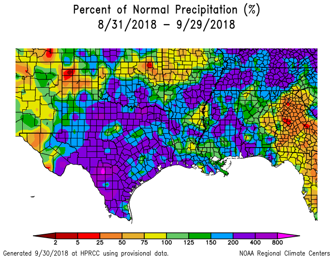
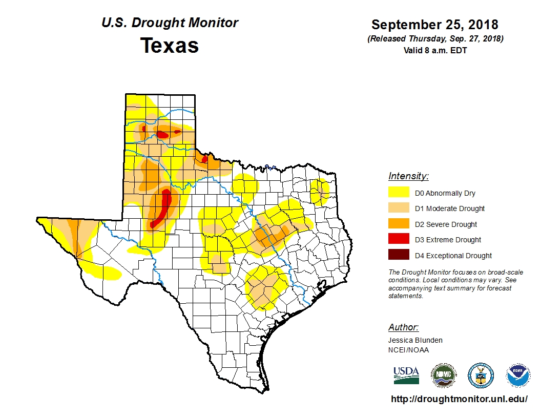
As a result, at the end of a summer in which no tropical storms or hurricanes moved into, or near Texas, the state finishes the hottest part of the year with just eight percent of the state in a “severe” or worse drought. This is a really healthy posture to be in, compared to typical years for Texas at the end of September.
That does not mean September has been particularly fun. Heavy rainfall during the last month has, on at least three occasions, brought significant flooding to Galveston Island and other coastal areas. For much of the region, nearly all of September was a soggy, humid mess with cloudy days and steamy nights. Speaking personally, I am not sorry to see it in the rear view mirror. Now, onto the forecast.

Monday
Unfortunately, October won’t start off all that much differently than September. The pattern today will be similar to this weekend, with showers and thunderstorms developing offshore during the pre-dawn hours and then moving inland during the daytime. Coverage Monday should be spottier than over the weekend, but isolated areas could still pick up a few inches of rainfall. Highs will be in the 80s, and will depend on the extent of cloud cover.
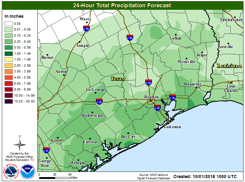
Fortunately the upper-level pattern, which has created favorable conditions at the surface for rainfall, is now moving away from the Houston region. This should drag the shower activity northward later today, out of the area, and set up somewhat drier conditions for the rest of the work week.
Tuesday, Wednesday, and Thursday
Higher pressure will move into Houston during the middle of this week, and this should help limit rainfall. We’ll still see a chance of showers each day, probably in the 30 percent range, but skies should be at least partly sunny. In areas where there’s more sunshine, we’ll see high temperatures push up toward 90 degrees, although I think most of the city probably will remain in the 80s. Nighttime temperatures, unfortunately, will remain in the muggy mid-70s.
Friday, Saturday, and Sunday
Well, we can say that next weekend won’t be as bad as this past weekend. But that doesn’t mean it will be a whole lot better, weather-wise. I’d guess rain chances will be a solid 40 percent over the weekend, with highs in the mid- to upper-80s with warm nights. There’s not a strong signal for heavy rainfall, and I think we’ll still see some partly sunny skies. But at this point I don’t have too much confidence in the weekend forecast.
As for our first real fall cold front, I’ll dig into that in more depth tomorrow. Right now, it’s still a ways off. (Sorry, I really do hate myself for writing that).
At least all the rain kept it cooler than a usual September. We’ll get a norther…one of these days!
The rain has at least provided cooler temps than usual for the time of year. The bright spot among a bunch of clouds.
I know prognostigating weather can be difficult, but is there one factor you can point to as to what caused all this rain for so long? Is it La Niña, El Niño, an upper level high, a surface low or a combination of things in the atmosphere? I mean, it was the same thing over and over and over, day after day after day. I can’t ever remember such a persistent weather pattern hanging on for so long in past years.
All this rain and odd weather really put a cramp on my sailing while im off the towboat. Please tell me that the next 10 days will bring sunny skies and high winds lol
It does seem like a solid cool front is taking its own sweet time getting here. Is this worrisome (i.e. further proof of climate change happening way more rapidly than we realize)?
Karen, I think one of the best answers to that is to look at pop culture references to the weather of the past to see what was considered “normal” back in the day.
In the semi-autobiographical “To Kill a Mockingbird,” Harper Lee wrote about a year in the 1930’s where they reached the end of October and it was still hardly cool enough for a light jacket. A year or two before, their Alabama town had experienced a record norther that brought snow for the first time in living memory. The southern US seems to be experiencing a similar range in variations of weather patterns today, so I don’t think those variations can be attributed to climate change at this point. If we’re suddenly breaking 100 in November or getting several feet of snow in Houston, that might point to something truly out of the ordinary.
…. what?
lol classic.. the best answers to scientific questions about today’s weather aren’t based in science!
Much better to look at an anecdote from a fictional book about one location 80 years ago.
Too many people confuse weather with climate. They are not one and the same. Even in terms of weather we don’t have ANY records to go on past a couple of hundred years ago. Science can reliably pinpoint CLIMATE for a short period (i.e.) a hundred years in the past, but NOT weather. That there IS climate change there is no doubt. There is ALSO no doubt that earth has been in a continual state of climate change forever. Literally. The question is if, and how much man contributes to the current change. That is not a question that has been answered, contrary to what the media reports. They are very good at HIDING the scientists who have reservations about man’s contributions. Few if ANY say man absolutely has nothing to do with it. But many, a vast majority say it is still a question. The media, and governments don’t want joe and jill sixpack to know that. I have serious reservations myself, but am dead set AGAINST moving back the steps that have bee taken in HOPES of combatting change. If it turns out man has nothing to do with climate change a cleaner planet for HUMANITY’S sake is worthwhile.
If you want Fall, move to Denver, or wait till December.
Well dang, if September had 31 days I would have won my $5 bet that here in Lake Jackson, southern Brazoria, we’d have a total of 22″. instead, only had 21.88″. That one extra day, today, would have put us well over 22″ as it’s been driving sheets of rain this a.m.
If it’s anything like the last couple years, then my guess is they will come at once or right behind one another, and will all be significantly strong fronts. The bad thing is that it’s hot until then, and it also leaves us unprotected from storms since the fronts sort of close the gates for tropical systems.
Remember that the average high right now of 85 is just that – an average, and does not necessarily mean our “normal” high is 85. It just means sometimes it’s 90, sometimes it’s 80, and other times somewhere in between.
Again – no cold front for you!!! Anyone know what the record is for latest cold front to hit Houston?
I guess it depends how you want to define cold front since some are really weak while others are very strong, but the latest date that Hobby Airport finally dropped below 60 degrees after summer was October 22 in 1956 (that is with data going back to 1948). September 23 – October 8 seems like the average window for a first dip below 60 for that part of Houston.
Eric or Matt, can you please give us the layman’s version of this: What will this mean for Houston?
Gulf of Mexico and Bay of Campeche – Although dry air and at least moderate shear would dampen tropical development, some models are showing that a low forming in the Caribbean might move northward into the Gulf of Mexico and intensify, sometime after the 8th.
Caribbean Sea – Models are hinting that a low could form in the western Caribbean later this week that may intensify to some degree from the 6th on.
Sure. There are signs that some sort of tropical activity is likely about a week or so from now in the northwestern Caribbean Sea, and this will likely move north into the Gulf. Nearly all of the modeling takes this weather toward Florida or the northern Gulf coast.
Did Cliff from Cheers post a few of these today?