First of two fronts this week arrives later today, thunderstorms possible

Good morning. Houston faces a round of scattered storms later today as a weak front moves into, and through the region. Another front arrives later on Friday to set the stage for a great spring weekend. As a reminder, we’ll be producing our second Weather Wednesday video tomorrow at 2pm CT, over on our Facebook page. More than 12,000 people watched the first video, so we’re gratified by your interest. Please submit any questions you have below.

Tuesday

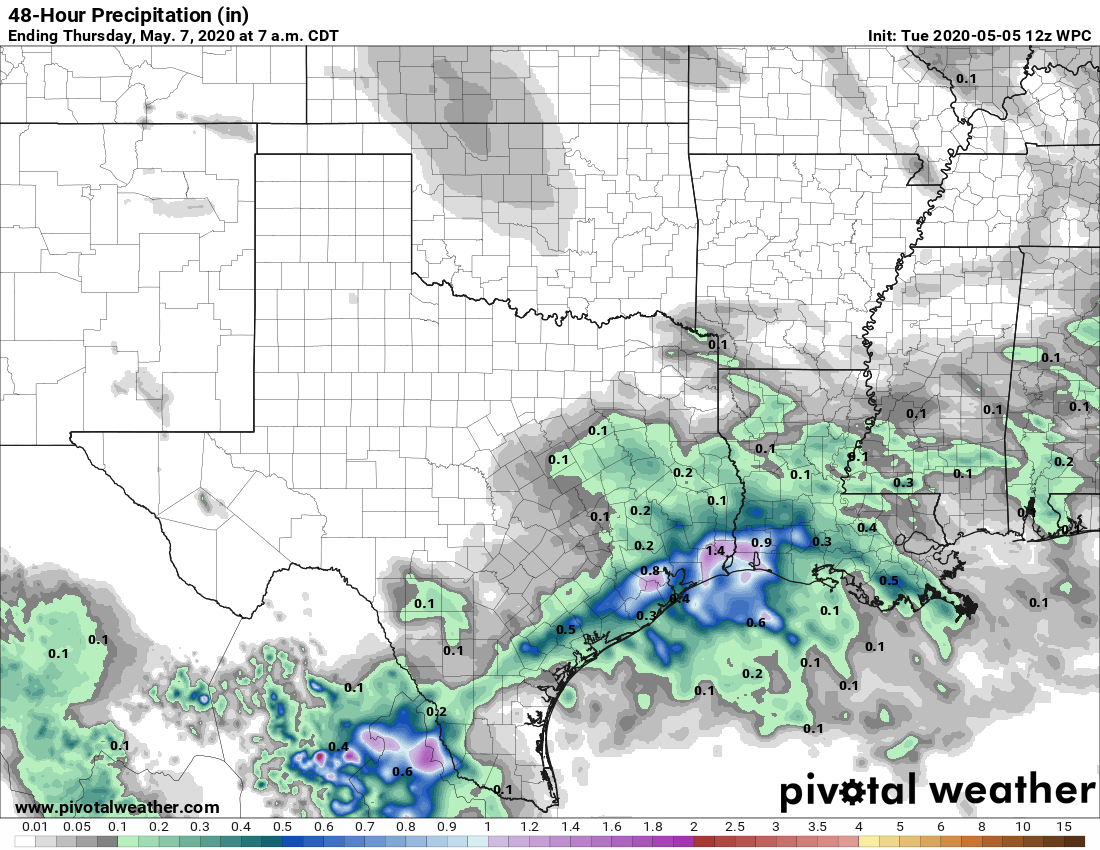
After Houston hit 91 degrees on Monday, the region will see another warm and humid day with highs in the upper-80s. However, a few more clouds today should help moderate highs just a bit. A front will approach, and move through Houston later today and tonight. I’d like to say we have confidence in rainfall amounts, but we don’t. Chances are probably a little better south of Interstate 10—about 50 percent—than further inland. Models are hinting at a band of rain showers that produces 1 inch or more of rainfall, with possibly some hail and damaging winds, but this activity probably will not be too widespread. The best chance of storms likely will occur between the evening hours Tuesday and sunrise on Wednesday.

Rain chances are highest south of Interstate 10 on Tuesday evening into Wednesday morning. (Pivotal Weather)

Wednesday

After sunrise, skies should begin to clear on Wednesday, and we should see a mostly sunny afternoon with highs in the mid-80s. Wednesday evening looks spectacular, with drier air filtering in. Lows Wednesday night will probably drop to around 60 north of Houston, with warmer weather along the coast.

Thursday

Another pleasant, sunny day, with highs in the 80s. As winds turn to come from the south, moisture levels will pick up. The effect of this will be increasing clouds Thursday night with muggier air, and lows in the low 70s.

See full post

A pair of fronts this week will remind us summer hasn’t come yet

Good morning. Houston will see a couple of chances for showers this week, but for the most part we should see partly to mostly sunny weather. And I don’t want us to get too far ahead of ourselves, but it sure looks like this weekend could see some really nice weather for May. Some areas may see sunshine with highs in the upper 70s, if you can believe that.

Monday

Temperatures have fallen to around 70 degrees for most of Houston this morning, and we’ll see a mix of sunshine and clouds this morning before likely full sunshine this afternoon. Highs today will rise to about 90 for most of the area, although they won’t quite reach that mark along the coast. Winds will be light, generally out of the south. Overnight lows will again likely remain at or above 70 for most of the area, with sinking air under the influence of high pressure.

It will be a hot day in Texas on Monday for early May. (Pivotal Weather)

Tuesday

This will be another hot day, with highs around 90 degrees, and partly sunny skies. An approaching cold front will mix things up, however, by late afternoon or evening. The front should reach northern areas of the region (such as College Station) a few hours before sunset and then push off the coast by Wednesday morning. I would like to be able to say with confidence what will happen rain-wise Tuesday evening and during the overnight hours, but a number of scenarios are open to us. The front could push through with only very light, scattered showers, or at some point during the boundary’s passage thunderstorms could break out dropping a quick 1 or 2 inches of rain on a few areas.

See full post

May’s first weekend to usher in another taste of summer for Houston

If you like sunshine and pleasant temperatures, enjoy the rest of this morning. If you like sunshine and increasing humidity, enjoy the next several days. If you like rain, I sincerely apologize.

Today

Friday is opening in the upper-50s to low-60s, a fine morning with nothing more than a few passing high clouds. We will warm up quickly this morning and afternoon. Look for us to see highs in the mid-80s this afternoon with mostly sunny skies and mostly light to moderate winds.

Weekend

Both Saturday and Sunday look fairly similar in terms of weather. We could see some morning low clouds, especially on Sunday, giving way to mid to late morning sunshine. If we want to be overly cautious, we will mention that both mornings could see some very light rain or sprinkles underneath any of those low clouds. But the afternoons should be fine.

Winds will pick up a bit this weekend, with daytime winds out of the south around 5 to 15 mph, gusting to 20 mph, especially close to the coast and to the west of Houston.

Wind gusts on Saturday afternoon will be around or a bit above 20 mph at times along the coast and well inland, west of Houston. (Weather Bell)

High temperatures on Saturday will peak in the mid to upper-80s and Sunday in the upper-80s. Some spots north and west of Houston will likely test 90 degrees by Sunday. Morning lows will be generally in the 60s, though Sunday could be around 70 degrees or so.

See full post