Tropical disturbance may form in the Gulf this week

Last week, we briefly mentioned the possibility of a disturbance forming in the Gulf of Mexico in early June, and that now appears more likely to happen. We have plenty of more questions than answers, and the most important message we can offer right now is to not be overly concerned with this. Watch it, yes, and we will. But we don’t know whether a tropical storm will even form, whether it will strengthen, or where it will ultimately go. So let’s talk about what we do know.

Tropical Storm Amanda will likely cross into the Gulf of Mexico on Monday. (NOAA)

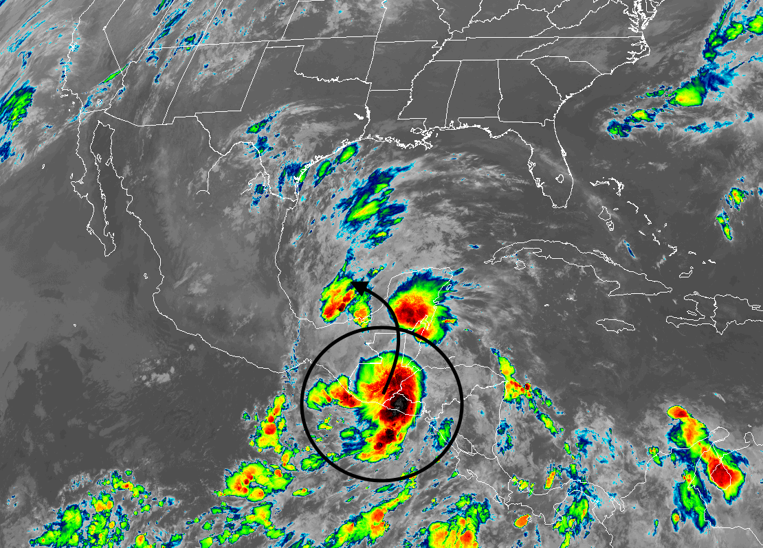
Tropical Storm Amanda formed in the Pacific Ocean early this morning south of Guatemala, and it will bring very heavy rainfall to Central America over the next couple of days as it moves generally northward. Its center, likely to weaken into a depression or weak low-pressure system, will then probably move into the southern Gulf of Mexico by Monday or Tuesday. At that point it should find favorable conditions to potentially strengthen some time next week. The National Hurricane Center now rates it as having a 50 percent chance of development over the next five days. If it does so, it probably would be renamed Cristobal.

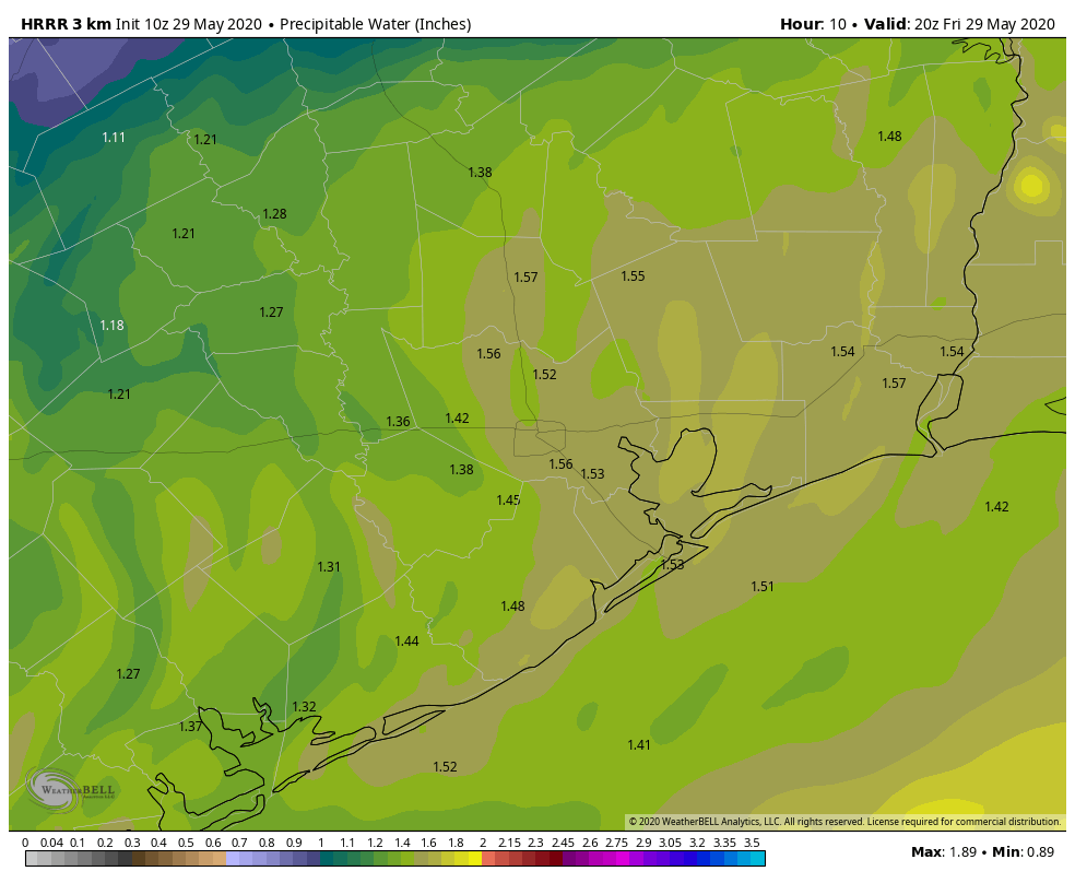
Most of our best model guidance suggests that steering currents will be relatively weak for a couple of days, perhaps into Thursday. And as the tropical system cools its heels this will make for very wet conditions in Mexico, likely most acutely in the states of Veracruz, Tabasco, and Campeche. Perhaps by later Thursday or Friday this low pressure system—which could be a tropical depression or storm by then—will begin to lift north.

European ensemble model forecast for “low” locations next Saturday night. (Weathernerds)

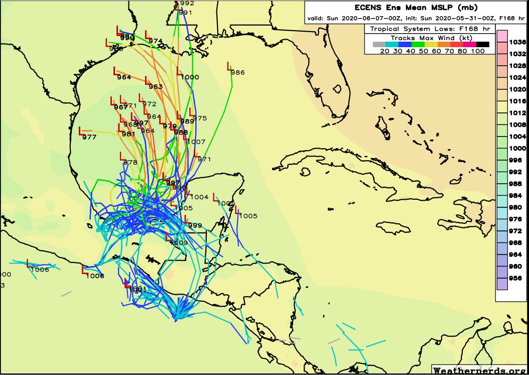
After that it is difficult to say much intelligible. There are several factors at play, including a ridge of high pressure over the southeastern United States. Depending on the strength of this ridge, it could push a tropical system near Texas or Louisiana about one week from today. Most likely, this system will be of the tropical storm variety, given that it is only early June. However, the Gulf of Mexico waters are warmer than normal, so there is at least a chance (20 percent, perhaps?) that the storm strengthens into a hurricane. In any case, the biggest threat is probably rainfall, and toward the end of next week it’s possible that some location along the Gulf Coast picks up a healthy amount of precipitation. While this could occur anywhere from northern Mexico to Florida, Texas is very much in play based on the latest model guidance.

Quieting down this weekend; heating up a bit next week

More storms impacted the region yesterday, mostly on the south and east sides of Houston. Thursday’s star of the show was a supercell over Galveston Bay that produced nearly 70 mph winds on the Texas City levee and multiple waterspouts in the bay.

We see waterspouts fairly regularly around here, but this was one or two levels above a typical one. Really impressive structure and intensity with that storm. Thankfully, this remained over water, though it did come very close to producing a tornado on Galveston Island.

We also do think that this pattern of nasty, over-productive daily thunderstorms has begun to wind down. Houston starts the transition to something very summer-like heading into the weekend.

Today

With the upper level storm that’s been sitting off to our northeast, we’ve been stuck in a pattern with winds aloft out of the northwest, bringing disturbances our way each day that have helped to invigorate our daily storms. That upper level system rockets off to the north and east today, integrated into a passing disturbance over the Great Lakes. Along with that, the amount of atmospheric moisture available is a little lower today, and the forecast of instability on the models is also substantially lower. I think that should be enough to limit just how widespread and strong showers and storms can get this afternoon.

Precipitable water, or roughly how much atmospheric moisture is available is still high enough for some scattered showers today, but it is substantially lower than it has been the last 2 days. (Weather Bell)

So what does it mean? It does mean another chance for showers or a thunderstorm today, however they should be somewhat kinder and gentler than those of the last few days. The highest chances today will be close to the coast or off to our east. That doesn’t mean a shower or storm can’t happen elsewhere; it’s just more likely closer to the sea breeze. We will see a mix of clouds and sun otherwise. Humidity will be low for this time of year, which should allow high temperatures to get to near 90 degrees this afternoon without much trouble.

Saturday & Sunday

We should settle back into a typical summer type pattern of sun, clouds, hot weather, and perhaps a brief passing shower. High pressure starts to flex, which will really drop the rain risks. The best odds look to be mostly toward Matagorda County, Wharton County, or southern Brazoria County. Unlike the last few days where we’ve seen storms blow up, anything this weekend would probably be slow to develop and max out maybe as a brief downpour and likely nothing worse. Humidity will increase a bit further, and we’ll see highs again around 90 degrees, give or take. Saturday and Sunday morning’s lows will be around 70 degrees, a little warmer at the coast and a little cooler farther inland.

See full post

One more day of storms before Houston’s weather settles down

We anticipated some rain, some hail, and damaging winds on Wednesday afternoon and evening in the Houston region, but we did not quite expect what we got. The primary damage came from strong wind gusts of 65mph or higher, which knocked down fences, and trees into power lines and structures. At one point more than 275,000 CenterPoint customers were without power. We expect one more shot of rain and storms today, although not quite as significant, before our weather calms down heading into the weekend.

Thursday

Unfortunately the setup today is similar to Wednesday, in terms of the overall pattern, but should be less intense. We expect generally sedate—and rather pleasant, for late May—weather this morning. However daytime heating will help generate the threat of strong thunderstorms later today, with the threats of wind and hail. Rainfall accumulations should be less for most people, as should areal coverage. Hard to say where the biggest threat lies, but most of the models are suggesting it will be closer to the coast than far inland today. Highs will be in the upper 80s, with sunshine this morning before clouds develop later today.

Severe weather is possible today, but the overall threat is lower. (NOAA)

Friday

A weak front should arrive sometime on Friday morning, bringing with it an end to rain chances. This will usher in something of a drier air mass heading into the weekend, and we should see clearing skies throughout the day. Highs will likely reach 90 degrees.

See full post

Severe Thunderstorm Watch & hail risk through Wednesday evening

Storms have exploded northwest of Houston today with numerous reports of large hail, up to as big as golf ball size or larger. As I write, this large hail is possible near Bryan in the Brazos Valley.

Radar shows strong and severe storms in the Brazos Valley racing southeast toward the Houston area this afternoon. (College of DuPage)

As a result of this, a Severe Thunderstorm Watch has been hoisted for the entire Houston area through 9 PM this evening. The main threat will be between now and 6 PM I think, however. These storms near Bryan-College Station are hauling south and east around 20 to 30 mph, and new storms are trying to blossom out ahead of them.

The main threat from today’s storms is likely to be large hail. Not everyone will see hail, but those that do (most likely along and north of I-10) could see hail to the size of golf balls or even a little larger. The hail threat today is legitimate. A secondary threat will be strong winds, capable of knocking down trees or power lines in spots. A very small tornado threat is there, but it’s not especially high at this time. We’re focused on hail and wind today I think. Heavy rain is also possible from any of these storms.

While the severe threat should fizzle after sunset, we may see additional rounds of showers or even some thunderstorms into later this evening. We’ll update again if things look more significant. But please stay weather aware through this afternoon and evening.