Delta rapidly intensifying as it nears Cancun, Gulf of Mexico

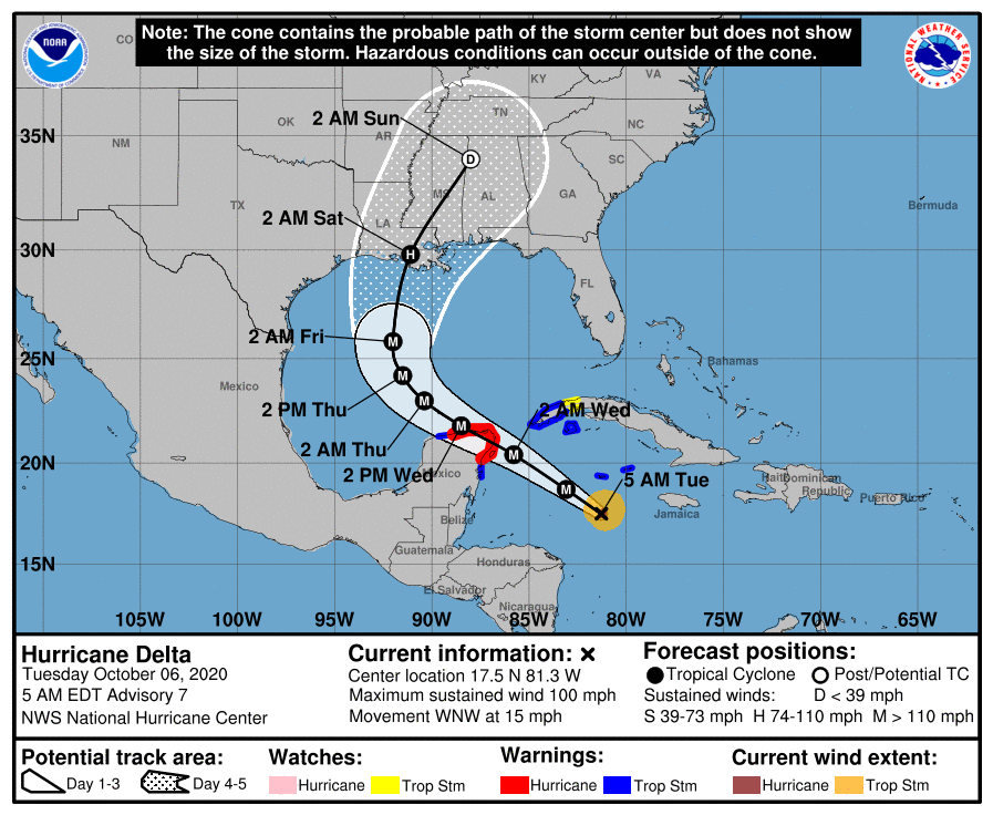
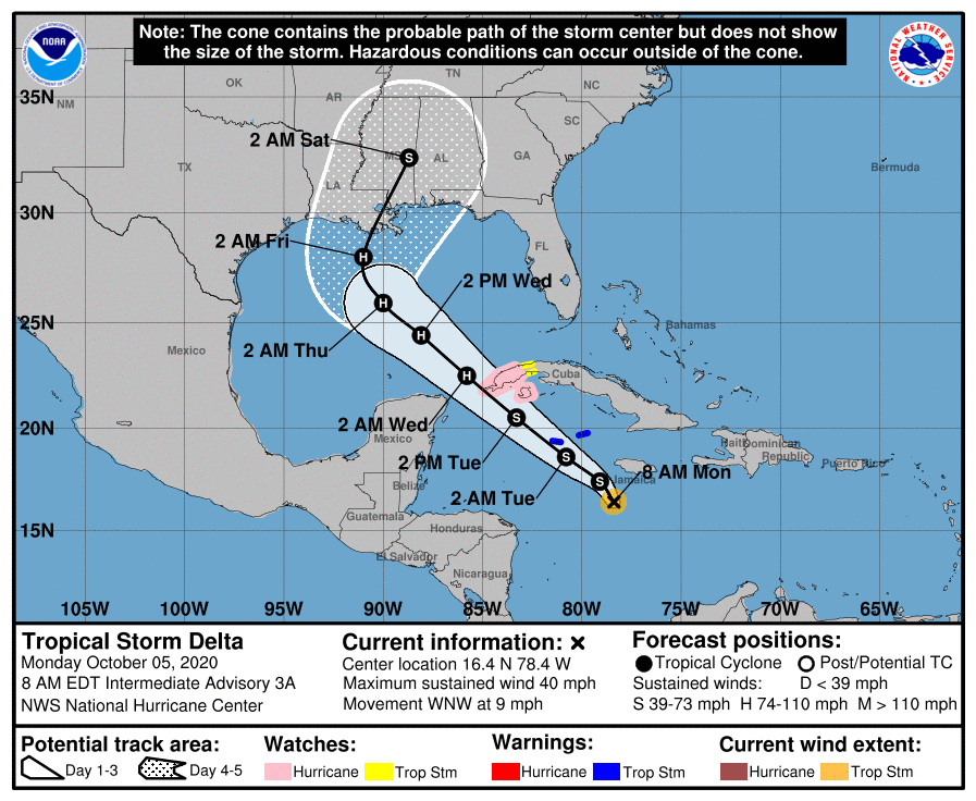
2:10pm CT Tuesday: We’re talking about Hurricane Delta this afternoon, which has undergone rapid intensification and is now a powerful Category 4 hurricane with 140 mph winds. (It was only named Delta 30 hours ago.) The storm will approach the Yucatan Peninsula tonight, and likely make landfall somewhere near Cancún early on Wednesday. This will be a dangerous hurricane for that area. By Wednesday evening the storm will be back out over the Gulf of Mexico, moving to the northwest.

Track

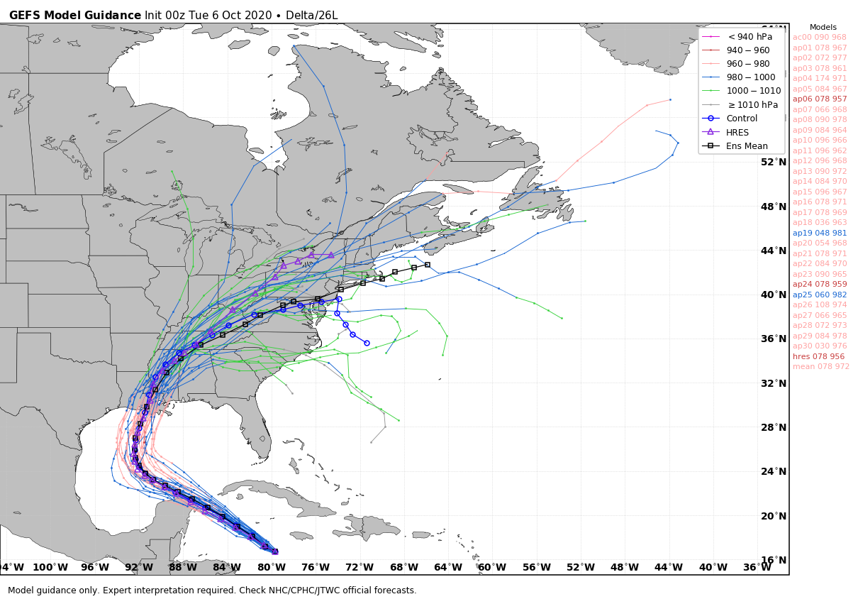
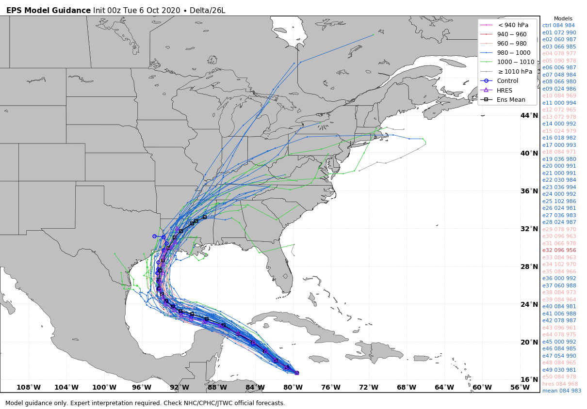
Overall, the track forecast remains largely unchanged. The 12z models are beginning to show a tighter cluster of solutions in which Delta moves to the west-northwest, or northwest for most of Wednesday and Thursday. Then, when Delta is a few hundred miles offshore from South Padre Island, it should begin a pretty sharp turn to the north. All of the best available guidance now shows a final landfall between the Texas-Louisiana border—very near where the devastating Hurricane Laura came ashore in August—and further east, around Morgan City and Houma. This tighter clustering of models is consistent with the National Hurricane Center forecast track, and increases our confidence in where Delta is going to go.

National Hurricane Center forecast track for Hurricane Delta at 10am CT.

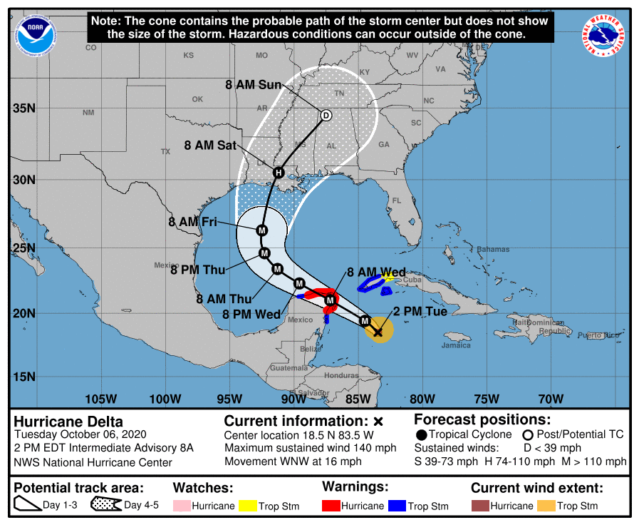
With that said, we are still roughly three-and-a-half days away from landfall, so the average track error is about 120 miles, and we also have to account for the possibility of wobbles. The bottom line with Delta’s track is that right now every available bit of evidence we have suggests this storm is going to turn toward Louisiana—but its future path is not 100 percent locked down.

Intensity

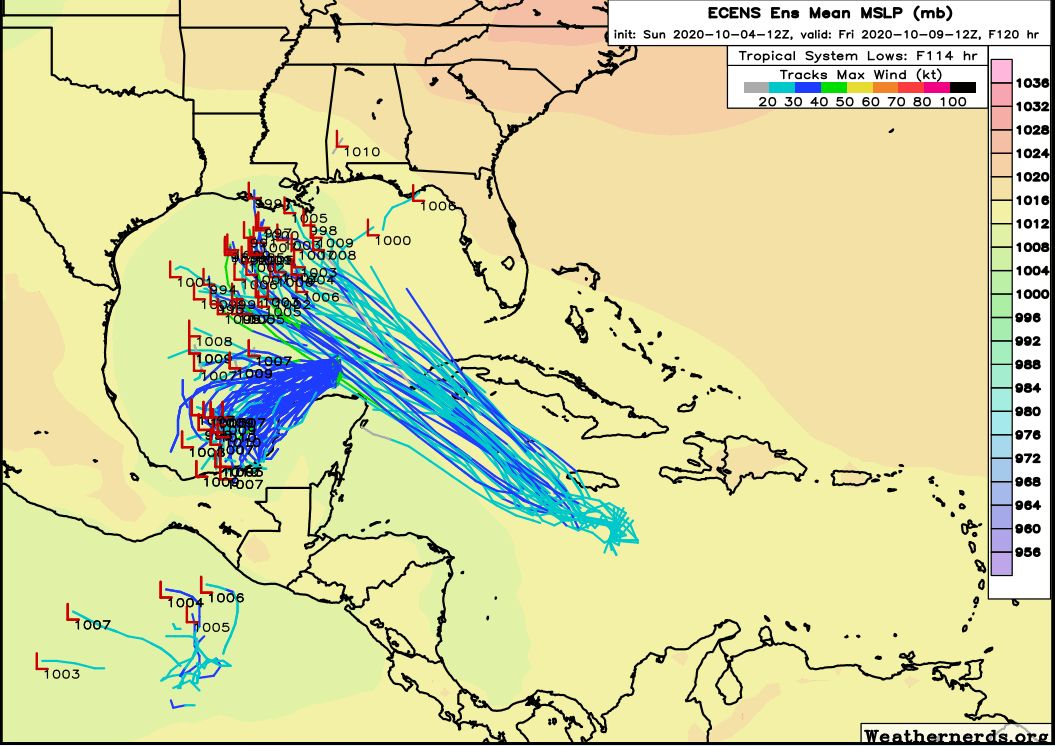
Delta has had near ideal conditions for strengthening over the last 24 hours, including very warm waters not just at the surface, but also below. This is important because, as the storm moves across the ocean it churns up seas from below, a process known as upwelling, which can bring cooler water to the surface. One measurement of an ocean’s depth of warm waters is its “Tropical Cyclone Heat Potential,” and basically any value of 80 or higher is conducive for intensification. As you can see from a recent map of this potential, the waters in the northwestern Caribbean Sea are explosively warm.

Plot of Tropical Cyclone Heat Potential. (NOAA/AOML)

This will begin to change as Delta moves away from the Southern Gulf of Mexico, at which time the storm also should begin to encounter more wind shear. These factors should help to limit the intensity of Delta as it moves toward the northern Gulf of Mexico, but it remains possible that this system could be a major hurricane at landfall.

Houston effects

Along this track Houston is likely to experience only very mild effects from Delta—perhaps some rain showers on Thursday, Friday or Saturday. Seas will reach their maximum on Friday, but should be below the levels the region experienced during Hurricane Laura.

Needless to say all of this depends upon the storm’s track, and if that changes significantly, so will our local forecast.

Our next update will come no later than 8:30 pm CT.

Hurricane Delta nears Gulf of Mexico, and we’ll need to watch the system

Good morning. The near term weather forecast for Houston will see more sunshine, and increasingly warm temperatures. Later this week our weather may, or may not, be affected to some extent by Hurricane Delta—which should become a major hurricane and move into the Gulf of Mexico. It will be discussed in depth.

Tuesday

Under the influence of high pressure, Houston will see sunny skies, with highs rising into the mid-80s or so, along with a slight northeasterly wind. We should squeeze out one more reasonably cool evening on Tuesday night, with lows sliding down to around 60 degrees for inland areas, and increasingly warmer conditions toward the coast.

Wednesday

Expect temperatures to be a degree or two warmer on Wednesday, with more sunny skies. Lows Wednesday night will be several degrees warmer, possibly not falling below 70 degrees in the city and points southward.

Thursday, Friday, and beyond

Our weather for these days will be determined by the track of Hurricane Delta, which remains somewhat uncertain. For now we’d expect a modest increase in rain chances on Thursday and Friday before mostly sunny and warm conditions this weekend, with highs of around 90 degrees. But we need to see what Delta does.

Hurricane Delta

Two things have happened during the last 24 hours that have moderately raised our concerns with regard to Delta and Houston. One, the storm has rapidly intensified, reaching sustained winds of 100 mph. It is expected to become a major hurricane before landfall. And two, there has been a westward drift in the forecast models that may bring the storm closer to Texas than anticipated. Let’s start with the track.

National Hurricane Center track forecast for Delta as of 4am CT Tuesday.

The National Hurricane Center track has shifted slightly west in response to the models, but remains centered on Louisiana. And in looking at the latest model guidance this morning, the general westward trend in the models seems to have stopped, so the current track seems reasonably on point.

Along this track we expect a major hurricane to come ashore the Yucatan Peninsula on Wednesday, with strong winds becoming a real problem for areas including Cancun. After this time the storm will move northwest across the Gulf of Mexico—toward Texas. The storm will be steered by high pressure over Florida and the Southeastern United States.

However, global models suggest this ridge will weaken this week, allowing Delta to being turning more toward the north by Thursday, bringing the hurricane to the northern Gulf coast by late Friday or early Saturday. Along this track, impacts from the storm will remain to the along the coast, in terms of swells, and to east of the greater Houston region. However, it’s going to be a fairly close thing as some models bring the storm pretty close to Texas before it turns. The National Hurricane Center track is in good agreement with the GFS model ensembles (shown below), which handled Hurricane Laura well earlier this year.

00z GFS model ensemble forecast for track of Hurricane Delta. (Weather Bell)

The National Hurricane Center forecasters suggest there may be a westward bias in the European model ensembles (shown below) that brings Delta the closest to Texas, like we saw with Hurricane Laura. This seems plausible, as the European model is west of most of the rest of the forecast models. For what it’s worth, I agree with this idea. The bottom line is that we’re going to need to keep close tabs on Delta to make sure it makes that turn, even if we’re reasonably confident it will turn. Needless to say, along the official forecast track, a strong hurricane coming to Louisiana after Hurricane Laura and other systems this year would make for an unwelcome mess.

00z European model track guidance for Hurricane Delta. (Weather Bell)

Intensity

In terms of intensity, Delta has continued to deepen this morning in response to extremely warm waters and low shear. It will find similar conditions in the southern Gulf of Mexico before increasing wind shear later this week in the northern Gulf, and cooler waters closer to land, should lead to a weakening trend as it approaches land.

The bottom line is that we’re going to have to keep a close eye on Delta for a few days, as it is likely to be a fairly close call for Texas. Our next update will be posted no later than 2:30pm CT today.

Tracking storms Gamma and Delta, and lots of sunshine for Texas

Good morning. Our forecast remains one of ample sunshine and warm weather for Houston, along with the return of humidity by the middle of the week. By next weekend highs could again approach 90 degrees as summer lite returns to the region for a spell. Meanwhile, we’re keeping a tab on the active tropics, but continue to see no direct threats to Texas.

Monday

Another weak front moved through the region on Sunday, and as a result today should be spectacular in Houston. Expect highs in the low 80s, sunny skies, and reasonably dry air. We will see a pleasant night tonight, with lows dropping into the 50s for areas well inland, while remaining warmer in the city, and closer to the coast. Winds will generally be light, out of the northeast.

Monday night should be the coolest night of the week for Houston. (Pivotal Weather)

Tuesday and Wednesday

Pleasant weather continues, albeit with a slight warming trend into the middle of the week as highs push into the mid-80s. Skies should remain mostly sunny.

Thursday and Friday

Our weather toward the end of the week will depend upon the track of what may be Hurricane Delta. Most likely, we will see a slight increase in rain chances, along with continued mostly sunny skies. Look for highs in the mid- to upper-80s with increasing humidity.

Saturday, Sunday, and beyond

Highs this weekend should approach 90 degrees under mostly sunny skies. This will be one of our last, best chances to hit 90 degrees this year so if that’s your thing—do your thing. If fall-like weather is your thing, early indications suggest a reasonably strong front may reach Houston by the middle of next week.

Tropics

We’re tracking two systems that are going to play in the Gulf of Mexico this week. Let’s start with what appears to be the bigger threat to the United States—newly formed Tropical Storm Delta. The system is on track to move from the Caribbean Sea into the Gulf of Mexico on Tuesday night, and should continue to the northwest before finding the edge of high pressure, after which time it should move north.

4am CT track forecast for Delta. (National Hurricane Center)

There is some question whether the final landfall location will take place over Louisiana, or to the east. If the track moves closer to western or central Louisiana, our region could see some slightly elevated winds and seas on Thursday and Thursday night, but right now our expectation is that it probably remains far enough east of Houston to preclude us from seeing really notable changes.

In terms of intensity, the storm has seen increasing convection this morning, and should find favorable conditions over the very warm Caribbean Sea to intensify further. The National Hurricane Center forecasts the storm to reach 105 mph sustained winds by Thursday, after which some weakening could begin due to shear and cooler waters in the Northern Gulf of Mexico. Lots of uncertainty remains regarding intensity.

As for Tropical Storm Gamma, there are two potential outcomes, I think. One is that the storm spins around the southern Gulf of Mexico long enough that it eventually dissipates later this week. The second option is that some kind of a weak system gets pulled north, toward Louisiana, behind Delta. For now, I’d bet on the former option.

4am CT track forecast for Tropical Storm Gamma. (National Hurricane Center)

We’ll be tracking the tropical activity closely, and will update later today if the forecast changes significantly.

Sunday tropics update with two storms threatening the Gulf

Jumping in here with a post because we’ve received several questions about the tropics now that potentially two storms may move into the Gulf of Mexico this week. Overall, our thinking has not changed. While the Gulf may may be busy in the coming days, the chance that anything significant tracks into Texas remains quite low. Let’s discuss.

Tropical Storm Gamma

Gamma remains a relatively strong tropical storm today, but it is now faces increasing wind shear. The overall intensity and track of the storm remain uncertain, but it generally is expected to weaken and remain around the Yucatan Peninsula and southern Gulf of Mexico for several days. As a result, Gamma will produce heavy rainfall this week over portions of southeastern Mexico, the Yucatan Peninsula, Central America, and far western Cuba. We have some questions about what happens by Wednesday or Thursday.

Tropical Storm Gamma forecast as of 4pm CT Sunday. (National Hurricane Center)

Potential Tropical Cyclone 26

This storm has more potential to intensify as it moves over the very warm waters of the northwestern Caribbean Sea, and into the Gulf of Mexico by later Tuesday or Wednesday. Officially, the National Hurricane Center suggests it could become a Category 2 hurricane (it would be named Delta) by the middle of next week, but it could easily be stronger or weaker than that. Here’s the track forecast.

Potential Tropical Cyclone 26 forecast as of 4pm CT Sunday. (National Hurricane Center)

European model ensemble forecasts

Now, this is a fairly messy forecast due to the potential proximity of Gamma and PTC 26. We can see this by looking through some of the European model ensemble tracks for next week. First up is the position forecast for Wednesday morning, showing Gamma hanging out in the Bay of Campeche, and PTC 26 just moving into the Gulf of Mexico.

European ensemble forecast for 7am CT Wednesday. (Weathernerds)

By Friday we can see there is some potential for interaction, and this is why we have some uncertainty in the overall track for later next week. Here’s the map for Friday morning:

European ensemble forecast for 7am CT Friday. (Weathernerds)

At this point, our biggest question is what happens to Gamma. It’s not clear whether the storm will get pulled north behind PTC 26, or continue to swirl around the Southern Gulf of Mexico for awhile longer.

Now let’s jump ahead 24 hours, to Saturday morning. By this time PTC has found the western edge of high pressure over Florida and the western Atlantic Ocean, and begins its turn north.

European ensemble forecast for 7am CT Saturday. (Weathernerds)

For PTC 26, the most likely scenario is that it will move into Louisiana as some kind of tropical storm or hurricane next Friday or so. There is generally pretty good model agreement in this outcome for PTC 26. As for Gamma, it’s either going to fizzle in the southern Gulf of Mexico or, potentially, follow PTC 26 northward. If this happens, it’s likely that a fairly weak system will follow PTC 26 into the northern Gulf of Mexico coast next weekend.

The bottom line is that there is some uncertainty about the track of both of these systems, and it is complicated by their potential proximity later this week. However, all of the available evidence suggests that neither system is likely to make much of an impact on Texas, aside from swells along the coast. We’ll be closely watching for the possibility of of changes, of course.