Good morning. Our forecast remains one of ample sunshine and warm weather for Houston, along with the return of humidity by the middle of the week. By next weekend highs could again approach 90 degrees as summer lite returns to the region for a spell. Meanwhile, we’re keeping a tab on the active tropics, but continue to see no direct threats to Texas.
Monday
Another weak front moved through the region on Sunday, and as a result today should be spectacular in Houston. Expect highs in the low 80s, sunny skies, and reasonably dry air. We will see a pleasant night tonight, with lows dropping into the 50s for areas well inland, while remaining warmer in the city, and closer to the coast. Winds will generally be light, out of the northeast.
Tuesday and Wednesday
Pleasant weather continues, albeit with a slight warming trend into the middle of the week as highs push into the mid-80s. Skies should remain mostly sunny.
Thursday and Friday
Our weather toward the end of the week will depend upon the track of what may be Hurricane Delta. Most likely, we will see a slight increase in rain chances, along with continued mostly sunny skies. Look for highs in the mid- to upper-80s with increasing humidity.
Saturday, Sunday, and beyond
Highs this weekend should approach 90 degrees under mostly sunny skies. This will be one of our last, best chances to hit 90 degrees this year so if that’s your thing—do your thing. If fall-like weather is your thing, early indications suggest a reasonably strong front may reach Houston by the middle of next week.
Tropics
We’re tracking two systems that are going to play in the Gulf of Mexico this week. Let’s start with what appears to be the bigger threat to the United States—newly formed Tropical Storm Delta. The system is on track to move from the Caribbean Sea into the Gulf of Mexico on Tuesday night, and should continue to the northwest before finding the edge of high pressure, after which time it should move north.
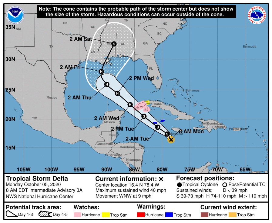
There is some question whether the final landfall location will take place over Louisiana, or to the east. If the track moves closer to western or central Louisiana, our region could see some slightly elevated winds and seas on Thursday and Thursday night, but right now our expectation is that it probably remains far enough east of Houston to preclude us from seeing really notable changes.
In terms of intensity, the storm has seen increasing convection this morning, and should find favorable conditions over the very warm Caribbean Sea to intensify further. The National Hurricane Center forecasts the storm to reach 105 mph sustained winds by Thursday, after which some weakening could begin due to shear and cooler waters in the Northern Gulf of Mexico. Lots of uncertainty remains regarding intensity.
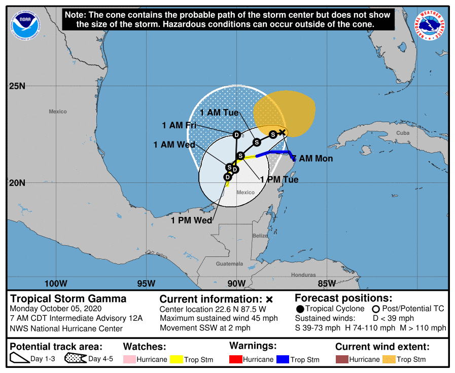
As for Tropical Storm Gamma, there are two potential outcomes, I think. One is that the storm spins around the southern Gulf of Mexico long enough that it eventually dissipates later this week. The second option is that some kind of a weak system gets pulled north, toward Louisiana, behind Delta. For now, I’d bet on the former option.
We’ll be tracking the tropical activity closely, and will update later today if the forecast changes significantly.

I’m loving the “spectacular” label on today’s forecast. And, while we’ll get another burst of 90-degree weather this weekend per the forecast, at least it will be gone again.
October is when I like to kick home projects into high gear: hurricane season is winding down and the weather makes things comfortable for a change. November isn’t so bad, either.
Can we just pause the clock/calendar here?
Anyone else notice an uptick in mosquito activity?
Since Beta, yes. And I’ve found them larger and unfortunately more capable than usual.
Oof I have too. One got me last night, and my kids were all bitten up and down their legs with some nasty welts.
After a long summer of low activity, these past few nights have been CRAZY. Hopefully the cooler weather drives them away soon enough.
Yes. I haven’t heard city trucks at all this summer for any spraying, which I attributed to COVID budgeting but we’re definitely getting the full impact of that 14 inches of rain so I’m wondering if city will do an exception spray. Louisiana lost livestock to mosquito swarms after Laura, which was the first I’d ever heard that could happen, so I’m hoping the livestock around Houston will do OK with the surge here.
Louisiana AGAIN??! Oh my. They just can’t get a break.
Nice piece about Theodore and the Lanzas in the morning paper. Foxhall even mentioned Space City Weather and Eric.
https://www.houstonchronicle.com/news/houston-weather/article/space-city-weather-tropical-storm-beta-baby-15620184.php
I always just keep up with the weather locally but my brother is in Cancun at the moment and this is extremely helpful, it helps me to know his situation weather wise. Thanks for all your work, big thank you.