Jumping in here with a post because we’ve received several questions about the tropics now that potentially two storms may move into the Gulf of Mexico this week. Overall, our thinking has not changed. While the Gulf may may be busy in the coming days, the chance that anything significant tracks into Texas remains quite low. Let’s discuss.
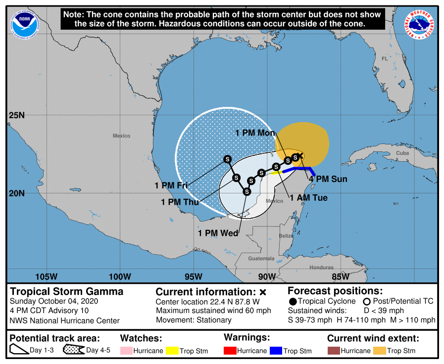
Tropical Storm Gamma
Gamma remains a relatively strong tropical storm today, but it is now faces increasing wind shear. The overall intensity and track of the storm remain uncertain, but it generally is expected to weaken and remain around the Yucatan Peninsula and southern Gulf of Mexico for several days. As a result, Gamma will produce heavy rainfall this week over portions of southeastern Mexico, the Yucatan Peninsula, Central America, and far western Cuba. We have some questions about what happens by Wednesday or Thursday.
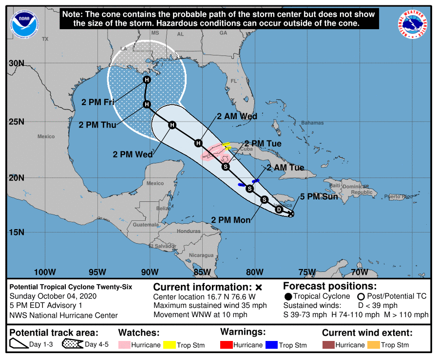
Potential Tropical Cyclone 26
This storm has more potential to intensify as it moves over the very warm waters of the northwestern Caribbean Sea, and into the Gulf of Mexico by later Tuesday or Wednesday. Officially, the National Hurricane Center suggests it could become a Category 2 hurricane (it would be named Delta) by the middle of next week, but it could easily be stronger or weaker than that. Here’s the track forecast.
European model ensemble forecasts
Now, this is a fairly messy forecast due to the potential proximity of Gamma and PTC 26. We can see this by looking through some of the European model ensemble tracks for next week. First up is the position forecast for Wednesday morning, showing Gamma hanging out in the Bay of Campeche, and PTC 26 just moving into the Gulf of Mexico.

By Friday we can see there is some potential for interaction, and this is why we have some uncertainty in the overall track for later next week. Here’s the map for Friday morning:
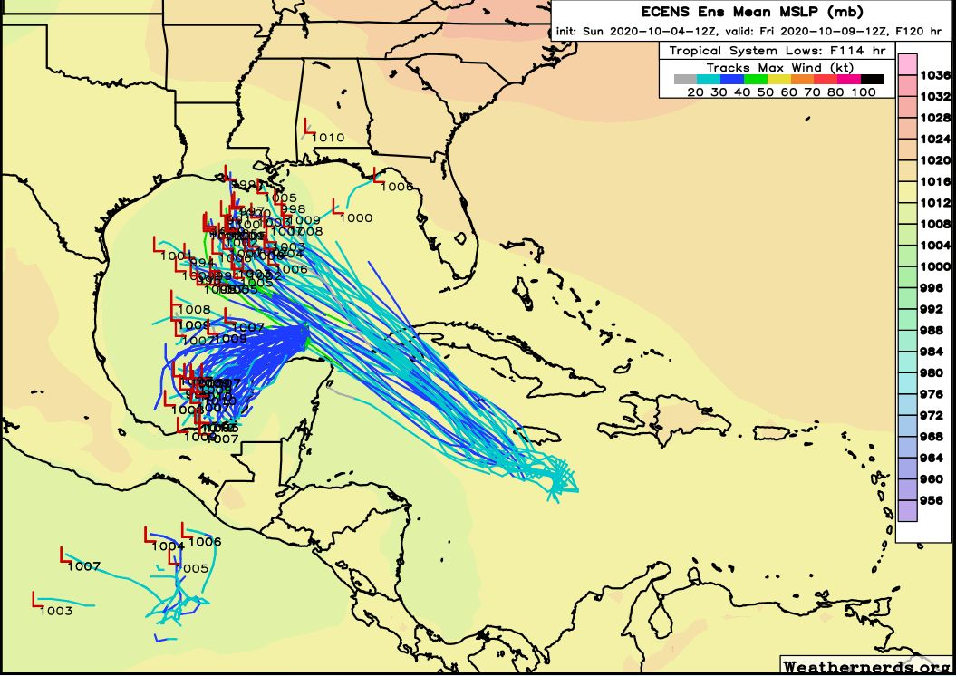
At this point, our biggest question is what happens to Gamma. It’s not clear whether the storm will get pulled north behind PTC 26, or continue to swirl around the Southern Gulf of Mexico for awhile longer.
Now let’s jump ahead 24 hours, to Saturday morning. By this time PTC has found the western edge of high pressure over Florida and the western Atlantic Ocean, and begins its turn north.

For PTC 26, the most likely scenario is that it will move into Louisiana as some kind of tropical storm or hurricane next Friday or so. There is generally pretty good model agreement in this outcome for PTC 26. As for Gamma, it’s either going to fizzle in the southern Gulf of Mexico or, potentially, follow PTC 26 northward. If this happens, it’s likely that a fairly weak system will follow PTC 26 into the northern Gulf of Mexico coast next weekend.
The bottom line is that there is some uncertainty about the track of both of these systems, and it is complicated by their potential proximity later this week. However, all of the available evidence suggests that neither system is likely to make much of an impact on Texas, aside from swells along the coast. We’ll be closely watching for the possibility of of changes, of course.
Thank you for the update, Eric! November 30th can’t get here soon enough!
Going from memory here, but the 2005 season went well beyond Nov 30. This is 2020. Who knows when the 2020 hurricane season will end.
Yep – December, 2005. And I think Zeta lasted into 2006!
https://en.wikipedia.org/wiki/2005_Atlantic_hurricane_season
Thanks for jumping in! Hoping that whatever weather systens are protecting the Texas coast stays in place. Prayers for Louisiana.
I know they are not likely to impact Texas but I have family in Louisiana and my church supports a mission in Biloxi so I hope you will continue to provide updates on he storms this week.
I thought Gamma was forecast to go into Mexico.
Thank you!
Thanks for all the good information. I enjoyed the article about Matt and family in the Chronicle this morning.