Spectacular autumn weekend ahead for Houston, while the tropics show no quit

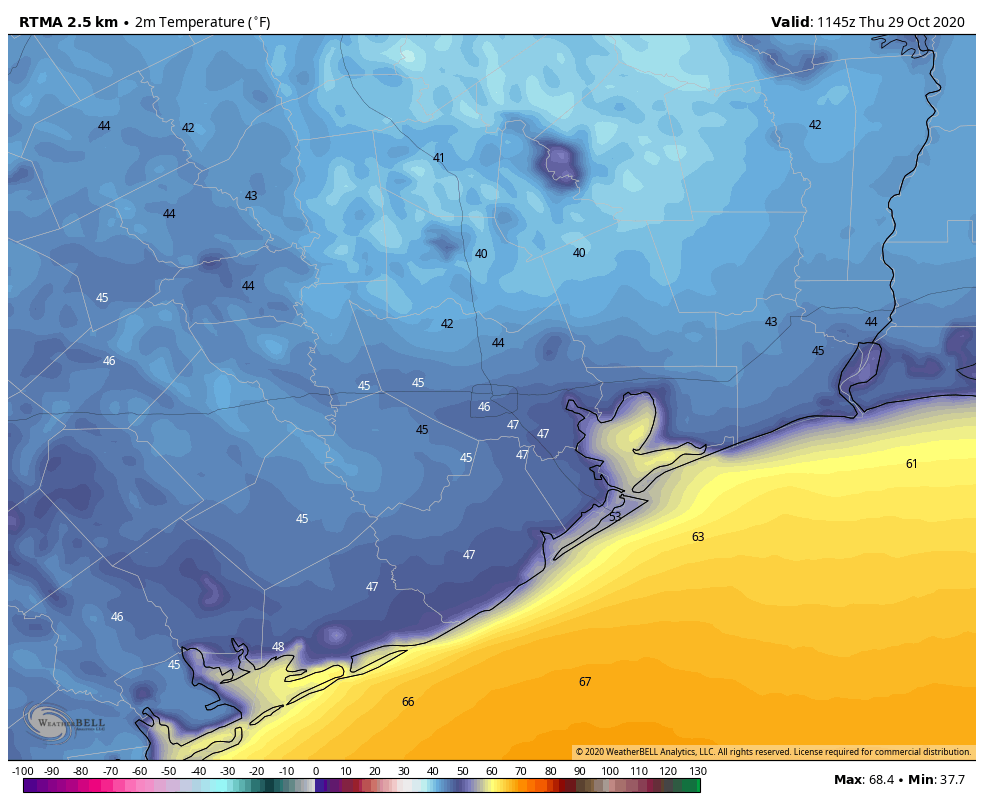
Good morning, and it’s a cool one again across the area. We have mostly 40s and some low-50s peppered in everywhere.
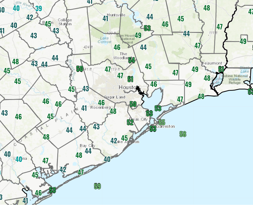
Temperatures are generally in the 40s and low 50s across most of the area this morning, a cool start! (NOAA)

Yesterday began one of the coolest but nicest stretches of weather for us in a long while that will continue through the weekend.

Today & weekend

Look for simply spectacular autumn weather all weekend long. We’ll top off in the upper-60s today with wall to wall sunshine. Look for low-70s tomorrow and mid-70s on Sunday. Morning lows will generally be in the mid-40s to mid-50s through Sunday. Winds should be lighter than they’ve been the last couple days.

For trick or treating, look for comfortable weather this year. Expect upper-50s to low-60s north and mid to upper-60s or a tick or two warmer in the city of Houston and points south.

Early next week

A reinforcing shot of drier, cooler air will arrive Sunday evening, so you’ll notice offshore winds kick up again later Sunday and on Monday. Look for cooler temperatures again Monday with highs in the 60s for most of us. Tuesday should see low-70s with lighter winds, and Wednesday likely sees mid-70s. Morning lows look cool on Monday and especially Tuesday. Look for upper-40s or low-50s Monday morning and mostly 40s on Tuesday morning.
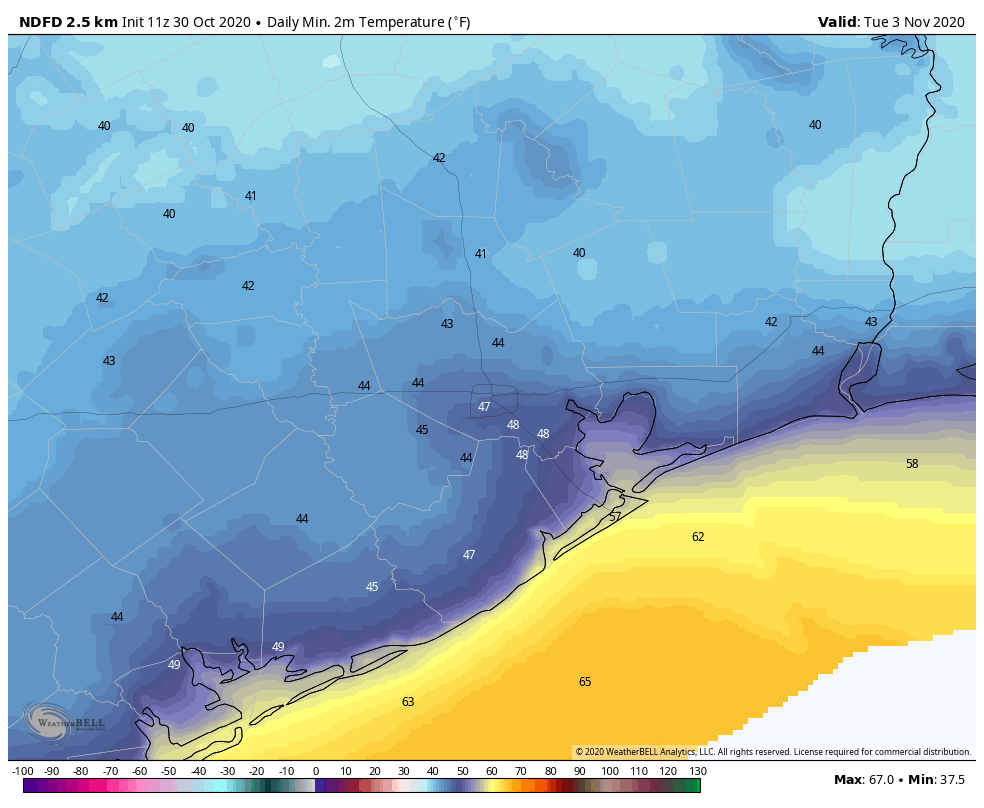
Morning lows on Tuesday will bottom out in the low to mid-40s most places. (NOAA forecast via Weather Bell)

Look for some high clouds and warmer temps to return on Wednesday, and that heralds a pretty substantial and possibly lengthy warm-up that may linger through next weekend and into the following week.

Tropics

We knew 2020 was going to be an active hurricane season, but the absurdity of it all has still been surprising. It’s really been non-stop in the Gulf, either dealing with a threat or looking ahead to the next one since Hanna struck South Texas back in late July. Hurricane Zeta may have been the most impressive of them all for how anomalous it was.

Zeta is the strongest known storm back to at least 1850 in the western Gulf this late in the hurricane season.

Zeta peaked at 95 kts. (and I wouldn’t be shocked to see it reanalyzed at 100 kts. (115 mph) in the offseason), which shatters the record of 75 kts. that far northwest in the Gulf for this late in the year. More impressively, Zeta’s intensity ramped up 40 kts. (45 mph) in 26 hours.

The previous record from late October onward was somewhere between 10-21 kts. In that respect, Zeta is in a league of its own. Hurricane season technically runs through November 30th, but in the western Gulf, we usually shut down in mid-October. Zeta obliterated that paradigm. Why? Well, it’s not that the Gulf is super-warm. In fact, Zeta continued steadily strengthening over cooler water in the northern Gulf. The amplified, weird pattern over the West and Plains, responsible for our cold front, the ice storm in Oklahoma and parts of Texas, and the snow in the Rockies helped supercharge Zeta as it approached Louisiana.

This was a case where shear was actually in a sweet spot for a storm and helped it along. The deep trough and very strong jet stream winds over Texas (known as a jet streak) actually helped Zeta find an environment that would be hospitable for a low pressure system to intensify within. This further underscores that water temperatures are far from everything when it comes to hurricane intensity. In this case we had a Gulf of Mexico that was only slightly supportive for a storm, but the storm got juiced by the atmospheric pattern over the Plains and Southeast. And the end result was a memorable, odd late season storm. Zeta also will end up being the strongest storm to make landfall so late in the season on the entire Gulf Coast. Zeta’s forward speed of over 45 mph over the Southeast made it one of the fastest moving storms on record (for any date) over the continental United States.

And we aren’t finished. The National Hurricane Center has 80 percent odds that a tropical wave in the Caribbean (dubbed Invest 96L) will develop into a depression or storm in the next 5 days.
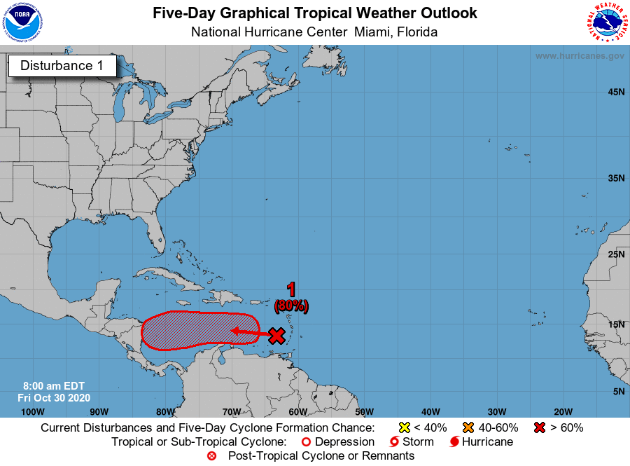
A tropical wave tagged as Invest 96L has an 80% chance of development over the next 5 days. (NOAA)

If it gets a name, it will be called Eta, and 2020 would officially tie 2005 for the most storms on record in the Atlantic basin. As much as it pains me to write this, Eta is a storm that should probably be watched from Louisiana to Florida. It’s likely to percolate off the coast of Central America much of next week before perhaps being ushered north next weekend by our next weather maker over the Plains & Texas. How exactly that plays out is TBD. This is highly unlikely to come to Texas, but there a number of model solutions that bring it into the eastern Gulf or off the Florida coast. So, yet again, another one for our neighbors to the east to watch. We’ll update you on Monday.

Cool, dry, and sunny weather expected in Houston for awhile

It’s quite cold across the region this morning, ranging from a few readings in the upper 30s in some parts of Montgomery County down to around 50 degrees right along the coast. It looks like Houston’s official station, at Bush Intercontinental Airport, probably will bottom out at about 42 degrees. This is chilly, but still 7 degrees warmer than the all-time record set in 2017. Incidentally, the earliest freeze ever recorded in Houston came on October 31, 1993.

Our forecast ahead is pretty straightforward. We should see generally cooler than normal weather through the middle of next week, and our next real chance of rain is unlikely for quite some time. Enjoy fall, y’all!

It is a chilly, almost winter-like morning across the upper Texas coast on Thursday. (Weather Bell)

Thursday

Today will not be so nice. Although sunshine will predominate, strong northerly winds will keep things on the unpleasant side Thursday. Highs will recover into the low 60s for most of the area, but northwest winds should gust today as high as 25 mph. Winds will back off slightly this evening, but it will still be a cold, clear, breezy night with lows falling into the 40s again for most of the region.

Friday

A damn near perfect day. Highs in the low 70s. A light wind. Ample sunshine. Lows Friday night will probably be a couple of degrees warmer.

Saturday and Sunday

By late Friday we should see winds swing around to come from the east, and then southeast, but the region won’t warm up too appreciably. Under sunny skies, highs should climb into the mid-70s for most, possibly touching 80 degrees by Sunday for some locations near the coast. Lows will remain solidly in the 50s. A reinforcing shot of cooler and drier air arrives Sunday evening or during the overnight hours.

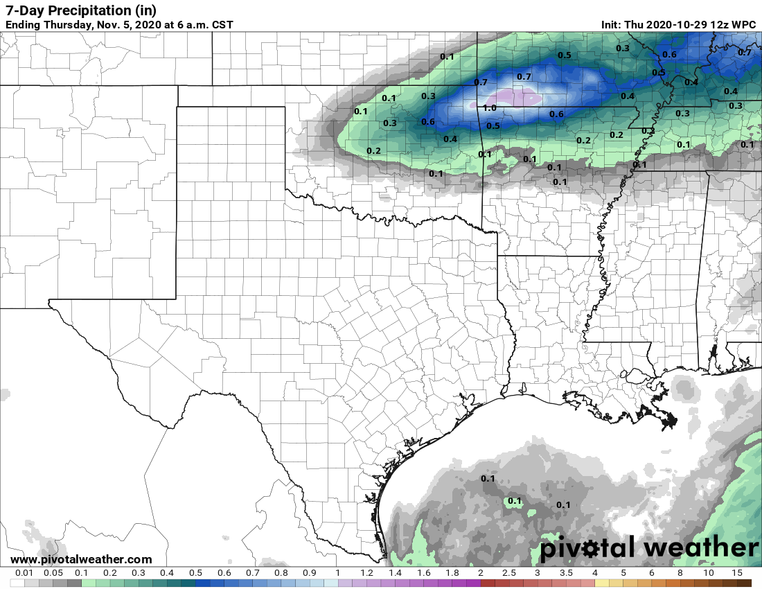
Here is the seven-day rainfall forecast for Texas from NOAA. It looks … dry. (Pivotal Weather)

Next week

Expect highs in the 70s and lows in the 50s through Wednesday. After that a warming trend is likely heading into the weekend, with highs rising to perhaps 80 degrees, and lows to around 60. As for rain chances, they’re going to remain low for awhile, at least until the end of the next work week.

Matt will have you covered tomorrow, when he’ll discuss all the records set by Hurricane Zeta as it strengthened Wednesday before making landfall in southeastern Louisiana—such a nasty, late season storm.

Cold front crosses Houston as Zeta strengthens, aims toward New Orleans

The cold front has finally pushed all the way into Houston and Galveston this morning, and it is going to be a cold day for the region. Yes, I said cold—as in temperatures this afternoon will likely remain in the 50s for much of the area. And the big change with this front is that it will have sticking power, as we anticipate cool, dry air hanging around into early next week. In today’s post we also discuss Hurricane Zeta, which is intensifying as it moves toward southeastern Louisiana and Mississippi.

Wednesday

The front has moved to the coast, but it still will require another shove to completely pass through. Essentially, as Hurricane Zeta moves into the Norther Gulf Coast today, and toward the northeast, this front will follow. In the meantime, we’re likely to see on-and-off light showers today, with northwest winds of 10 to 15 mph. Rains should end this afternoon, from west-to-east. As the front gets pulled away, we will see some clearing skies tonight, and lows should drop into the 40s for much of the area.

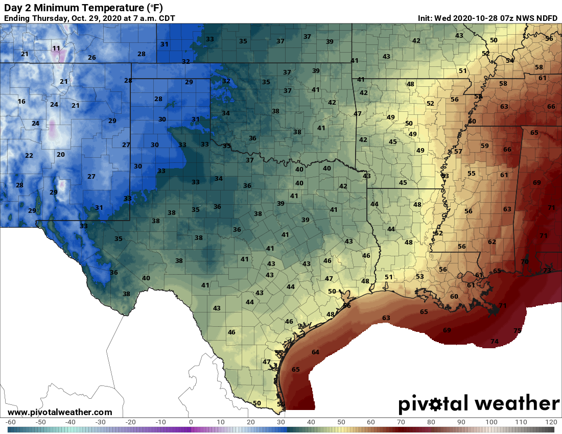
Here are the temperatures you’re going to wake up to on Thursday morning. (Pivotal Weather)

Thursday

Skies should be clear Thursday, but we’ll see fairly pronounced northwesterly winds as the front moves well clear of the area, perhaps gusting to 25 mph. Despite sunny skies high temperatures will probably crest in the mid-60s for most. It will be another cool, clear night with blowing winds.

Friday

Sunny, highs near 70. Damn near perfect.

Saturday and Sunday

This weekend will see fine weather too, with highs in the 70s, and lows in the 50s. A reinforcing front should reach the region by Sunday night or so, but with a dry atmosphere we don’t expect any rainfall.

Next week

The front should keep Monday and Tuesday of next week on the cool side, before we warm back up toward the 80s by Wednesday or Thursday. Rain chances likely won’t return until the end of next week, at the earliest.

Tropics

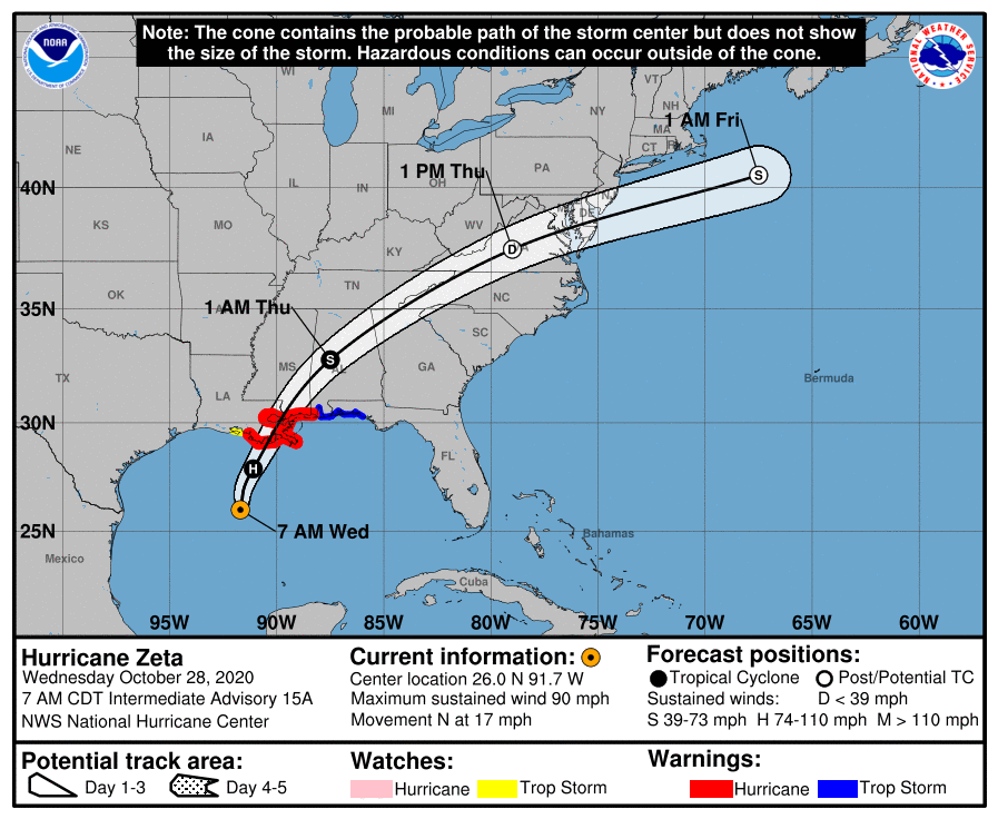
Zeta has strengthened into a hurricane overnight with 90-mph winds, and is moving rapidly toward the Mississippi River delta where it will likely make landfall this afternoon as a Category 2 hurricane. This will produce a greater than anticipated storm surge, particularly from the mouth of the Pearl River to Dauphin Island, Alabama.

Updated track forecast for Hurricane Zeta. (National Hurricane Center)

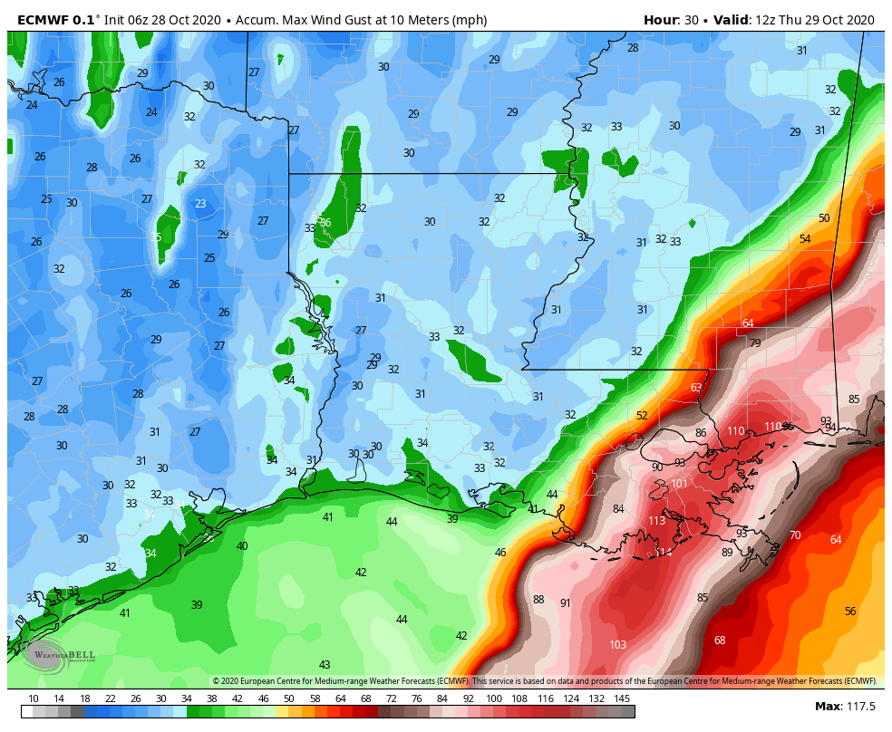
The storm is moving quickly enough that, although it will generate heavy rainfall, accumulations should generally be less than 5 inches for most areas as storms move through. The other big concern is wind, with hurricane-force wind gusts likely in New Orleans this afternoon.

Forecast for maximum wind GUSTS from Hurricane Zeta. (Weather Bell)

Conditions should rapidly improve in Louisiana and Mississippi after the storm passes, and this cold front follows through, with a sunny, placid weekend ahead for the northern Gulf of Mexico coast.

Front moves into Houston, and stops. Stronger push coming Wednesday

Houston’s weather this morning is something akin to the opening of Charles Dickens’ A Tale of Two Cities: It was the best of times, it was the worst of times. It was the coolest of times, it was the warmest of times. By this I mean that a cool front has sagged into the Houston region, and pretty much stalled right on top of our heads. To the west, it is cool and dry, to the east, much warmer and humid. Conditions will remain this way until the front bulls all the way through on Wednesday.

Tuesday

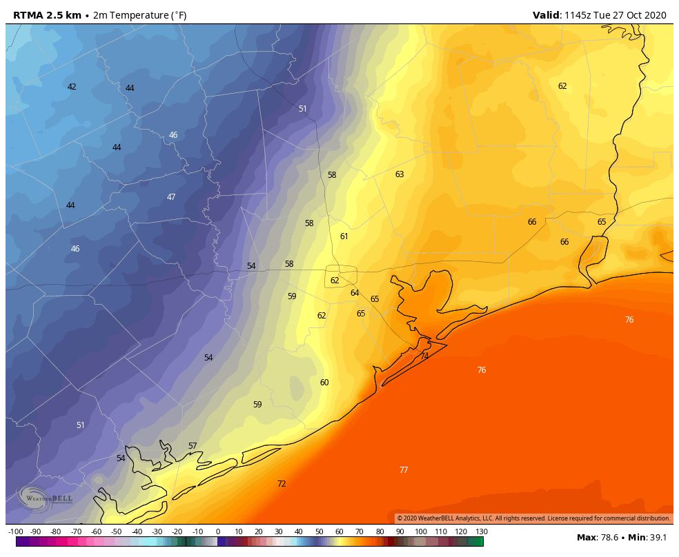
Temperatures are generally in the 50s this morning on the west side of town, in places such as Sugar Land and Katy. They are in the mid-60s in the central part of the city, and mid-70s along the coast and to the east. The line demarcating cooler and warmer air should waffle back and forth some today, and it’s impossible to predict precisely where with the front stalling overhead. So highs will vary from the 60s to 80s across Houston. Pretty remarkable. Skies should be mostly cloudy, with a few light showers possible.

That’s quite a temperature gradient as of 6:45am CT across Houston. (Weather Bell)

Wednesday

A reinforcing push of colder air arrives on Wednesday, probably during the middle of the day, and this will bring fall-like weather to the entire area. We should see some better rain chances during the day on Thursday as the front slogs through, primarily from shortly before sunrise into the late afternoon hours. I think most areas will see 0.25 to 1.5 inches of rain, and I don’t have high confidence in pinning down where. Temperatures will drop to around 50 degrees Wednesday night in the wake of the front—cooler inland, and warmer along the coast.

Thursday

This should be a breezy day due to a strong pressure gradient in the wake of the front, with gusts possibly as high as 30 mph. Please take note of this if you have outdoor activities planned. Skies will otherwise be clearing out, and highs likely will only get into the upper 60s in most locations as colder air moves in. Winds should back off some toward evening.

Friday, Saturday, and Sunday

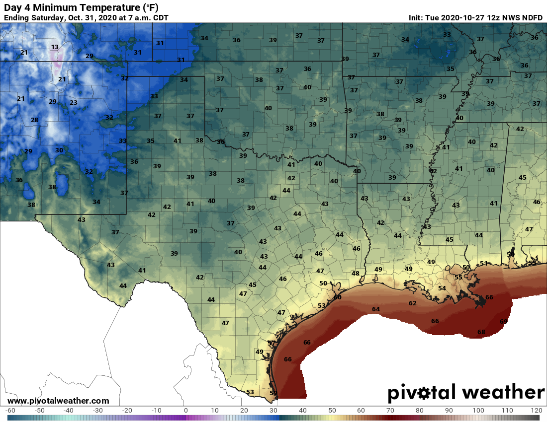
This weekend’s weather looks splendid, with sunny skies, highs in the upper 60s to low 70s, and overnight lows in the 50s. For those wondering about Halloween rainfall, there will be none this year. Enjoy!

This is what Thursday, Friday, and Saturday mornings will feel like. (Pivotal Weather)

Next week

The models are suggesting another front may arrive by around Monday to keep the cooler, drier pattern going. However, overall confidence in this is not yet high.

Tropics

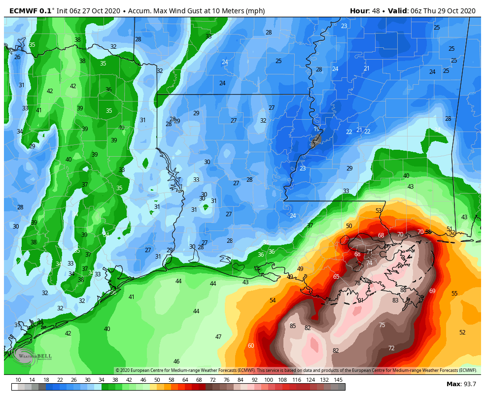
Tropical Storm Zeta crossed the Yucatan Peninsula during the overnight hours and is now emerging into the Gulf of Mexico as a strong tropical storm, with 70 mph winds. Confidence in a track toward the northern Gulf Coast is high, with the storm likely making landfall in southeastern Louisiana on Wednesday afternoon or evening. It should be a Category 1 hurricane at this time and its center may pass near, or directly over New Orleans.

European model forecast for wind GUSTS due to Zeta. (Weather Bell)

The storm will be moving quite rapidly to the northeast at this time, so while it won’t linger on Wednesday night, it could produce briefly very heavy rainfall and wind gusts above 90 mph over southeastern Louisiana. This is a nasty, late-season storm no one wants.