Downpours return, at least for some of the Houston area

It feels like it has been eons, but the last time it rained in the Houston area with any meaning was back on July 7th, or only about 10 days ago. Today will be our best chance since then at seeing some showers. Fortunately, we don’t foresee rain chances truly dropping to zero again anytime soon, but they will wax and wane as some features shuffle around the Gulf Coast. Let’s take a look.

Today

We have a weak disturbance coming at us today from Louisiana, and that will provide the impetus for scattered showers and thunderstorms, especially south and east of Houston. Radar is already lighting up this morning off the coast.

Showers and thunderstorms are numerous over the Gulf early this morning, and those will work toward coastal areas over the next few hours. (RadarScope)

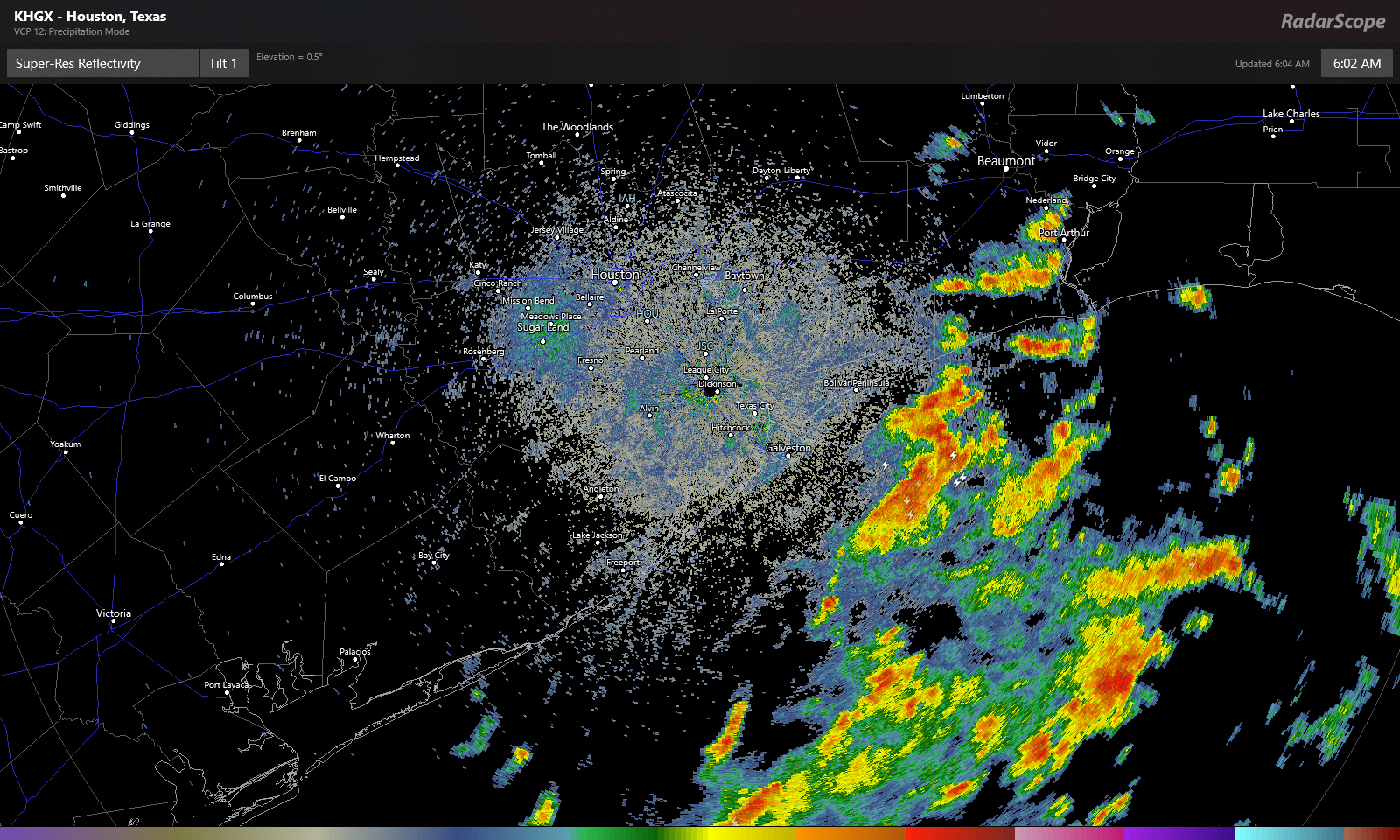
Look for these offshore showers and storms to move onshore through mid-morning. Numerous showers and storms are likely south and east of Houston this morning. They will gradually advance farther inland this afternoon, but we think they’ll probably stay primarily focused south of I-10. If we’re talking about inland rainfall chances today, Sugar Land or Wharton probably have a better chance at seeing some than The Woodlands or Hempstead. Whatever the case, some of the rain is bound to be locally heavy wherever it falls, and a few locations could easily see 2 or 3 inches, while others will see absolutely nothing today.

That disturbance shifts away from our area later today and tonight, leaving us just warm and humid for tonight. Depending on the coverage of clouds and storms today, we could see highs only top off in the low-90s briefly. Some coastal areas may not get much past the mid-80s. Houston again hit 100° yesterday, so it certainly may feel a little better today.

Weekend

It does not appear that we will have another disturbance this weekend like we have moving through today. This means we should probably expect fairly standard summer fare for southeast Texas. Look for highs in the mid-90s, lows in the upper 70s to near 80, and a standard 20-ish percent chance of a passing shower or storm with each day’s sea breeze off the Gulf. In general, you’ll be lucky if you see rain this weekend, but there will be showers around on both days.

Monday and Tuesday

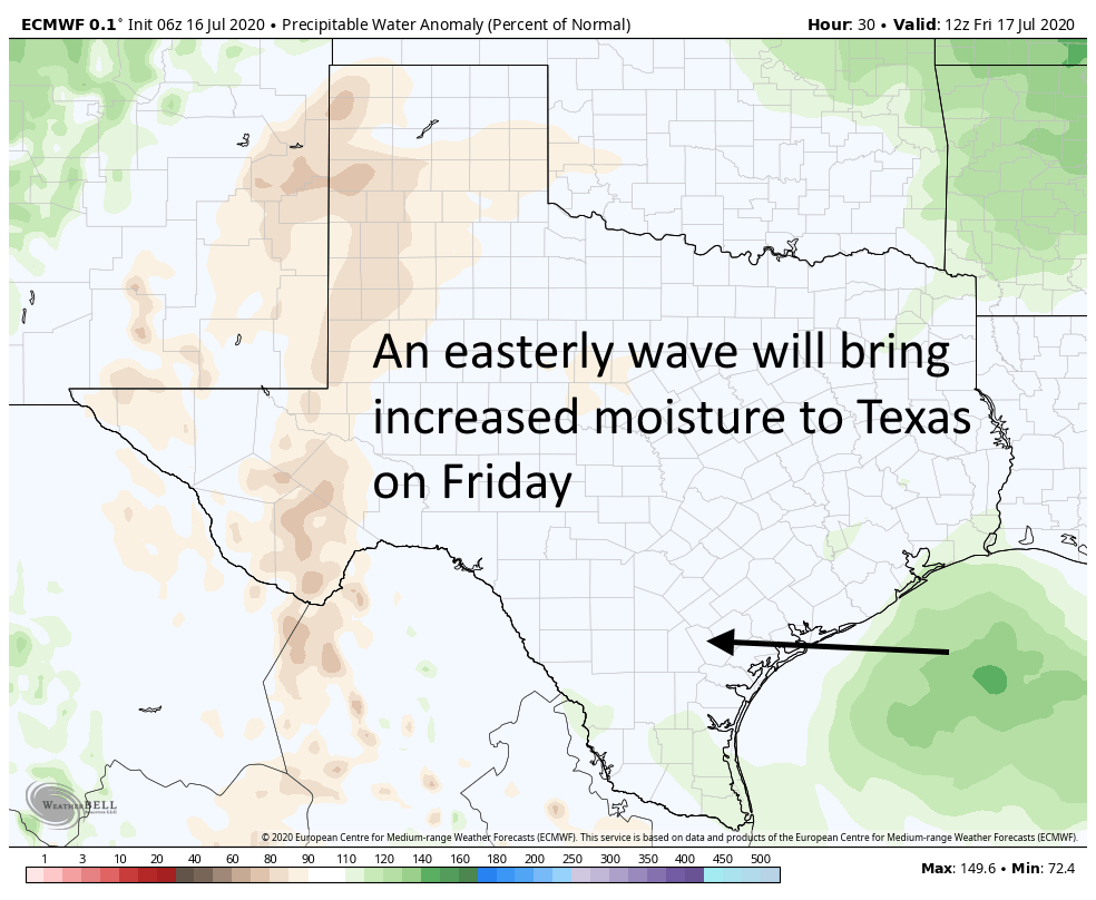
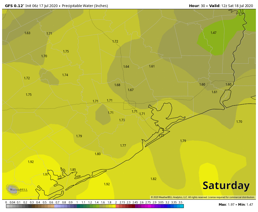
It would seem another weak disturbance may pass through on Monday, coinciding with an increase in Gulf moisture, which could bump our rain chances up a notch or two relative to the weekend. We’ve thrown precipitable water (how much moisture is available in the atmosphere) on the map below, and you can see that by late Sunday and especially Monday, we see an influx of Gulf moisture, with PWATs over 2 inches again.

Precipitable water (PWAT, or how much moisture is available in the atmosphere) will increase Monday, leading to better rain chances. (Weather Bell)

It still doesn’t appear that everyone will see a dousing here, but coverage of rain will be noticeably greater on Monday than it will be Saturday or Sunday. Tuesday should similarly see scattered showers or storms as well. Daytime highs will come off a couple degrees, so mainly lower 90s, maybe a few upper-80s in spots, with lows generally in the 70s, except perhaps at the coast.

Rest of next week

We will probably see a continued pattern of typical summer: Hot, humid, sunny for the most part, and days with one or two showers punctuated by a day or two of higher rain chances as some easterly waves move in off the Gulf. Friday may be one of the more active days as it stands right now. Settle in for a more standard Houston summer.

Last really hot day before—gasp—rain chances return Friday

It’s another sticky morning across the Houston region, with lows at 80 degrees or above for most of the region. Normal lows this time of year run about five degrees cooler so the real heat this month has come during the nights. We expect the overnight lows to moderate slightly over the next few days, but we’ll remain at least in the upper 70s. The bigger change will be apparent in daytime highs, as we fall back toward the low-to-mid 90s after today.

Thursday

If you liked Wednesday’s weather then you’re in luck, because today will bring more of the same. Although high pressure should begin to weaken, it’s still going to retain enough of a grip to send high temperatures soaring into the upper 90s across the area. Morning clouds should give way to afternoon sunshine.

One effect of an easterly wave on Friday will be increased moisture levels. (Weather Bell)

Friday

Our weather pattern should really change on Friday. Highs pressure will back off just enough to allow a weak low pressure system to move from east to west across the area. This should bring scattered, light to moderate showers along the coast during the morning, and spread inland during the afternoon and evening hours. Will you get rain? If you live south of Interstate 10, chances are probably in the 50 percent range, and lower if you live north. Accumulations for some may be up to one-half inch, but most people will see less than this. Highs should otherwise be in the mid-90s.

Saturday and Sunday

The weekend should see fairly standard weather for Houston in July, which is to say highs in the low- to mid-90s, with partly to mostly sunny skies. We may see some isolated to scattered showers driven by the sea breeze, but overall rain chances will be quite low.

Next week

Most of next week should see highs in the low 90s, with a mix of sunshine and clouds. On average, each day should have around a 30 percent chance of rain, but of course some days will have better and worse chances. We’ll refine that forecast as we get closer to it.

After record-setting warm nights, some relief looms at last

So it’s been hot in Houston this month, especially the nights. The low temperature this morning at Houston Hobby Airport is likely to fall no lower than 81 degrees. This would make for the tenth day so far in July that the temperature has failed to fall below 80 degrees at that location. This extends a new record for mornings with 80- degree mornings, or above, for the month of July. The previous record for the most of these days at Hobby was eight, in 2016, according the National Weather Service. Also, July is not quite half over yet.

Low temperatures in the Houston region have been 4 to 6 degrees warmer than normal in July. (Unl.edu)

Fortunately, some scant relief is coming as the high pressure that has dominated our weather this month begins to weaken and slide east. This will slowly bring down temperatures and, eventually, introduce some moderate rain chances to the area. We think the second half of this month will be much closer to “normal” for a Houston summer than the extremely warm nights and days we’ve experienced over the last two weeks.

Wednesday

Today, however, will not provide too much of a change. Highs probably will still reach into the mid- to upper-90s for the region, with partly to mostly sunny skies this afternoon. Winds from the south at 5 to 10 mph will provide a bit of relief, and then we will be in for another very warm night, with lows possibly falling into the upper 70s for inland areas.

See full post

Eye on the Tropics: Lull in activity expected for a bit longer

Welcome to Eye on the Tropics, Powered by Reliant.

With the formation of Fay last week, we’re off to the fastest start on record in the Atlantic basin if you used named storms as your benchmark. Thankfully, we are setup right now for a bit of a quiet period, possibly through the end of July.

Tropical outlook in a sentence

We do not expect any tropical activity of note for the 7 days and probably longer.

Fast start should slow again

Two weeks ago, we had Edouard to discuss. Last week, we hinted at the risk that Fay could form. That happened, and now things are once again quiet in the tropics. We don’t see any sneaky system risk for the next 5 to 7 days, and nothing of note seems to be showing up beyond that. So we can exhale for the time being, and let us revisit 2020’s frenetic pace.

Fay was the fastest we’ve gotten to the “F” storm, or 6th named storm on record in the tropics, with the usual caveat that we easily could have missed a storm or two in previous years before weather satellites. Still, that is what the record books will say. Typically, we don’t get to the letter F until about September 8th. Of course, as we know, all of this year’s tropical storms have been fairly pedestrian in nature. The accumulated cyclone energy (or the sum of wind speed every 6 hours for every storm) is a mere 7.8, or what is typical for August 2nd.

The accumulated cyclone energy of this year’s hurricane season is running about 2 to 3 weeks ahead of normal. (Colorado State)

The earliest “G” storm is 2005’s Gert on July 24th. It seems unlikely that this domino will fall right now. So far at least, this year is about quantity, not quality. That isn’t a bad thing.

What is next?

The obvious question everyone will have is: If things are going to quiet down, when will we see the next wave of activity? The answer is that we don’t know. Now, I will say that the risk of activity over the next 5 to 7 days seems close to zero. However, once we go beyond that period, there is always a chance something rogue could develop local to the Gulf that is absent from all models at present. We don’t see any evidence of that being a risk right now, but folks should understand the time horizon we can reasonably forecast for is limited when it comes to these things. But at a large scale, things look to remain quiet for probably the next two weeks.

While there are some more robust tropical waves beginning to emerge off Africa, none right now looks to be a serious candidate for development. (Weathernerds.org)

Dust is still pretty widespread, and even though we should begin to see beefier waves emerge off Africa, the odds of any one developing is fairly low. Looking at some meteorological data, it would seem to me that early to mid-August may provide our next chance to begin to get some development going on any meaningful scale. By then, dust and dry air should begin to become a little less dense, and we may see some background level support for more activity. One issue plaguing the Atlantic right now, despite a lot of other background signals being supportive of a very busy season is that vertical instability is rather low.

Vertical instability is lacking in the Atlantic basin right now, which may help hurricane season stay relatively lackluster for a bit longer. (NOAA)

We can use this as sort of a rough gauge as to what kind of state the Atlantic is in, and right now it happens to be in a pretty suppressed one, which does not support storm formation. Instability breeds thunderstorms, which can breed tropical storms. This doesn’t need to be rocking for the season to be active, but if you were seeking development of a meaningful nature, you would want to see this change. That being said, we’ve had six storms with really depressed basin-wide instability. If this does turn a corner, it’s likely that we’re going to be off to the races.

Hurricane season is a marathon, and there are numerous signals and hints you can focus in on or get distracted by. While this is a rather significant signal right now, and it’s likely helping us to keep quiet for the time being, it does not mean it will last forever. We will maintain vigilance. More for you next week!